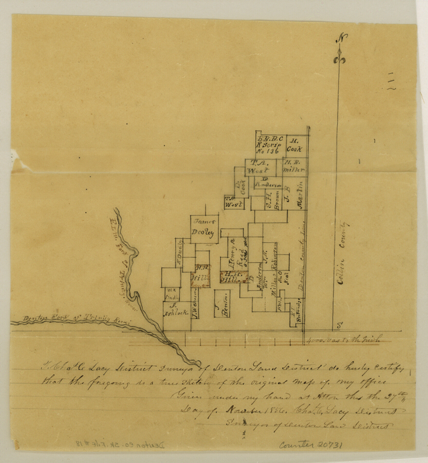
Denton County Sketch File 18
[Sketch of surveys in southeast corner of the county just east of the Trinity River]
-
Map/Doc
20731
-
Collection
General Map Collection
-
Object Dates
1856/11/26 (Creation Date)
1857/5/28 (File Date)
-
People and Organizations
Chas. C. Lacy (Surveyor/Engineer)
-
Counties
Denton
-
Subjects
Surveying Sketch File
-
Height x Width
7.9 x 7.3 inches
20.1 x 18.5 cm
-
Medium
paper, manuscript
-
Scale
1:4000
-
Features
Elm Fork of Trinity River
Denton Fork of Trinity River
Part of: General Map Collection

West Houston: Hwy. 6 from Spencer Rd. in the North to South of Sugar Land. From Wilcrest Dr. in the East to and including Katy.

West Houston: Hwy. 6 from Spencer Rd. in the North to South of Sugar Land. From Wilcrest Dr. in the East to and including Katy.
Size 35.4 x 22.7 inches
Map/Doc 94336
[Galveston, Harrisburg & San Antonio Railroad from Cuero to Stockdale]
![64199, [Galveston, Harrisburg & San Antonio Railroad from Cuero to Stockdale], General Map Collection](https://historictexasmaps.com/wmedia_w700/maps/64199.tif.jpg)
Print $20.00
- Digital $50.00
[Galveston, Harrisburg & San Antonio Railroad from Cuero to Stockdale]
1907
Size 12.9 x 33.2 inches
Map/Doc 64199
Angelina County Sketch File 1

Print $40.00
- Digital $50.00
Angelina County Sketch File 1
1848
Size 14.9 x 12.7 inches
Map/Doc 12919
Flight Mission No. DAG-17K, Frame 124, Matagorda County

Print $20.00
- Digital $50.00
Flight Mission No. DAG-17K, Frame 124, Matagorda County
1952
Size 18.6 x 22.3 inches
Map/Doc 86344
Real County Rolled Sketch 18

Print $20.00
- Digital $50.00
Real County Rolled Sketch 18
Size 18.5 x 24.3 inches
Map/Doc 7462
Sherman County Boundary File Index

Print $2.00
- Digital $50.00
Sherman County Boundary File Index
Size 8.8 x 13.2 inches
Map/Doc 58750
Jackson County Sketch File 30

Print $52.00
- Digital $50.00
Jackson County Sketch File 30
1944
Size 14.2 x 8.5 inches
Map/Doc 27730
Kenedy County Working Sketch Graphic Index

Print $20.00
- Digital $50.00
Kenedy County Working Sketch Graphic Index
1978
Size 46.6 x 35.8 inches
Map/Doc 76603
Map of Williamson County

Print $20.00
- Digital $50.00
Map of Williamson County
1876
Size 21.2 x 28.6 inches
Map/Doc 4152
Waller County Sketch File 5

Print $6.00
- Digital $50.00
Waller County Sketch File 5
Size 10.7 x 14.1 inches
Map/Doc 39600
Burnet County Working Sketch 14

Print $20.00
- Digital $50.00
Burnet County Working Sketch 14
1978
Size 37.0 x 38.5 inches
Map/Doc 67857
You may also like
Shackelford County Working Sketch 9

Print $20.00
- Digital $50.00
Shackelford County Working Sketch 9
1974
Size 30.1 x 22.2 inches
Map/Doc 63849
Hamilton County

Print $20.00
- Digital $50.00
Hamilton County
1916
Size 42.3 x 43.2 inches
Map/Doc 66850
Wichita County Sketch File 36

Print $20.00
- Digital $50.00
Wichita County Sketch File 36
1894
Size 20.1 x 25.9 inches
Map/Doc 12689
Brown County Working Sketch 6

Print $20.00
- Digital $50.00
Brown County Working Sketch 6
1948
Size 12.9 x 19.3 inches
Map/Doc 67771
Eastland County Working Sketch 63

Print $20.00
- Digital $50.00
Eastland County Working Sketch 63
1997
Size 36.7 x 37.6 inches
Map/Doc 68844
San Patricio County Working Sketch Graphic Index

Print $20.00
- Digital $50.00
San Patricio County Working Sketch Graphic Index
1939
Size 36.6 x 47.9 inches
Map/Doc 76692
Montgomery County Working Sketch 51

Print $20.00
- Digital $50.00
Montgomery County Working Sketch 51
1960
Size 38.7 x 40.4 inches
Map/Doc 71158
Kendall County Rolled Sketch 9

Print $20.00
- Digital $50.00
Kendall County Rolled Sketch 9
1990
Size 32.8 x 24.3 inches
Map/Doc 95298
Map of north end of Brazos Island

Print $20.00
- Digital $50.00
Map of north end of Brazos Island
Size 27.5 x 18.4 inches
Map/Doc 72905
Jefferson County Sketch File 46

Print $20.00
- Digital $50.00
Jefferson County Sketch File 46
1933
Size 20.8 x 31.2 inches
Map/Doc 11880
Flight Mission No. DIX-5P, Frame 116, Aransas County

Print $20.00
- Digital $50.00
Flight Mission No. DIX-5P, Frame 116, Aransas County
1956
Size 17.8 x 18.1 inches
Map/Doc 83795
Leon County Working Sketch 49

Print $20.00
- Digital $50.00
Leon County Working Sketch 49
1981
Size 23.9 x 24.7 inches
Map/Doc 70448