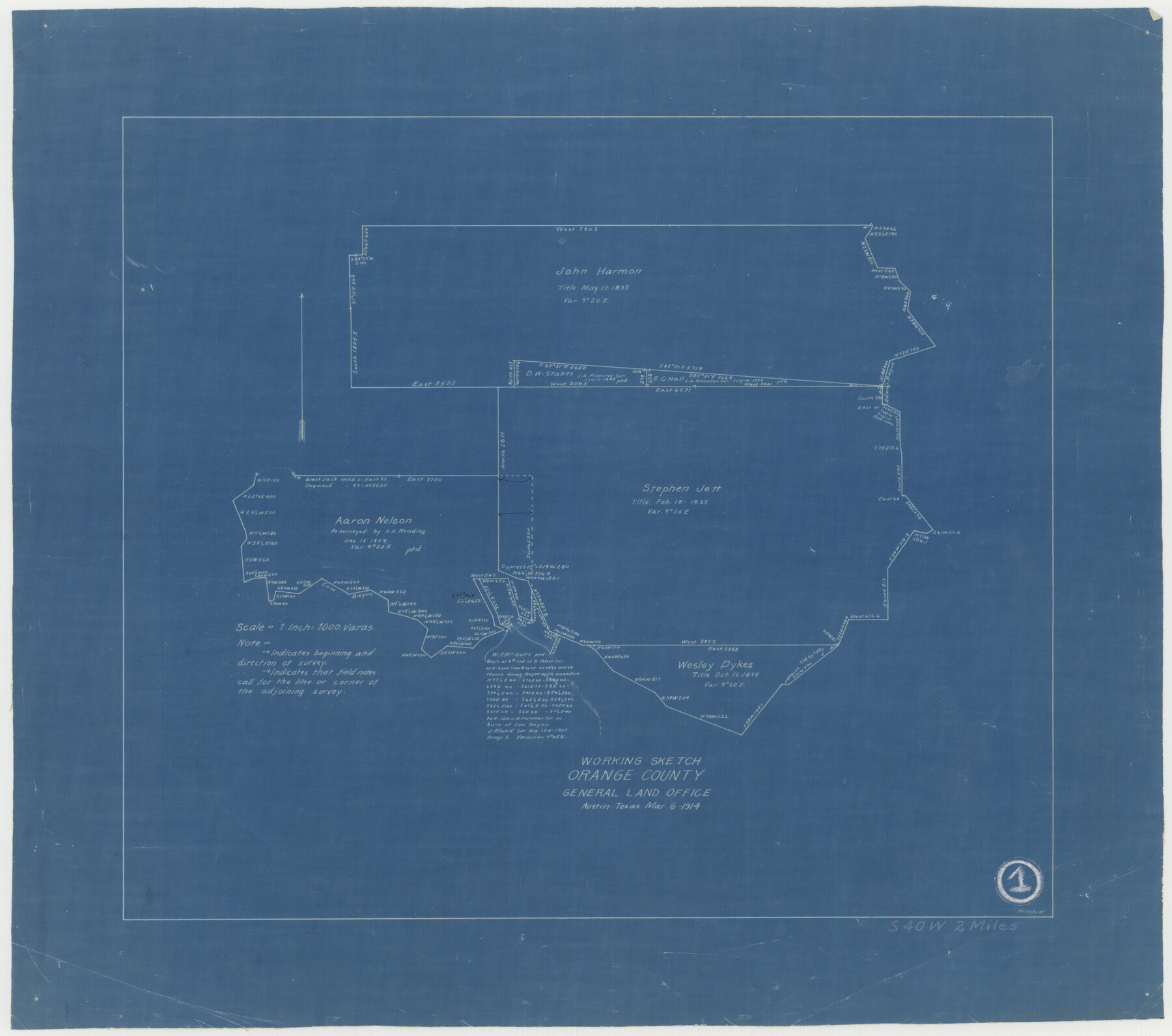
Orange County Working Sketch 1
-
Map/Doc
71333
-
Collection
General Map Collection
-
Object Dates
3/6/1914 (Creation Date)
-
People and Organizations
J.W. Pritchett (Draftsman)
-
Counties
Orange
-
Subjects
Surveying Working Sketch
-
Height x Width
16.1 x 18.2 inches
40.9 x 46.2 cm
-
Scale
1" = 1000 varas
Part of: General Map Collection
Flight Mission No. DQO-1K, Frame 91, Galveston County

Print $20.00
- Digital $50.00
Flight Mission No. DQO-1K, Frame 91, Galveston County
1952
Size 18.8 x 22.4 inches
Map/Doc 84987
Flight Mission No. CUG-3P, Frame 78, Kleberg County

Print $20.00
- Digital $50.00
Flight Mission No. CUG-3P, Frame 78, Kleberg County
1956
Size 18.5 x 22.2 inches
Map/Doc 86253
Flight Mission No. CUG-3P, Frame 132, Kleberg County

Print $20.00
- Digital $50.00
Flight Mission No. CUG-3P, Frame 132, Kleberg County
1956
Size 18.4 x 22.4 inches
Map/Doc 86267
Hutchinson County Sketch File 15

Print $20.00
- Digital $50.00
Hutchinson County Sketch File 15
Size 20.7 x 26.7 inches
Map/Doc 11813
Map of Hopkins County

Print $20.00
- Digital $50.00
Map of Hopkins County
1872
Size 17.5 x 17.9 inches
Map/Doc 4567
Jasper County

Print $40.00
- Digital $50.00
Jasper County
1898
Size 64.2 x 35.6 inches
Map/Doc 78413
Lee County Rolled Sketch 1

Print $40.00
- Digital $50.00
Lee County Rolled Sketch 1
1939
Size 71.1 x 45.2 inches
Map/Doc 9562
Hardin County Sketch File 9

Print $4.00
- Digital $50.00
Hardin County Sketch File 9
1865
Size 12.4 x 8.2 inches
Map/Doc 25106
Flight Mission No. DCL-7C, Frame 17, Kenedy County

Print $20.00
- Digital $50.00
Flight Mission No. DCL-7C, Frame 17, Kenedy County
1943
Size 15.3 x 15.2 inches
Map/Doc 86009
Culberson County Rolled Sketch 54

Print $40.00
- Digital $50.00
Culberson County Rolled Sketch 54
1968
Size 59.0 x 29.4 inches
Map/Doc 10300
Liberty County Sketch File 68

Print $24.00
- Digital $50.00
Liberty County Sketch File 68
Size 11.0 x 8.5 inches
Map/Doc 94021
Harrison County

Print $20.00
- Digital $50.00
Harrison County
1920
Size 45.1 x 41.8 inches
Map/Doc 1850
You may also like
Jim Hogg County Working Sketch 2

Print $20.00
- Digital $50.00
Jim Hogg County Working Sketch 2
1933
Size 41.2 x 29.3 inches
Map/Doc 66588
Amistad International Reservoir on Rio Grande 97

Print $20.00
- Digital $50.00
Amistad International Reservoir on Rio Grande 97
1950
Size 28.5 x 41.1 inches
Map/Doc 75528
[Ft. W. & R. G. Ry. Right of Way Map, Chapin to Bluffdale, Hood County, Texas]
![64644, [Ft. W. & R. G. Ry. Right of Way Map, Chapin to Bluffdale, Hood County, Texas], General Map Collection](https://historictexasmaps.com/wmedia_w700/maps/64644.tif.jpg)
Print $40.00
- Digital $50.00
[Ft. W. & R. G. Ry. Right of Way Map, Chapin to Bluffdale, Hood County, Texas]
1918
Size 37.7 x 84.3 inches
Map/Doc 64644
Webb County Working Sketch 68

Print $40.00
- Digital $50.00
Webb County Working Sketch 68
1967
Size 31.6 x 50.7 inches
Map/Doc 72435
Orange County Working Sketch 22

Print $20.00
- Digital $50.00
Orange County Working Sketch 22
1939
Size 35.8 x 35.5 inches
Map/Doc 71354
Current Miscellaneous File 95

Print $24.00
- Digital $50.00
Current Miscellaneous File 95
1994
Size 8.8 x 11.3 inches
Map/Doc 74270
Brewster County Sketch File 57

Print $6.00
- Digital $50.00
Brewster County Sketch File 57
2008
Size 11.0 x 8.5 inches
Map/Doc 88871
Hays County Working Sketch 3

Print $20.00
- Digital $50.00
Hays County Working Sketch 3
1925
Size 28.2 x 24.1 inches
Map/Doc 66077
Chambers County Rolled Sketch 23

Print $40.00
- Digital $50.00
Chambers County Rolled Sketch 23
1940
Size 36.5 x 49.2 inches
Map/Doc 8591
Kimble County Rolled Sketch 15

Print $59.00
- Digital $50.00
Kimble County Rolled Sketch 15
1886
Size 28.3 x 42.1 inches
Map/Doc 6508
Presidio County Rolled Sketch 93

Print $20.00
- Digital $50.00
Presidio County Rolled Sketch 93
Size 35.5 x 31.1 inches
Map/Doc 7378
Map showing the route of the Louisville, New Orleans, and Texas Railroad and its connecting lines.

Print $20.00
Map showing the route of the Louisville, New Orleans, and Texas Railroad and its connecting lines.
1883
Size 18.1 x 44.1 inches
Map/Doc 93605