Hemphill County Boundary File 3
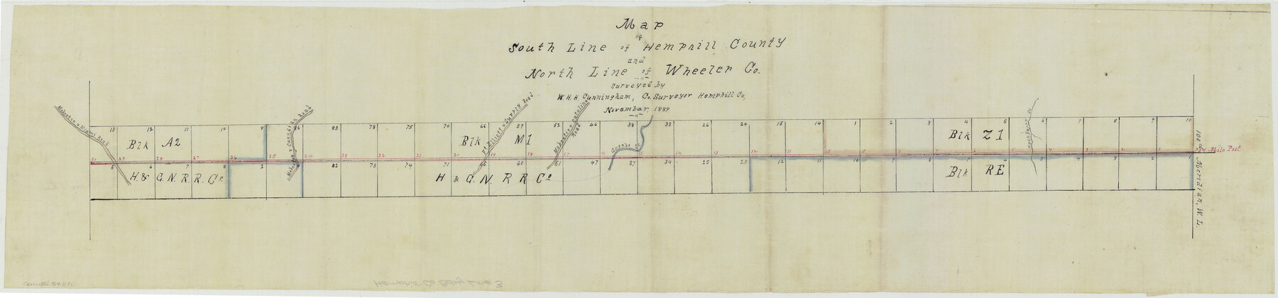
Map of South Line of Hemphill County and North Line of Wheeler Co.
-
Map/Doc
54630
-
Collection
General Map Collection
-
Counties
Hemphill
-
Subjects
County Boundaries
-
Height x Width
7.7 x 32.9 inches
19.6 x 83.6 cm
Part of: General Map Collection
Nueces County Rolled Sketch 89

Print $235.00
Nueces County Rolled Sketch 89
1983
Size 18.0 x 24.2 inches
Map/Doc 6991
Flight Mission No. DQO-2K, Frame 136, Galveston County

Print $20.00
- Digital $50.00
Flight Mission No. DQO-2K, Frame 136, Galveston County
1952
Size 18.8 x 22.6 inches
Map/Doc 85033
Nueces County Rolled Sketch 123 A-D

Print $10.00
- Digital $50.00
Nueces County Rolled Sketch 123 A-D
1997
Size 11.3 x 8.8 inches
Map/Doc 41586
Hunt County Sketch File 34a

Print $4.00
- Digital $50.00
Hunt County Sketch File 34a
1873
Size 8.0 x 10.1 inches
Map/Doc 27146
Parmer County Working Sketch 1

Print $20.00
- Digital $50.00
Parmer County Working Sketch 1
1903
Map/Doc 71469
Flight Mission No. BRE-2P, Frame 122, Nueces County

Print $20.00
- Digital $50.00
Flight Mission No. BRE-2P, Frame 122, Nueces County
1956
Size 18.4 x 22.4 inches
Map/Doc 86798
Williamson County Sketch File 19

Print $24.00
- Digital $50.00
Williamson County Sketch File 19
Size 12.8 x 8.0 inches
Map/Doc 40345
Aransas County Rolled Sketch 29

Print $20.00
- Digital $50.00
Aransas County Rolled Sketch 29
1961
Size 35.8 x 31.1 inches
Map/Doc 77497
Supreme Court of the United States, October Term, 1924, No. 13, Original - The State of Oklahoma, Complainant vs. The State of Texas, Defendant, The United States, Intervener

Print $20.00
- Digital $50.00
Supreme Court of the United States, October Term, 1924, No. 13, Original - The State of Oklahoma, Complainant vs. The State of Texas, Defendant, The United States, Intervener
1924
Size 16.5 x 33.1 inches
Map/Doc 75113
A Map of the Cotton Kingdom and its Dependencies in America

Print $20.00
- Digital $50.00
A Map of the Cotton Kingdom and its Dependencies in America
1861
Size 12.2 x 18.6 inches
Map/Doc 96573
Bastrop County

Print $20.00
- Digital $50.00
Bastrop County
1917
Size 45.5 x 40.8 inches
Map/Doc 66711
McMullen County Sketch File 46

Print $6.00
- Digital $50.00
McMullen County Sketch File 46
1943
Size 14.3 x 8.7 inches
Map/Doc 31434
You may also like
Tarrant County Boundary File 3

Print $30.00
- Digital $50.00
Tarrant County Boundary File 3
Size 11.4 x 8.8 inches
Map/Doc 59136
General Highway Map, Cooke County, Texas

Print $20.00
General Highway Map, Cooke County, Texas
1961
Size 24.8 x 18.2 inches
Map/Doc 79421
Llano County Sketch File 10

Print $10.00
- Digital $50.00
Llano County Sketch File 10
1886
Size 8.2 x 7.6 inches
Map/Doc 30370
[Pencil sketch showing various surveys south and along Holiday Creek]
![89978, [Pencil sketch showing various surveys south and along Holiday Creek], Twichell Survey Records](https://historictexasmaps.com/wmedia_w700/maps/89978-1.tif.jpg)
Print $20.00
- Digital $50.00
[Pencil sketch showing various surveys south and along Holiday Creek]
Size 28.3 x 18.8 inches
Map/Doc 89978
McLennan County Working Sketch 7

Print $20.00
- Digital $50.00
McLennan County Working Sketch 7
1959
Size 22.6 x 23.9 inches
Map/Doc 70700
Stonewall County Sketch File 8

Print $14.00
- Digital $50.00
Stonewall County Sketch File 8
1896
Size 8.7 x 7.7 inches
Map/Doc 37222
Flight Mission No. BRE-1P, Frame 51, Nueces County

Print $20.00
- Digital $50.00
Flight Mission No. BRE-1P, Frame 51, Nueces County
1956
Size 18.3 x 22.2 inches
Map/Doc 86640
Dimmit County Boundary File 10

Print $32.00
- Digital $50.00
Dimmit County Boundary File 10
Size 14.2 x 8.6 inches
Map/Doc 52604
Leon County Boundary File 1

Print $34.00
- Digital $50.00
Leon County Boundary File 1
Size 21.0 x 6.6 inches
Map/Doc 56281
Wise County Sketch File 34

Print $6.00
- Digital $50.00
Wise County Sketch File 34
1856
Size 6.3 x 9.6 inches
Map/Doc 40592
Kaufman County Sketch File 3

Print $20.00
- Digital $50.00
Kaufman County Sketch File 3
1857
Size 25.3 x 18.7 inches
Map/Doc 4856
Harris County NRC Article 33.136 Sketch 11

Print $28.00
- Digital $50.00
Harris County NRC Article 33.136 Sketch 11
2007
Size 24.0 x 36.0 inches
Map/Doc 94658