Castro County Sketch File A
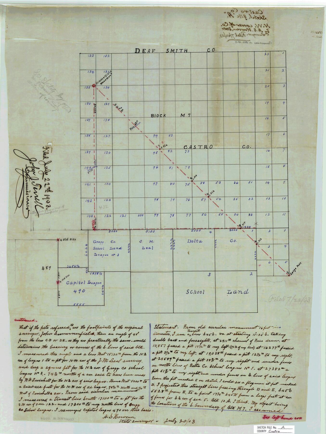
[Sketch of surveys in Block M7, north of County School Land leagues in northeast part of Castro County and south part of Deaf Smith County]
-
Map/Doc
11064
-
Collection
General Map Collection
-
Object Dates
1903/7/20 (Creation Date)
1903/7/22 (File Date)
-
People and Organizations
A.S. Howren (Surveyor/Engineer)
-
Counties
Deaf Smith Castro
-
Subjects
Surveying Sketch File
-
Height x Width
25.8 x 19.4 inches
65.5 x 49.3 cm
-
Medium
paper, manuscript
-
Features
Frio River
Part of: General Map Collection
Pecos County Rolled Sketch 90A

Print $20.00
- Digital $50.00
Pecos County Rolled Sketch 90A
1934
Size 27.0 x 31.1 inches
Map/Doc 7246
Red River County Working Sketch 67

Print $20.00
- Digital $50.00
Red River County Working Sketch 67
1974
Size 46.9 x 37.7 inches
Map/Doc 72050
Bosque County Sketch File 5

Print $6.00
- Digital $50.00
Bosque County Sketch File 5
1847
Size 15.7 x 10.4 inches
Map/Doc 14746
Harrison County Working Sketch 25

Print $20.00
- Digital $50.00
Harrison County Working Sketch 25
1983
Size 21.9 x 24.0 inches
Map/Doc 66045
Morris County Rolled Sketch 2A

Print $20.00
- Digital $50.00
Morris County Rolled Sketch 2A
Size 24.4 x 19.3 inches
Map/Doc 10266
Borden County Working Sketch 16

Print $40.00
- Digital $50.00
Borden County Working Sketch 16
2007
Size 48.0 x 29.4 inches
Map/Doc 87206
Shelby County Sketch File 30

Print $4.00
- Digital $50.00
Shelby County Sketch File 30
1927
Size 14.3 x 8.8 inches
Map/Doc 36668
Coleman County Sketch File 25

Print $40.00
- Digital $50.00
Coleman County Sketch File 25
1872
Size 12.5 x 15.8 inches
Map/Doc 18710
Young County Sketch File 12

Print $4.00
- Digital $50.00
Young County Sketch File 12
1889
Size 8.5 x 13.6 inches
Map/Doc 40876
Current Miscellaneous File 105

Print $18.00
- Digital $50.00
Current Miscellaneous File 105
Size 8.8 x 14.2 inches
Map/Doc 74680
Hansford County Working Sketch 3

Print $20.00
- Digital $50.00
Hansford County Working Sketch 3
1940
Size 20.5 x 16.5 inches
Map/Doc 63375
Gray County Sketch File 8

Print $20.00
- Digital $50.00
Gray County Sketch File 8
1888
Size 17.7 x 20.7 inches
Map/Doc 11577
You may also like
The Chief Justice County of Gonzales. July 7, 1837

Print $20.00
The Chief Justice County of Gonzales. July 7, 1837
2020
Size 22.3 x 21.7 inches
Map/Doc 96047
Revised Map of Block "A", Parmer County

Print $20.00
- Digital $50.00
Revised Map of Block "A", Parmer County
1913
Size 21.1 x 23.9 inches
Map/Doc 91609
Lubbock County Working Sketch 5

Print $20.00
- Digital $50.00
Lubbock County Working Sketch 5
1950
Size 14.3 x 31.0 inches
Map/Doc 70665
Garza County Sketch File 25a

Print $14.00
- Digital $50.00
Garza County Sketch File 25a
Size 11.4 x 8.8 inches
Map/Doc 24088
Edwards County Working Sketch 113

Print $20.00
- Digital $50.00
Edwards County Working Sketch 113
1972
Size 39.1 x 36.0 inches
Map/Doc 68989
Morris County Rolled Sketch 2A

Print $20.00
- Digital $50.00
Morris County Rolled Sketch 2A
Size 24.0 x 18.7 inches
Map/Doc 10256
Duval County Rolled Sketch DCR

Print $40.00
- Digital $50.00
Duval County Rolled Sketch DCR
1931
Size 41.8 x 93.5 inches
Map/Doc 8804
Flight Mission No. DAG-19K, Frame 59, Matagorda County

Print $20.00
- Digital $50.00
Flight Mission No. DAG-19K, Frame 59, Matagorda County
1952
Size 18.6 x 22.2 inches
Map/Doc 86386
Deaf Smith Co.

Print $40.00
- Digital $50.00
Deaf Smith Co.
1898
Size 37.2 x 48.8 inches
Map/Doc 4930
General Highway Map, La Salle County, Texas

Print $20.00
General Highway Map, La Salle County, Texas
1961
Size 18.2 x 24.8 inches
Map/Doc 79565
La table des isles neufues, lesquelles on appelle isles d'occident & d'Indie pour divers regardz

Print $20.00
- Digital $50.00
La table des isles neufues, lesquelles on appelle isles d'occident & d'Indie pour divers regardz
1552
Size 12.3 x 15.7 inches
Map/Doc 95836
Map of Kerr County, Texas

Print $20.00
- Digital $50.00
Map of Kerr County, Texas
1879
Size 21.7 x 28.5 inches
Map/Doc 526