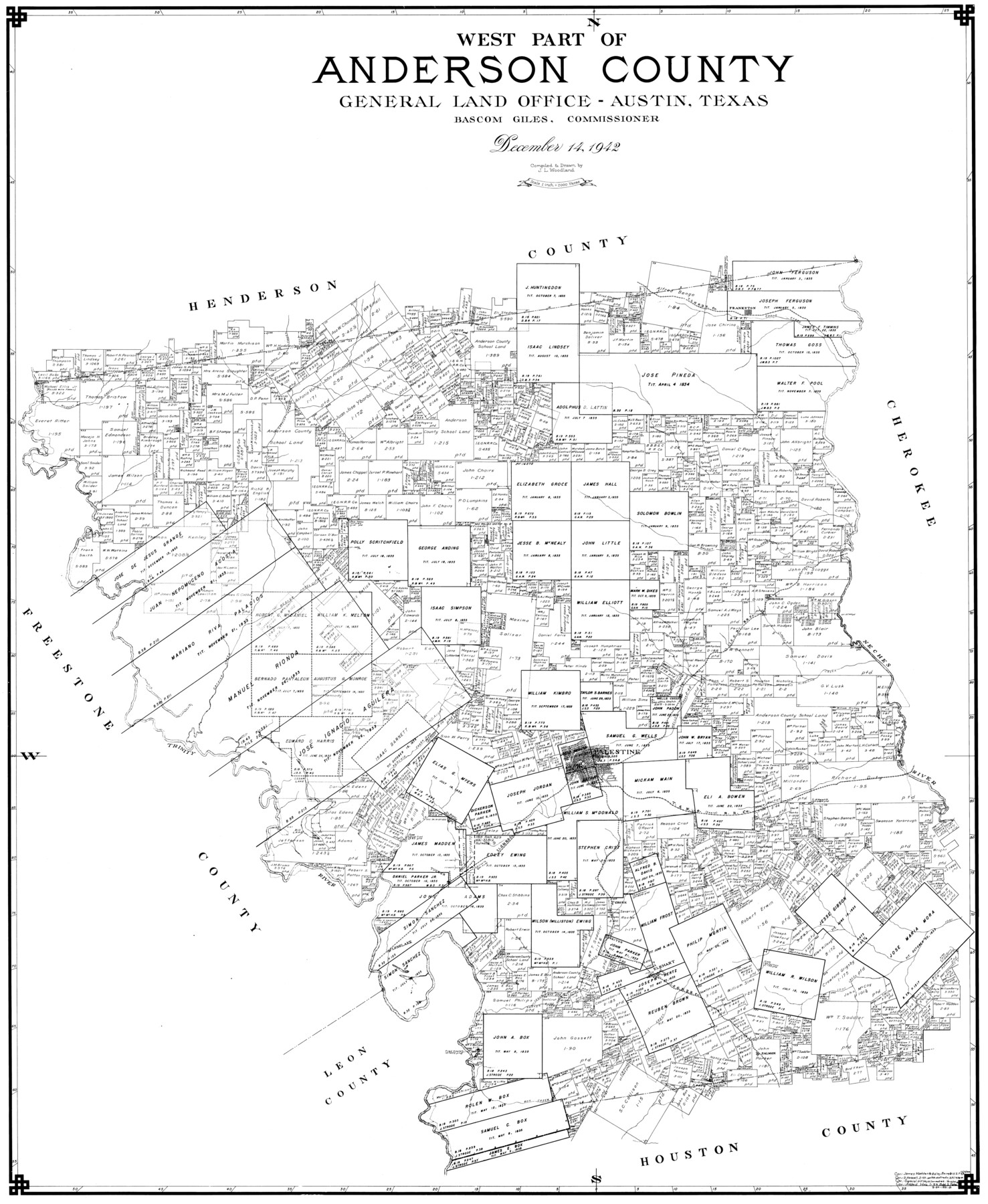
West Part of Anderson County
-
Map/Doc
77197
-
Collection
General Map Collection
-
Object Dates
1942/12/14 (Creation Date)
-
Counties
Anderson
-
Subjects
County
-
Height x Width
41.8 x 34.3 inches
106.2 x 87.1 cm
Part of: General Map Collection
Robertson County Sketch File 12

Print $18.00
Robertson County Sketch File 12
1987
Size 11.4 x 8.8 inches
Map/Doc 35404
Flight Mission No. BRA-16M, Frame 96, Jefferson County

Print $20.00
- Digital $50.00
Flight Mission No. BRA-16M, Frame 96, Jefferson County
1953
Size 18.6 x 22.4 inches
Map/Doc 85708
Midland County Sketch File 17

Print $26.00
- Digital $50.00
Midland County Sketch File 17
1955
Size 11.2 x 8.7 inches
Map/Doc 31582

Goliad County Sketch File 19

Print $10.00
- Digital $50.00
Goliad County Sketch File 19
Size 12.9 x 8.0 inches
Map/Doc 24260
Jefferson County Sketch File 22

Print $22.00
- Digital $50.00
Jefferson County Sketch File 22
Size 7.6 x 11.9 inches
Map/Doc 28179
Flight Mission No. DQN-1K, Frame 65, Calhoun County

Print $20.00
- Digital $50.00
Flight Mission No. DQN-1K, Frame 65, Calhoun County
1953
Size 18.5 x 22.2 inches
Map/Doc 84152
Culberson County Sketch File 14

Print $28.00
- Digital $50.00
Culberson County Sketch File 14
1928
Size 13.3 x 8.0 inches
Map/Doc 20176
Garza County Sketch File D

Print $20.00
- Digital $50.00
Garza County Sketch File D
1901
Size 18.4 x 12.2 inches
Map/Doc 11550
Flight Mission No. DQO-8K, Frame 76, Galveston County

Print $20.00
- Digital $50.00
Flight Mission No. DQO-8K, Frame 76, Galveston County
1952
Size 18.6 x 22.5 inches
Map/Doc 85180
Bell County Working Sketch 13

Print $20.00
- Digital $50.00
Bell County Working Sketch 13
1964
Size 19.6 x 18.5 inches
Map/Doc 67353
Childress County Sketch File 15a

Print $4.00
- Digital $50.00
Childress County Sketch File 15a
Size 8.6 x 11.7 inches
Map/Doc 18303
You may also like
[Sketch for Mineral Applications 26885-6 - Reagan and Crockett Cos., W. H. Bland]
![65672, [Sketch for Mineral Applications 26885-6 - Reagan and Crockett Cos., W. H. Bland], General Map Collection](https://historictexasmaps.com/wmedia_w700/maps/65672-1.tif.jpg)
Print $40.00
- Digital $50.00
[Sketch for Mineral Applications 26885-6 - Reagan and Crockett Cos., W. H. Bland]
Size 51.1 x 37.3 inches
Map/Doc 65672
Callahan County Boundary File 1a

Print $4.00
- Digital $50.00
Callahan County Boundary File 1a
Size 13.3 x 8.7 inches
Map/Doc 51085
Refugio County Boundary File 1

Print $6.00
- Digital $50.00
Refugio County Boundary File 1
Size 8.1 x 3.4 inches
Map/Doc 58225
Newton County Working Sketch 25

Print $20.00
- Digital $50.00
Newton County Working Sketch 25
1953
Size 25.4 x 23.8 inches
Map/Doc 71271
Schleicher County Rolled Sketch 15

Print $20.00
- Digital $50.00
Schleicher County Rolled Sketch 15
Size 28.8 x 41.0 inches
Map/Doc 7757
Shelby County Working Sketch 23b

Print $20.00
- Digital $50.00
Shelby County Working Sketch 23b
1983
Size 36.6 x 24.7 inches
Map/Doc 63877
From Citizens of Shelby County Living on the South Side of Patroon Bayou to Have the Area Annexed to San Augustine County, November 1, 1841

Print $20.00
From Citizens of Shelby County Living on the South Side of Patroon Bayou to Have the Area Annexed to San Augustine County, November 1, 1841
2020
Size 12.1 x 21.7 inches
Map/Doc 96393
Matagorda County NRC Article 33.136 Sketch 16

Digital $50.00
Matagorda County NRC Article 33.136 Sketch 16
2023
Map/Doc 97256
Map of Falls County

Print $20.00
- Digital $50.00
Map of Falls County
1855
Size 21.4 x 23.9 inches
Map/Doc 3532
Dimmit County Sketch File 62

Print $8.00
- Digital $50.00
Dimmit County Sketch File 62
2012
Size 11.0 x 8.5 inches
Map/Doc 93631
Jefferson County NRC Article 33.136 Sketch 10

Print $28.00
- Digital $50.00
Jefferson County NRC Article 33.136 Sketch 10
2012
Size 24.0 x 36.0 inches
Map/Doc 94575
Harris County Historic Topographic 5

Print $20.00
- Digital $50.00
Harris County Historic Topographic 5
1916
Size 29.2 x 22.8 inches
Map/Doc 65815