Concho County Sketch File 25
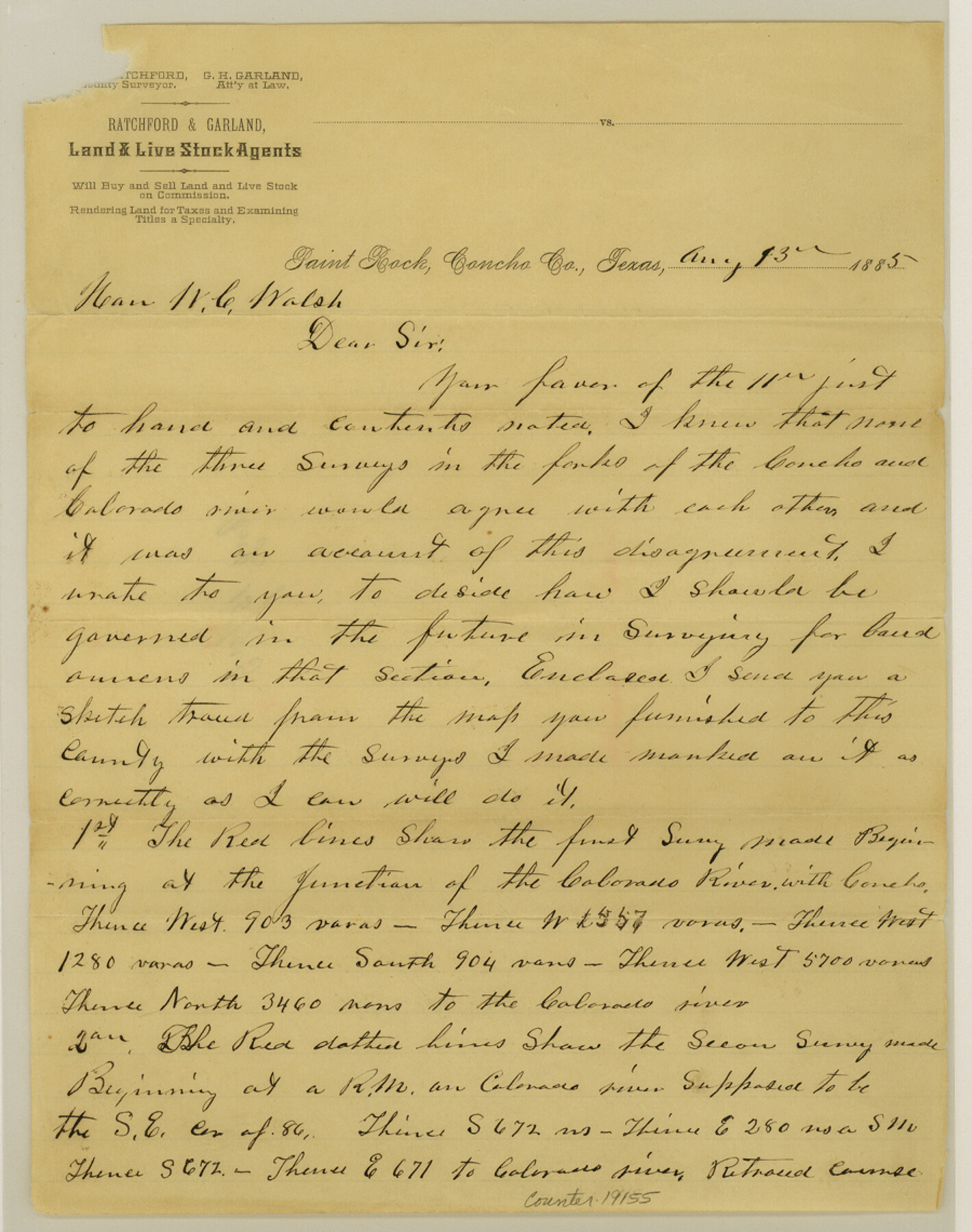
[Letter regarding surveys in the forks of the Concho and Colorado Rivers]
-
Map/Doc
19155
-
Collection
General Map Collection
-
Object Dates
1885/8/13 (Creation Date)
-
People and Organizations
J.W. Ratchford (Surveyor/Engineer)
-
Counties
Concho
-
Subjects
Surveying Sketch File
-
Height x Width
11.4 x 9.0 inches
29.0 x 22.9 cm
-
Medium
paper, manuscript
-
Features
Concho River
Colorado River
Part of: General Map Collection
Liberty County Working Sketch 36

Print $20.00
- Digital $50.00
Liberty County Working Sketch 36
1948
Size 24.3 x 25.0 inches
Map/Doc 70495
Hockley County Working Sketch 2

Print $20.00
- Digital $50.00
Hockley County Working Sketch 2
1960
Size 17.8 x 35.7 inches
Map/Doc 66192
Reeves County Working Sketch 65

Print $20.00
- Digital $50.00
Reeves County Working Sketch 65
1990
Size 17.3 x 19.7 inches
Map/Doc 63508
Wilbarger County Sketch File 23

Print $4.00
- Digital $50.00
Wilbarger County Sketch File 23
1887
Size 14.2 x 8.8 inches
Map/Doc 40223
Presidio County Working Sketch 94

Print $20.00
- Digital $50.00
Presidio County Working Sketch 94
1976
Size 40.6 x 32.1 inches
Map/Doc 71771
Llano County Working Sketch 7

Print $20.00
- Digital $50.00
Llano County Working Sketch 7
1968
Size 30.9 x 30.3 inches
Map/Doc 70625
Flight Mission No. CUG-2P, Frame 76, Kleberg County

Print $20.00
- Digital $50.00
Flight Mission No. CUG-2P, Frame 76, Kleberg County
1956
Size 18.4 x 22.1 inches
Map/Doc 86208
Medina County Rolled Sketch 3

Print $40.00
- Digital $50.00
Medina County Rolled Sketch 3
Size 40.9 x 54.5 inches
Map/Doc 9504
Maverick County Working Sketch 11

Print $20.00
- Digital $50.00
Maverick County Working Sketch 11
1965
Size 41.4 x 35.8 inches
Map/Doc 70903
Fannin County Sketch File 18

Print $20.00
- Digital $50.00
Fannin County Sketch File 18
1879
Size 16.7 x 22.2 inches
Map/Doc 11472
Flight Mission No. BRA-16M, Frame 107, Jefferson County

Print $20.00
- Digital $50.00
Flight Mission No. BRA-16M, Frame 107, Jefferson County
1953
Size 18.5 x 22.3 inches
Map/Doc 85719

You may also like
General Highway Map. Detail of Cities and Towns in Travis County, Texas. City Map, Austin and vicinity, Travis County, Texas

Print $20.00
General Highway Map. Detail of Cities and Towns in Travis County, Texas. City Map, Austin and vicinity, Travis County, Texas
1961
Size 24.8 x 18.1 inches
Map/Doc 79686
United States - Gulf Coast Texas - Northern part of Laguna Madre

Print $20.00
- Digital $50.00
United States - Gulf Coast Texas - Northern part of Laguna Madre
1941
Size 18.4 x 24.2 inches
Map/Doc 72936
Erath County Working Sketch 3

Print $20.00
- Digital $50.00
Erath County Working Sketch 3
1919
Size 17.6 x 17.6 inches
Map/Doc 69084
Culberson County Sketch File 17

Print $10.00
- Digital $50.00
Culberson County Sketch File 17
1932
Size 11.2 x 8.8 inches
Map/Doc 20180
Wilson County Working Sketch 6

Print $20.00
- Digital $50.00
Wilson County Working Sketch 6
1955
Size 39.4 x 32.3 inches
Map/Doc 72586
Jones County Rolled Sketch 4

Print $20.00
- Digital $50.00
Jones County Rolled Sketch 4
2022
Size 31.9 x 24.0 inches
Map/Doc 97150
Intracoastal Waterway in Texas - Corpus Christi to Point Isabel including Arroyo Colorado to Mo. Pac. R.R. Bridge Near Harlingen

Print $20.00
- Digital $50.00
Intracoastal Waterway in Texas - Corpus Christi to Point Isabel including Arroyo Colorado to Mo. Pac. R.R. Bridge Near Harlingen
1933
Size 28.2 x 40.7 inches
Map/Doc 61856
Garza County Sketch File F

Print $20.00
- Digital $50.00
Garza County Sketch File F
Size 9.8 x 18.9 inches
Map/Doc 11553
Map of Hardin County

Print $20.00
- Digital $50.00
Map of Hardin County
1902
Size 43.1 x 44.2 inches
Map/Doc 66854
Terry County Sketch File 13

Print $20.00
- Digital $50.00
Terry County Sketch File 13
Size 43.2 x 10.2 inches
Map/Doc 10397
Schleicher County

Print $20.00
- Digital $50.00
Schleicher County
1940
Size 28.8 x 41.2 inches
Map/Doc 77418
Hill County Sketch File 22a

Print $6.00
- Digital $50.00
Hill County Sketch File 22a
1861
Size 11.3 x 9.0 inches
Map/Doc 26509