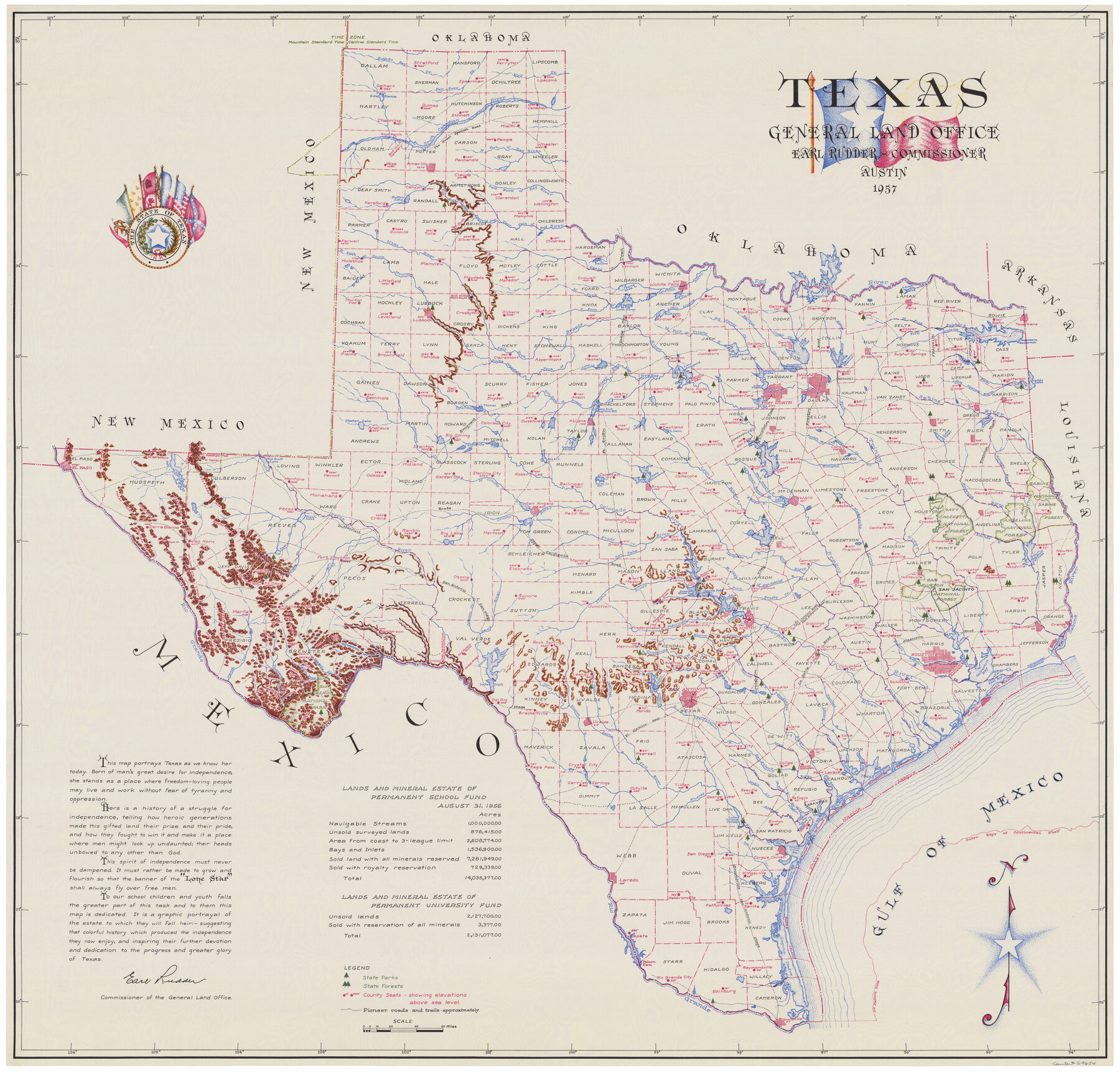
Texas
-
Map/Doc
69654
-
Collection
General Map Collection
-
Object Dates
1957 (Creation Date)
-
People and Organizations
General Land Office (Publisher)
J. Earl Rudder (GLO Commissioner)
[Eltea Armstrong] (Draftsman)
-
Subjects
State of Texas
-
Height x Width
33.5 x 35.0 inches
85.1 x 88.9 cm
-
Medium
paper, print
Part of: General Map Collection
Collingsworth County Rolled Sketch 2

Print $20.00
- Digital $50.00
Collingsworth County Rolled Sketch 2
1888
Size 30.2 x 24.8 inches
Map/Doc 5531
Sutton County Rolled Sketch 47

Print $20.00
- Digital $50.00
Sutton County Rolled Sketch 47
Size 17.0 x 24.3 inches
Map/Doc 7888
San Jacinto County Sketch File 9

Print $4.00
San Jacinto County Sketch File 9
1860
Size 8.7 x 11.7 inches
Map/Doc 35712
Val Verde County Rolled Sketch 65

Print $20.00
- Digital $50.00
Val Verde County Rolled Sketch 65
1956
Size 43.0 x 45.0 inches
Map/Doc 10083
Henderson County Sketch File 11

Print $2.00
- Digital $50.00
Henderson County Sketch File 11
Size 8.5 x 3.7 inches
Map/Doc 26348
Flight Mission No. CGI-3N, Frame 79, Cameron County

Print $20.00
- Digital $50.00
Flight Mission No. CGI-3N, Frame 79, Cameron County
1954
Size 18.6 x 22.4 inches
Map/Doc 84573
McLennan County Sketch File 4a

Print $6.00
- Digital $50.00
McLennan County Sketch File 4a
Size 9.2 x 7.9 inches
Map/Doc 31237
Sutton County Rolled Sketch 45

Print $20.00
- Digital $50.00
Sutton County Rolled Sketch 45
Size 39.1 x 47.2 inches
Map/Doc 9974
Mason County Sketch File 16

Print $5.00
- Digital $50.00
Mason County Sketch File 16
Size 9.1 x 11.2 inches
Map/Doc 30703
Fractional Township No. 8 South Range No. 15 East of the Indian Meridian, Indian Territory

Print $20.00
- Digital $50.00
Fractional Township No. 8 South Range No. 15 East of the Indian Meridian, Indian Territory
1896
Size 19.1 x 24.3 inches
Map/Doc 75227
Flight Mission No. CRC-3R, Frame 166, Chambers County

Print $20.00
- Digital $50.00
Flight Mission No. CRC-3R, Frame 166, Chambers County
1956
Size 18.8 x 22.4 inches
Map/Doc 84848
Port Facilities at Texas City, Tex.

Print $20.00
- Digital $50.00
Port Facilities at Texas City, Tex.
1924
Size 13.9 x 15.9 inches
Map/Doc 97161
You may also like
Flight Mission No. BRA-7M, Frame 197, Jefferson County

Print $20.00
- Digital $50.00
Flight Mission No. BRA-7M, Frame 197, Jefferson County
1953
Size 18.6 x 22.4 inches
Map/Doc 85565
Presidio County Sketch File 61

Print $3.00
- Digital $50.00
Presidio County Sketch File 61
1930
Size 9.3 x 15.4 inches
Map/Doc 89987
Resurvey of Block K-3

Print $20.00
- Digital $50.00
Resurvey of Block K-3
1913
Size 17.0 x 19.0 inches
Map/Doc 90540
Howard County Rolled Sketch 2

Print $20.00
- Digital $50.00
Howard County Rolled Sketch 2
1905
Size 27.6 x 23.0 inches
Map/Doc 6232
Cherokee County Working Sketch 24

Print $20.00
- Digital $50.00
Cherokee County Working Sketch 24
1972
Size 37.2 x 38.8 inches
Map/Doc 67979
Foard County Sketch File 12

Print $4.00
- Digital $50.00
Foard County Sketch File 12
1881
Size 11.0 x 8.5 inches
Map/Doc 22814
Hutchinson County Rolled Sketch 35

Print $20.00
- Digital $50.00
Hutchinson County Rolled Sketch 35
1934
Size 43.3 x 37.7 inches
Map/Doc 9245
Erath County Sketch File 15

Print $4.00
- Digital $50.00
Erath County Sketch File 15
1872
Size 6.2 x 7.6 inches
Map/Doc 22292
Wise County Working Sketch 11

Print $20.00
- Digital $50.00
Wise County Working Sketch 11
1958
Size 18.5 x 30.6 inches
Map/Doc 72625
Scurry County Rolled Sketch 3

Print $40.00
- Digital $50.00
Scurry County Rolled Sketch 3
Size 50.2 x 46.7 inches
Map/Doc 9912
Galveston County NRC Article 33.136 Sketch 82

Print $82.00
- Digital $50.00
Galveston County NRC Article 33.136 Sketch 82
2015
Size 24.0 x 36.0 inches
Map/Doc 94601
Travis County Appraisal District Plat Map 2_2512

Print $20.00
- Digital $50.00
Travis County Appraisal District Plat Map 2_2512
1938
Size 21.5 x 26.5 inches
Map/Doc 94216