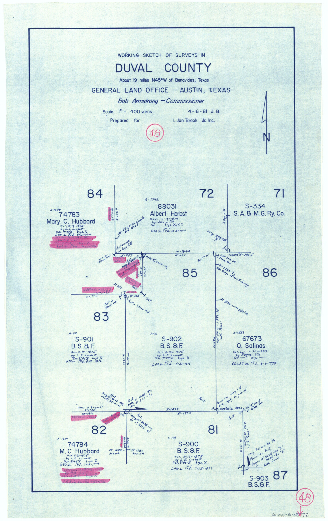
Duval County Working Sketch 48
-
Map/Doc
68772
-
Collection
General Map Collection
-
Object Dates
4/6/1981 (Creation Date)
-
People and Organizations
Jana Brod (Draftsman)
-
Counties
Duval
-
Subjects
Surveying Working Sketch
-
Height x Width
21.2 x 13.4 inches
53.9 x 34.0 cm
-
Scale
1" = 400 varas
Part of: General Map Collection
San Patricio County NRC Article 33.136 Sketch 1

Print $32.00
- Digital $50.00
San Patricio County NRC Article 33.136 Sketch 1
2001
Size 18.5 x 24.1 inches
Map/Doc 61623
Refugio County Working Sketch 3

Print $20.00
- Digital $50.00
Refugio County Working Sketch 3
1927
Size 21.9 x 24.6 inches
Map/Doc 63512
Fort Bend County Sketch File 5

Print $4.00
- Digital $50.00
Fort Bend County Sketch File 5
Size 8.2 x 13.0 inches
Map/Doc 22889
Terry County Rolled Sketch 9

Print $20.00
- Digital $50.00
Terry County Rolled Sketch 9
Size 23.8 x 23.9 inches
Map/Doc 7983
Pecos County Rolled Sketch 184

Print $20.00
- Digital $50.00
Pecos County Rolled Sketch 184
1977
Size 44.4 x 30.0 inches
Map/Doc 7303
Milam County Working Sketch 3

Print $20.00
- Digital $50.00
Milam County Working Sketch 3
Size 29.0 x 38.4 inches
Map/Doc 71018
Taylor County Sketch File A

Print $2.00
- Digital $50.00
Taylor County Sketch File A
Size 8.8 x 11.3 inches
Map/Doc 37773
Edwards County Working Sketch 136

Print $20.00
- Digital $50.00
Edwards County Working Sketch 136
1997
Size 18.4 x 25.4 inches
Map/Doc 69012
San Jacinto County Rolled Sketch 10B

Print $40.00
- Digital $50.00
San Jacinto County Rolled Sketch 10B
1944
Size 76.5 x 43.2 inches
Map/Doc 9883
Coast Chart No. 212 - From Latitude 26° 33' to the Rio Grande Texas

Print $20.00
- Digital $50.00
Coast Chart No. 212 - From Latitude 26° 33' to the Rio Grande Texas
1886
Size 27.7 x 18.2 inches
Map/Doc 72827
Northeast Part Pecos County

Print $20.00
- Digital $50.00
Northeast Part Pecos County
1975
Size 36.9 x 43.4 inches
Map/Doc 95611
Dimmit County Rolled Sketch 2

Print $20.00
- Digital $50.00
Dimmit County Rolled Sketch 2
Size 33.9 x 39.6 inches
Map/Doc 8793
You may also like
Stonewall County Sketch File B1

Print $20.00
- Digital $50.00
Stonewall County Sketch File B1
1901
Size 36.2 x 34.9 inches
Map/Doc 10379
Map of the Houston and G. N. R.R. and lands adjacent, from Troupe to the Texas Pacific R.R.

Print $40.00
- Digital $50.00
Map of the Houston and G. N. R.R. and lands adjacent, from Troupe to the Texas Pacific R.R.
Size 21.2 x 92.0 inches
Map/Doc 64627
Catalogue of the Spanish Collection of the Texas General Land Office

Digital $15.00
Catalogue of the Spanish Collection of the Texas General Land Office
2003
Size 10.8 x 8.5 inches
Map/Doc 83387
Map of Dallas County Showing Location of Texas and Pacific Railway

Print $20.00
- Digital $50.00
Map of Dallas County Showing Location of Texas and Pacific Railway
1872
Size 25.2 x 21.4 inches
Map/Doc 64134
Chart of soundings through the different channels in Aransas and Matagorda Bays as taken in 1855 by Capt. R. B. Marey, U. S. A. [Inset: Harbour of Lamar and Live-Oak Pt.]
![72978, Chart of soundings through the different channels in Aransas and Matagorda Bays as taken in 1855 by Capt. R. B. Marey, U. S. A. [Inset: Harbour of Lamar and Live-Oak Pt.], General Map Collection](https://historictexasmaps.com/wmedia_w700/maps/72978.tif.jpg)
Print $20.00
- Digital $50.00
Chart of soundings through the different channels in Aransas and Matagorda Bays as taken in 1855 by Capt. R. B. Marey, U. S. A. [Inset: Harbour of Lamar and Live-Oak Pt.]
Size 28.4 x 18.3 inches
Map/Doc 72978

Maps of Gulf Intracoastal Waterway, Texas - Sabine River to the Rio Grande and connecting waterways including ship channels

Print $20.00
- Digital $50.00
Maps of Gulf Intracoastal Waterway, Texas - Sabine River to the Rio Grande and connecting waterways including ship channels
1966
Size 14.6 x 22.3 inches
Map/Doc 61916
Brazos River, Sugarland Sheet

Print $20.00
- Digital $50.00
Brazos River, Sugarland Sheet
1938
Size 31.0 x 40.6 inches
Map/Doc 65288
El Paso County Boundary File 26

Print $14.00
- Digital $50.00
El Paso County Boundary File 26
Size 14.8 x 9.3 inches
Map/Doc 53231
[E. L. & R. R. Block 10]
![91353, [E. L. & R. R. Block 10], Twichell Survey Records](https://historictexasmaps.com/wmedia_w700/maps/91353-1.tif.jpg)
Print $20.00
- Digital $50.00
[E. L. & R. R. Block 10]
Size 25.3 x 16.5 inches
Map/Doc 91353
Map of Texas and Pacific Ry. Company's Surveys in the 80 Mile Reserve

Print $40.00
- Digital $50.00
Map of Texas and Pacific Ry. Company's Surveys in the 80 Mile Reserve
1885
Size 41.5 x 91.8 inches
Map/Doc 2300
General Highway Map. Detail of Cities and Towns in McLennan County, Texas

Print $20.00
General Highway Map. Detail of Cities and Towns in McLennan County, Texas
1961
Size 18.2 x 24.6 inches
Map/Doc 79591