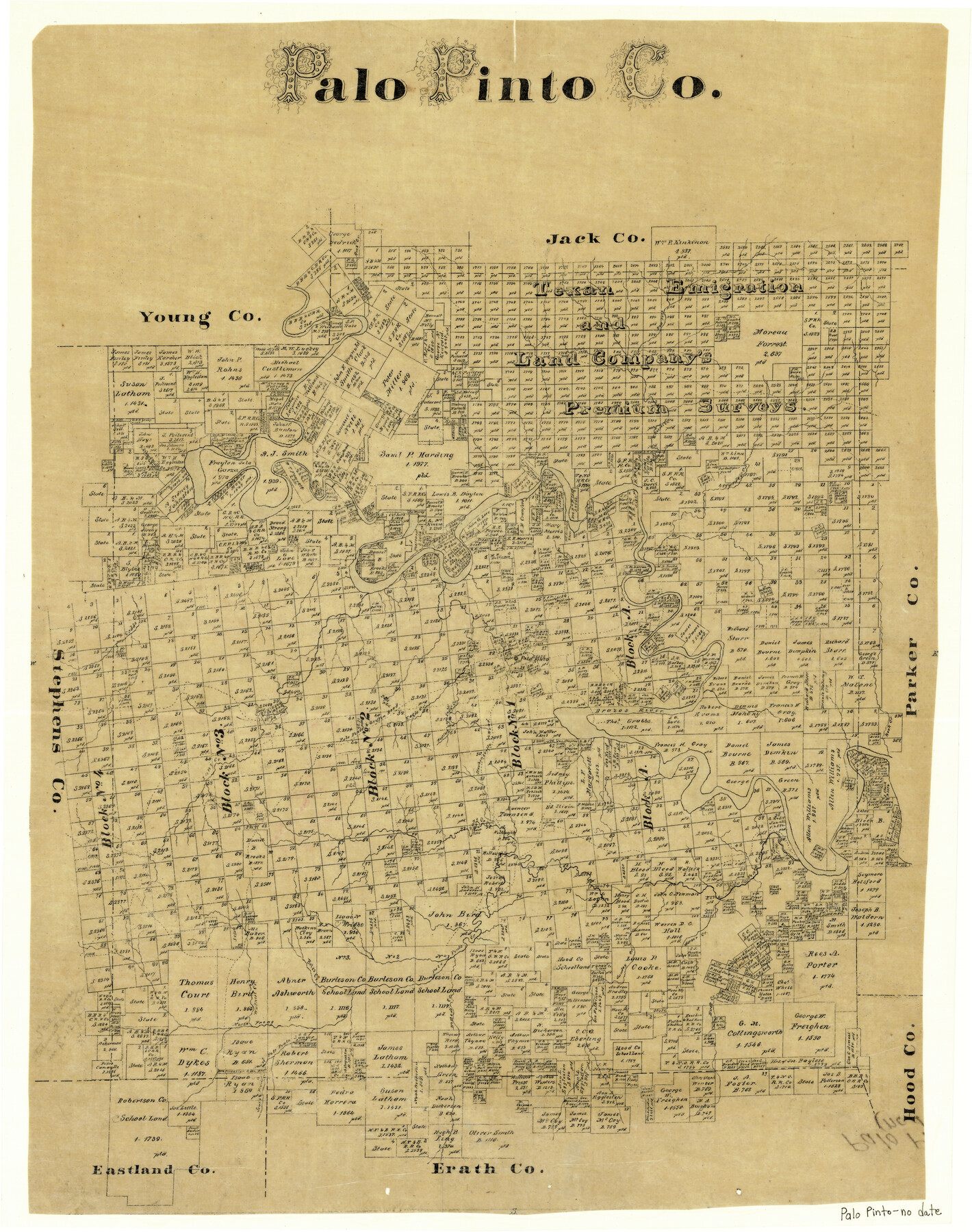
Palo Pinto County
-
Map/Doc
3936
-
Collection
General Map Collection
-
Counties
Palo Pinto
-
Subjects
County
-
Height x Width
23.7 x 18.6 inches
60.2 x 47.2 cm
-
Medium
paper, etching/engraving/lithograph
-
Features
[Fort] Griffin Road
Lone Creek
Palo Pinto & Griffin Road
Buck Creek
Bartons Creek
South Prong [of Palo Pinto Creek]
North Prong of Palo Pinto Creek
Walnut Creek
Boles Creek
Sunday Creek
Warser Creek
Palo Pinto Creek
Ioni Creek
Rock Creek
Palo Pinto Road
West Fork of Eagle Creek
Eagle Creek
Stephensville Road
Palo Pinto
Brazos River
Caddo Creek
Turkey Creek
Keechi Creek
Cedar Bluff Creek
East Fork [of Keechi Creek]
Part of: General Map Collection
Denton County Sketch File 41

Print $6.00
- Digital $50.00
Denton County Sketch File 41
1883
Size 12.8 x 8.5 inches
Map/Doc 20789
Collingsworth County Rolled Sketch 1

Print $40.00
- Digital $50.00
Collingsworth County Rolled Sketch 1
1941
Size 54.2 x 24.0 inches
Map/Doc 9664
Washington County

Print $40.00
- Digital $50.00
Washington County
1920
Size 33.5 x 48.8 inches
Map/Doc 1900
Map of Kinney County

Print $20.00
- Digital $50.00
Map of Kinney County
1876
Size 24.0 x 32.4 inches
Map/Doc 3775
Sutton County Sketch File 36a

Print $61.00
- Digital $50.00
Sutton County Sketch File 36a
Size 9.0 x 9.0 inches
Map/Doc 37472
Brewster County Rolled Sketch 114

Print $20.00
- Digital $50.00
Brewster County Rolled Sketch 114
1964
Size 11.9 x 18.4 inches
Map/Doc 5279
Clay County Sketch File 15

Print $4.00
- Digital $50.00
Clay County Sketch File 15
1873
Size 12.8 x 8.4 inches
Map/Doc 18419
Trinity County Rolled Sketch 6

Print $20.00
- Digital $50.00
Trinity County Rolled Sketch 6
1999
Size 25.0 x 19.3 inches
Map/Doc 8053
Val Verde County Rolled Sketch 81

Print $20.00
- Digital $50.00
Val Verde County Rolled Sketch 81
Size 35.0 x 44.7 inches
Map/Doc 10088
Presidio County Rolled Sketch 65

Print $20.00
- Digital $50.00
Presidio County Rolled Sketch 65
Size 23.1 x 28.3 inches
Map/Doc 7356
Gulf Oil Corp. Fishgide - Port O'Connor

Gulf Oil Corp. Fishgide - Port O'Connor
1960
Size 12.0 x 22.0 inches
Map/Doc 75982
Liberty County Working Sketch 60

Print $20.00
- Digital $50.00
Liberty County Working Sketch 60
1969
Size 41.3 x 34.1 inches
Map/Doc 70520
You may also like
Garza County Working Sketch 3

Print $20.00
- Digital $50.00
Garza County Working Sketch 3
1919
Size 13.8 x 14.0 inches
Map/Doc 63150
Map Showing Present Owners on the Elizabeth Standifer, James Standifer, Jacob Standifer, C. A. West and William Standifer Original Surveys in Bastrop County, Texas

Print $20.00
- Digital $50.00
Map Showing Present Owners on the Elizabeth Standifer, James Standifer, Jacob Standifer, C. A. West and William Standifer Original Surveys in Bastrop County, Texas
1915
Size 22.2 x 31.5 inches
Map/Doc 90152
Shelby County Sketch File 11

Print $50.00
- Digital $50.00
Shelby County Sketch File 11
1859
Size 8.8 x 7.0 inches
Map/Doc 36613
Flight Mission No. BQY-4M, Frame 116, Harris County

Print $20.00
- Digital $50.00
Flight Mission No. BQY-4M, Frame 116, Harris County
1953
Size 18.5 x 22.4 inches
Map/Doc 85283
General Highway Map, Bexar County, Texas

Print $20.00
General Highway Map, Bexar County, Texas
1940
Size 18.4 x 25.1 inches
Map/Doc 76287
[Cotton Belt, St. Louis Southwestern Railway of Texas, Alignment through Smith County]
![64375, [Cotton Belt, St. Louis Southwestern Railway of Texas, Alignment through Smith County], General Map Collection](https://historictexasmaps.com/wmedia_w700/maps/64375.tif.jpg)
Print $20.00
- Digital $50.00
[Cotton Belt, St. Louis Southwestern Railway of Texas, Alignment through Smith County]
1903
Size 21.3 x 28.5 inches
Map/Doc 64375
Tarrant County Sketch File 28

Print $4.00
- Digital $50.00
Tarrant County Sketch File 28
1876
Size 8.0 x 8.0 inches
Map/Doc 37743
Pecos County Rolled Sketch 19

Print $21.00
- Digital $50.00
Pecos County Rolled Sketch 19
1885
Size 9.4 x 14.7 inches
Map/Doc 48082
Knox County Sketch File 22

Print $6.00
- Digital $50.00
Knox County Sketch File 22
1931
Size 11.2 x 8.8 inches
Map/Doc 29251
Jackson County Rolled Sketch 15

Print $40.00
- Digital $50.00
Jackson County Rolled Sketch 15
1945
Size 53.7 x 30.3 inches
Map/Doc 9261
Flight Mission No. BQY-4M, Frame 60, Harris County

Print $20.00
- Digital $50.00
Flight Mission No. BQY-4M, Frame 60, Harris County
1953
Size 18.6 x 22.3 inches
Map/Doc 85269
Cameron County Sketch File 13

Print $50.00
- Digital $50.00
Cameron County Sketch File 13
Size 11.0 x 8.5 inches
Map/Doc 17298