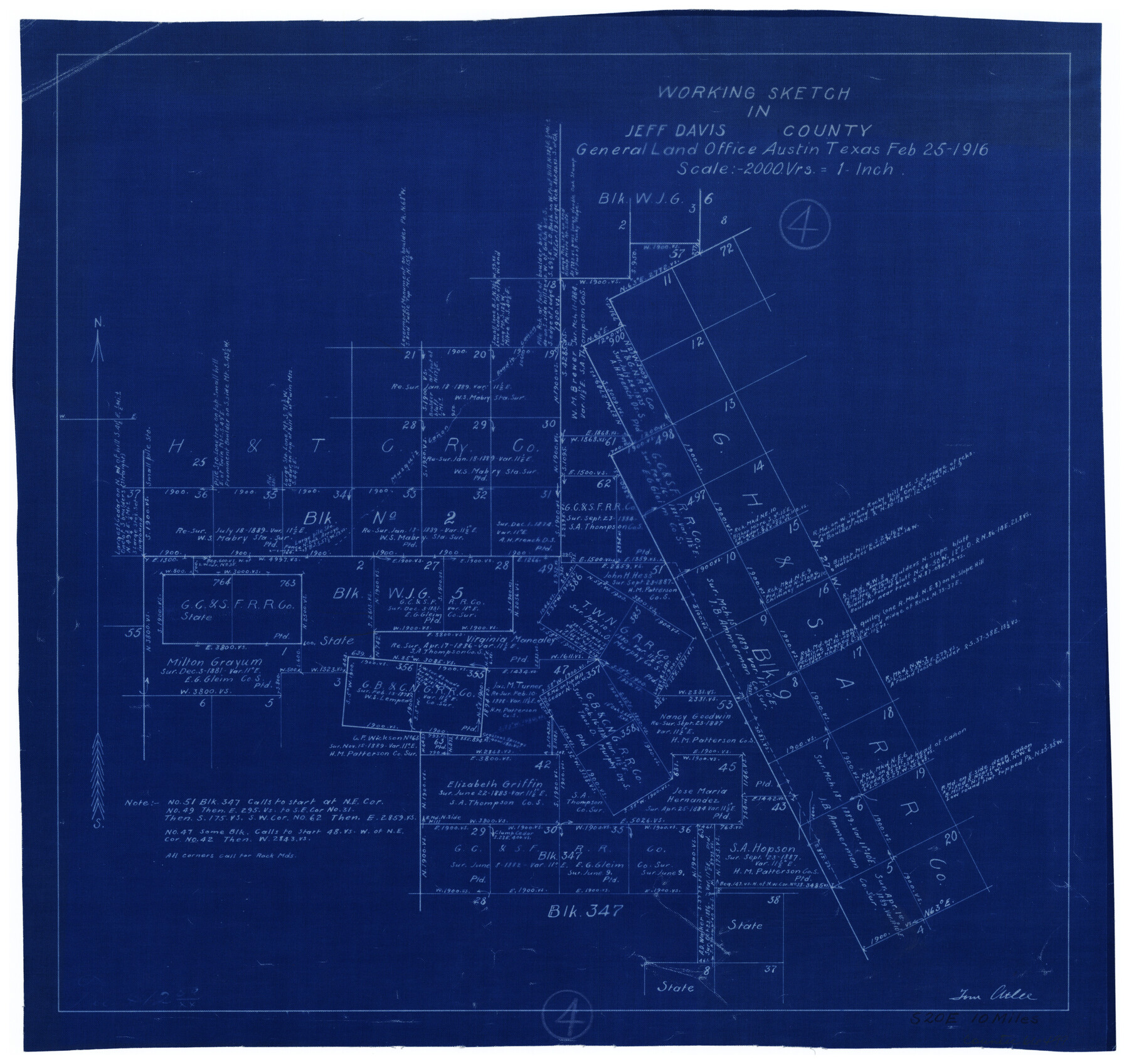
Jeff Davis County Working Sketch 4
-
Map/Doc
66499
-
Collection
General Map Collection
-
Object Dates
2/25/1916 (Creation Date)
-
People and Organizations
Tom Atlee (Draftsman)
-
Counties
Jeff Davis
-
Subjects
Surveying Working Sketch
-
Height x Width
14.3 x 15.2 inches
36.3 x 38.6 cm
-
Scale
1" = 2000 varas
Part of: General Map Collection
Flight Mission No. BRA-6M, Frame 152, Jefferson County

Print $20.00
- Digital $50.00
Flight Mission No. BRA-6M, Frame 152, Jefferson County
1953
Size 18.6 x 22.3 inches
Map/Doc 85453
St. Louis, Brownsville & Mexico Railway Location map from Mile 40 to Mile 60

Print $40.00
- Digital $50.00
St. Louis, Brownsville & Mexico Railway Location map from Mile 40 to Mile 60
1905
Size 19.6 x 74.9 inches
Map/Doc 64079
Coast Chart No. 210 - Aransas Pass and Corpus Christi Bay with the coast to latitude 27° 12', Texas

Print $20.00
- Digital $50.00
Coast Chart No. 210 - Aransas Pass and Corpus Christi Bay with the coast to latitude 27° 12', Texas
1907
Size 44.2 x 36.5 inches
Map/Doc 73449
Reagan County Rolled Sketch 14

Print $20.00
- Digital $50.00
Reagan County Rolled Sketch 14
1942
Size 19.8 x 21.2 inches
Map/Doc 7442
Culberson County Sketch File 36

Print $28.00
- Digital $50.00
Culberson County Sketch File 36
1957
Size 11.3 x 8.7 inches
Map/Doc 20302
Flight Mission No. DIX-8P, Frame 89, Aransas County

Print $20.00
- Digital $50.00
Flight Mission No. DIX-8P, Frame 89, Aransas County
1956
Size 18.7 x 22.4 inches
Map/Doc 83914
Rusk County Sketch File 34

Print $20.00
Rusk County Sketch File 34
1949
Size 33.4 x 28.2 inches
Map/Doc 10597
Brewster County Rolled Sketch 148B

Print $20.00
- Digital $50.00
Brewster County Rolled Sketch 148B
1994
Size 28.0 x 36.3 inches
Map/Doc 5315
Map of Central Europe engraved to illustrate Mitchell's new intermediate geography

Print $20.00
- Digital $50.00
Map of Central Europe engraved to illustrate Mitchell's new intermediate geography
1885
Size 9.0 x 12.2 inches
Map/Doc 93528
Liberty County Sketch File B

Print $4.00
- Digital $50.00
Liberty County Sketch File B
1869
Size 12.0 x 8.2 inches
Map/Doc 30066
Map of Austin's Li[ttle Colony Above the] San [Antonio Road]
![215, Map of Austin's Li[ttle Colony Above the] San [Antonio Road], General Map Collection](https://historictexasmaps.com/wmedia_w700/maps/215.tif.jpg)
Print $20.00
- Digital $50.00
Map of Austin's Li[ttle Colony Above the] San [Antonio Road]
1831
Size 14.2 x 19.3 inches
Map/Doc 215
Delta County Sketch File 5

Print $2.00
- Digital $50.00
Delta County Sketch File 5
1886
Size 14.6 x 8.6 inches
Map/Doc 20676
You may also like
Williamson County Working Sketch 19

Print $20.00
- Digital $50.00
Williamson County Working Sketch 19
1991
Size 31.2 x 40.0 inches
Map/Doc 72579
University Lands Blocks 38 to 57, Crockett-Reagan-Irion-Schleicher-Counties

Print $40.00
- Digital $50.00
University Lands Blocks 38 to 57, Crockett-Reagan-Irion-Schleicher-Counties
1937
Size 34.2 x 52.7 inches
Map/Doc 2444
Flight Mission No. DQN-7K, Frame 88, Calhoun County

Print $20.00
- Digital $50.00
Flight Mission No. DQN-7K, Frame 88, Calhoun County
1953
Size 18.5 x 22.1 inches
Map/Doc 84479
Flight Mission No. CRC-4R, Frame 176, Chambers County

Print $20.00
- Digital $50.00
Flight Mission No. CRC-4R, Frame 176, Chambers County
1956
Size 18.6 x 22.3 inches
Map/Doc 84927
Flight Mission No. BRE-1P, Frame 51, Nueces County

Print $20.00
- Digital $50.00
Flight Mission No. BRE-1P, Frame 51, Nueces County
1956
Size 18.3 x 22.2 inches
Map/Doc 86640
Brewster County Rolled Sketch 75

Print $20.00
- Digital $50.00
Brewster County Rolled Sketch 75
1941
Size 31.5 x 36.9 inches
Map/Doc 8492
Flight Mission No. CGI-1N, Frame 215, Cameron County

Print $20.00
- Digital $50.00
Flight Mission No. CGI-1N, Frame 215, Cameron County
1955
Size 18.5 x 22.1 inches
Map/Doc 84524
Burnet County Sketch File 5

Print $4.00
- Digital $50.00
Burnet County Sketch File 5
Size 6.9 x 8.0 inches
Map/Doc 16680
Montgomery County Rolled Sketch 14

Print $20.00
- Digital $50.00
Montgomery County Rolled Sketch 14
Size 22.4 x 25.4 inches
Map/Doc 6803
Maverick County Sketch File 24

Print $36.00
- Digital $50.00
Maverick County Sketch File 24
1890
Size 9.1 x 8.7 inches
Map/Doc 31145
Burnet County Working Sketch 23

Print $40.00
- Digital $50.00
Burnet County Working Sketch 23
1987
Size 43.8 x 51.9 inches
Map/Doc 67866
Cameron County Working Sketch Graphic Index

Print $20.00
- Digital $50.00
Cameron County Working Sketch Graphic Index
1976
Size 32.0 x 39.4 inches
Map/Doc 76486