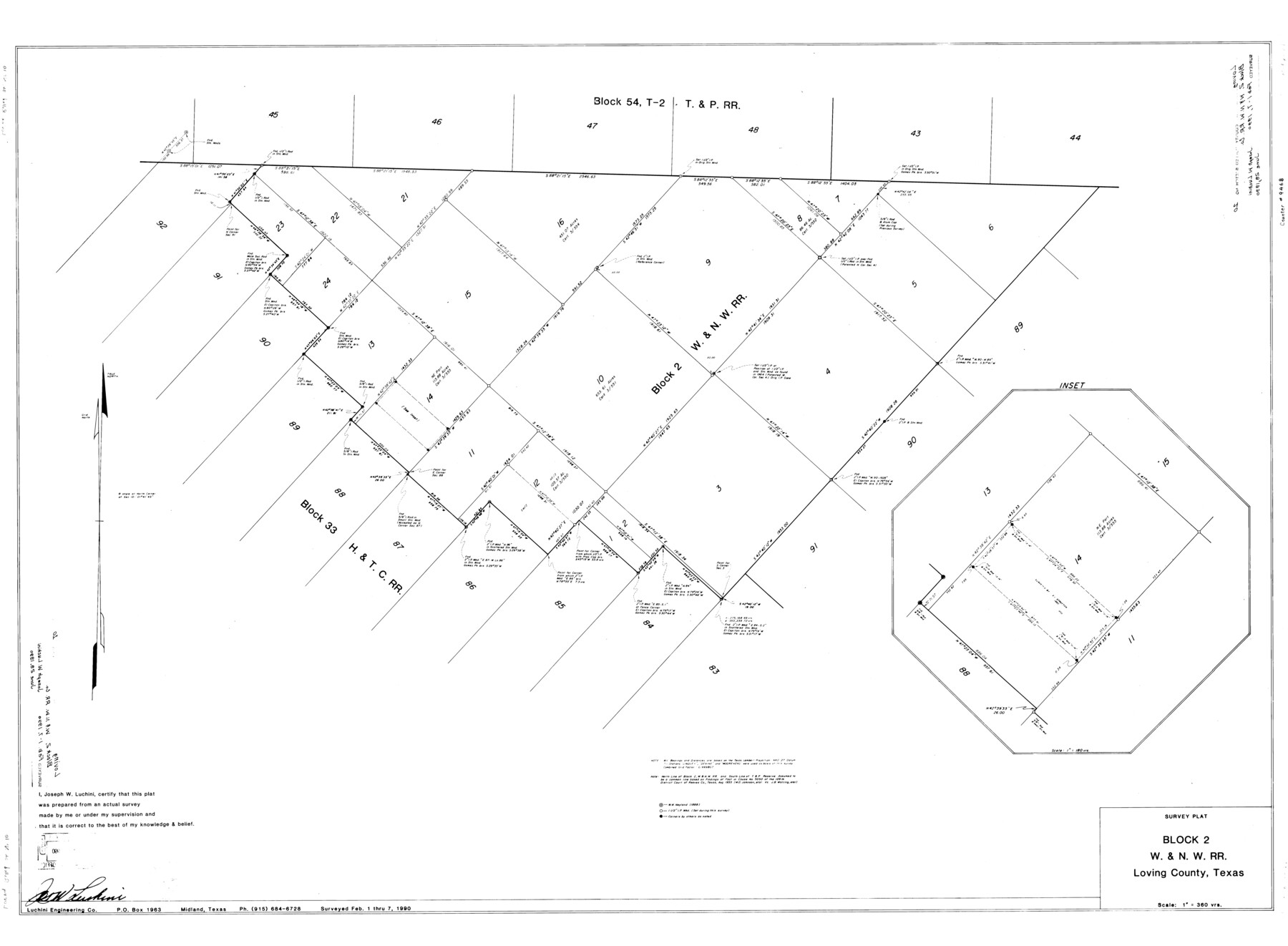
Loving County Rolled Sketch 10
Survey plat, Block 2, W. & N. W. R.R., Loving County, Texas
-
Map/Doc
9468
-
Collection
General Map Collection
-
Object Dates
1990/2/7 (Creation Date)
1990/6/28 (File Date)
-
People and Organizations
Joseph W. Luchini (Surveyor/Engineer)
-
Counties
Loving
-
Subjects
Surveying Rolled Sketch
-
Height x Width
32.0 x 43.6 inches
81.3 x 110.7 cm
-
Medium
mylar, print
-
Scale
1" = 360 varas
Part of: General Map Collection
Right of Way and Track Map, International & Gt. Northern Ry. operated by the International & Gt. Northern Ry. Co. Gulf Division, Mineola Branch

Print $40.00
- Digital $50.00
Right of Way and Track Map, International & Gt. Northern Ry. operated by the International & Gt. Northern Ry. Co. Gulf Division, Mineola Branch
1917
Size 25.4 x 121.1 inches
Map/Doc 64702
Zavala County Sketch File 44

Print $25.00
- Digital $50.00
Zavala County Sketch File 44
1915
Size 10.1 x 14.3 inches
Map/Doc 41416
Jack County Sketch File 5

Print $6.00
- Digital $50.00
Jack County Sketch File 5
1875
Size 11.0 x 10.8 inches
Map/Doc 27508
[Copy from Harris County map]
![78371, [Copy from Harris County map], General Map Collection](https://historictexasmaps.com/wmedia_w700/maps/78371.tif.jpg)
Print $2.00
- Digital $50.00
[Copy from Harris County map]
Size 7.4 x 3.9 inches
Map/Doc 78371
Shelby County Sketch File 20

Print $20.00
- Digital $50.00
Shelby County Sketch File 20
1879
Size 18.3 x 34.6 inches
Map/Doc 12319
Flight Mission No. DCL-7C, Frame 137, Kenedy County

Print $20.00
- Digital $50.00
Flight Mission No. DCL-7C, Frame 137, Kenedy County
1943
Size 15.4 x 15.3 inches
Map/Doc 86094
Shelby County Rolled Sketch 2

Print $20.00
- Digital $50.00
Shelby County Rolled Sketch 2
Size 20.3 x 30.7 inches
Map/Doc 7775
Karte des Staates, Texas

Print $20.00
- Digital $50.00
Karte des Staates, Texas
1851
Size 25.5 x 30.8 inches
Map/Doc 2123
Jefferson County Working Sketch 22

Print $20.00
- Digital $50.00
Jefferson County Working Sketch 22
1969
Size 22.2 x 38.0 inches
Map/Doc 66565
Aransas County Aerial Photograph Index Sheet 2

Print $20.00
- Digital $50.00
Aransas County Aerial Photograph Index Sheet 2
1957
Size 23.0 x 17.9 inches
Map/Doc 83660
Flight Mission No. BRE-1P, Frame 114, Nueces County

Print $20.00
- Digital $50.00
Flight Mission No. BRE-1P, Frame 114, Nueces County
1956
Size 18.6 x 22.9 inches
Map/Doc 86680
Kimble County Working Sketch 75

Print $20.00
- Digital $50.00
Kimble County Working Sketch 75
1968
Size 32.0 x 35.7 inches
Map/Doc 70143
You may also like
Jefferson County Sketch File 22

Print $22.00
- Digital $50.00
Jefferson County Sketch File 22
Size 7.6 x 11.9 inches
Map/Doc 28179
Edwards County Sketch File 13

Print $6.00
- Digital $50.00
Edwards County Sketch File 13
1888
Size 11.1 x 7.1 inches
Map/Doc 21700
Trinity County Sketch File 10

Print $8.00
- Digital $50.00
Trinity County Sketch File 10
1858
Size 13.1 x 8.0 inches
Map/Doc 38527
Terrell County Rolled Sketch 24

Print $20.00
- Digital $50.00
Terrell County Rolled Sketch 24
Size 19.7 x 25.7 inches
Map/Doc 7931
Stonewall County Rolled Sketch 36B

Print $20.00
- Digital $50.00
Stonewall County Rolled Sketch 36B
Size 35.2 x 22.8 inches
Map/Doc 76404
Fort Bend County Sketch File 4

Print $4.00
- Digital $50.00
Fort Bend County Sketch File 4
1876
Size 10.0 x 8.4 inches
Map/Doc 22885
Henderson County Working Sketch 18

Print $20.00
- Digital $50.00
Henderson County Working Sketch 18
1941
Size 23.8 x 23.4 inches
Map/Doc 66151
Plano del Presidio de Nra Senora del Pilar de los Adaes

Plano del Presidio de Nra Senora del Pilar de los Adaes
1766
Size 7.3 x 9.2 inches
Map/Doc 96517
Jackson County Sketch File 4

Print $20.00
- Digital $50.00
Jackson County Sketch File 4
Size 18.2 x 22.7 inches
Map/Doc 11834
Travis County Appraisal District Plat Map 1_1808

Print $20.00
- Digital $50.00
Travis County Appraisal District Plat Map 1_1808
Size 21.5 x 26.5 inches
Map/Doc 94214
Throckmorton County

Print $20.00
- Digital $50.00
Throckmorton County
1943
Size 46.7 x 37.4 inches
Map/Doc 95653
Crockett County Sketch File 58a

Print $20.00
- Digital $50.00
Crockett County Sketch File 58a
1923
Size 21.1 x 25.8 inches
Map/Doc 5601