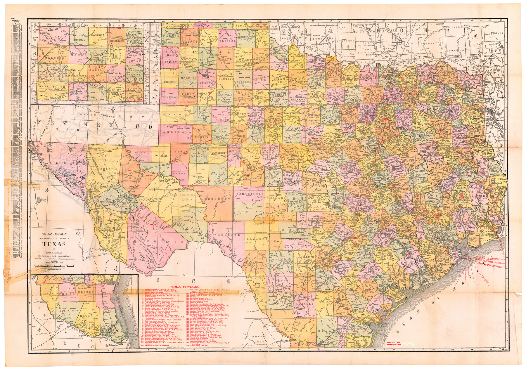
The Rand McNally New Commercial Atlas Map of Texas
[Inset 1: Panhandle] / [Inset 2: Southern Portion of Texas]
-
Map/Doc
95850
-
Collection
Cobb Digital Map Collection
-
Object Dates
[1917] (Creation Date)
-
People and Organizations
Rand, McNally & Co. (Publisher)
-
Subjects
Railroads State of Texas
-
Height x Width
28.7 x 40.6 inches
72.9 x 103.1 cm
-
Medium
digital image
-
Scale
1" = 20 statute miles
-
Comments
Courtesy of John & Diana Cobb.
To view small "Texas Automobile Road Map printed on verso and full booklet containing this map, click "Download PDF" link above.
Part of: Cobb Digital Map Collection

Corpus Christi, Where Texas Meets the Sea

Corpus Christi, Where Texas Meets the Sea
1927
Size 9.6 x 4.3 inches
Map/Doc 97064
Along the Sunset Route, Southern Pacific Lines - Texas and Louisiana

Along the Sunset Route, Southern Pacific Lines - Texas and Louisiana
1947
Map/Doc 96720
A Little Journey through the Lower Valley of the Rio Grande - The Magic Valley of Texas

A Little Journey through the Lower Valley of the Rio Grande - The Magic Valley of Texas
1928
Map/Doc 96741
Buffalo Bayou and the Houston Ship Channel 1820-1926

Buffalo Bayou and the Houston Ship Channel 1820-1926
1926
Size 6.2 x 9.1 inches
Map/Doc 97071

Sectional map of Texas traversed by the Missouri, Kansas & Texas Railway, showing the crops adapted to each section, with the elevation and annual rainfall

Print $20.00
- Digital $50.00
Sectional map of Texas traversed by the Missouri, Kansas & Texas Railway, showing the crops adapted to each section, with the elevation and annual rainfall
1904
Size 21.9 x 22.6 inches
Map/Doc 95813
El Paso and the New Southwest

El Paso and the New Southwest
1923
Size 11.8 x 9.0 inches
Map/Doc 97047
A Little Journey through the Lower Valley of the Rio Grande - The Magic Valley of Texas

A Little Journey through the Lower Valley of the Rio Grande - The Magic Valley of Texas
1929
Map/Doc 96742
[Map 1:] A Geographically Correct County Map of States Traversed by the St. Louis, Iron Mountain and Southern Railway and its connections / [Map 2:] Map of the St. Louis, Iron Mountain and Southern Railway, and connections
![95784, [Map 1:] A Geographically Correct County Map of States Traversed by the St. Louis, Iron Mountain and Southern Railway and its connections / [Map 2:] Map of the St. Louis, Iron Mountain and Southern Railway, and connections, Cobb Digital Map Collection - 1](https://historictexasmaps.com/wmedia_w700/maps/95784.tif.jpg)
Print $20.00
- Digital $50.00
[Map 1:] A Geographically Correct County Map of States Traversed by the St. Louis, Iron Mountain and Southern Railway and its connections / [Map 2:] Map of the St. Louis, Iron Mountain and Southern Railway, and connections
1878
Size 18.9 x 32.2 inches
Map/Doc 95784
Map of the Great Air Line Route, Ohio & Mississippi Railway and connections

Print $20.00
- Digital $50.00
Map of the Great Air Line Route, Ohio & Mississippi Railway and connections
1878
Size 12.8 x 26.4 inches
Map/Doc 95820

You may also like

General Highway Map. Detail of Cities and Towns in Nacogdoches County, Texas [Nacogdoches and vicinity]
![79609, General Highway Map. Detail of Cities and Towns in Nacogdoches County, Texas [Nacogdoches and vicinity], Texas State Library and Archives](https://historictexasmaps.com/wmedia_w700/maps/79609.tif.jpg)
Print $20.00
General Highway Map. Detail of Cities and Towns in Nacogdoches County, Texas [Nacogdoches and vicinity]
1961
Size 19.3 x 25.0 inches
Map/Doc 79609
[Surveys in Austin's Colony along the east bank of the Navidad River]
![78488, [Surveys in Austin's Colony along the east bank of the Navidad River], General Map Collection](https://historictexasmaps.com/wmedia_w700/maps/78488.tif.jpg)
Print $20.00
- Digital $50.00
[Surveys in Austin's Colony along the east bank of the Navidad River]
1827
Size 20.3 x 16.1 inches
Map/Doc 78488
Webb County Working Sketch 68

Print $40.00
- Digital $50.00
Webb County Working Sketch 68
1967
Size 31.6 x 50.7 inches
Map/Doc 72435
Starr County Sketch File 37

Print $10.00
- Digital $50.00
Starr County Sketch File 37
1940
Size 2.7 x 8.8 inches
Map/Doc 36980
Ward County Rolled Sketch 24F

Print $40.00
- Digital $50.00
Ward County Rolled Sketch 24F
Size 30.5 x 65.2 inches
Map/Doc 78232
Orange County Working Sketch Graphic Index - sheet A

Print $20.00
- Digital $50.00
Orange County Working Sketch Graphic Index - sheet A
1921
Size 24.4 x 29.3 inches
Map/Doc 76658
Fannin County Sketch File 12

Print $4.00
- Digital $50.00
Fannin County Sketch File 12
Size 8.4 x 6.5 inches
Map/Doc 22460
The Peters Colony. January 29, 1844

Print $20.00
The Peters Colony. January 29, 1844
2020
Size 17.2 x 21.7 inches
Map/Doc 96366
Calhoun County Rolled Sketch 14

Print $20.00
- Digital $50.00
Calhoun County Rolled Sketch 14
Size 22.1 x 40.6 inches
Map/Doc 5460
Jackson County Sketch File 3

Print $34.00
- Digital $50.00
Jackson County Sketch File 3
1875
Size 7.9 x 7.7 inches
Map/Doc 27621
Township 4 South Ranges 12 and 13 West, South Western District, Louisiana

Print $20.00
- Digital $50.00
Township 4 South Ranges 12 and 13 West, South Western District, Louisiana
1879
Size 19.6 x 24.7 inches
Map/Doc 65884