Trinity County Working Sketch 24

Print $20.00
- Digital $50.00
Trinity County Working Sketch 24
2010
Size: 18.2 x 36.5 inches
89599
Trinity County Working Sketch 26

Print $20.00
- Digital $50.00
Trinity County Working Sketch 26
2010
Size: 21.0 x 34.1 inches
89601
Trinity County Working Sketch 25

Print $20.00
- Digital $50.00
Trinity County Working Sketch 25
2010
Size: 39.7 x 28.7 inches
89600
Trinity County Working Sketch 27

Print $20.00
- Digital $50.00
Trinity County Working Sketch 27
2010
Size: 26.8 x 36.8 inches
90069
Trinity County Working Sketch 23

Print $20.00
- Digital $50.00
Trinity County Working Sketch 23
2010
Size: 23.4 x 33.6 inches
89259
Trinity County Working Sketch 22

Print $40.00
- Digital $50.00
Trinity County Working Sketch 22
2009
Size: 32.0 x 52.1 inches
89068
Trinity County Rolled Sketch 7

Print $20.00
- Digital $50.00
Trinity County Rolled Sketch 7
1999
Size: 24.8 x 36.3 inches
8054
Trinity County Rolled Sketch 6

Print $20.00
- Digital $50.00
Trinity County Rolled Sketch 6
1999
Size: 25.0 x 19.3 inches
8053
Trinity County Rolled Sketch 5

Print $20.00
- Digital $50.00
Trinity County Rolled Sketch 5
1993
Size: 25.3 x 38.0 inches
8052
Trinity County Sketch File 44

Print $8.00
- Digital $50.00
Trinity County Sketch File 44
1993
Size: 11.3 x 9.0 inches
38599
Trinity County Working Sketch 21

Print $20.00
- Digital $50.00
Trinity County Working Sketch 21
1992
Size: 23.1 x 23.1 inches
69470
Polk County Working Sketch 42

Print $20.00
- Digital $50.00
Polk County Working Sketch 42
1992
Size: 30.8 x 35.7 inches
71659
Trinity County Working Sketch 18

Print $20.00
- Digital $50.00
Trinity County Working Sketch 18
1982
Size: 13.4 x 11.1 inches
69467
Trinity County Working Sketch 19

Print $20.00
- Digital $50.00
Trinity County Working Sketch 19
1982
Size: 14.7 x 11.1 inches
69468
Trinity County Working Sketch 17

Print $20.00
- Digital $50.00
Trinity County Working Sketch 17
1978
Size: 24.0 x 26.6 inches
69466
Trinity County Working Sketch 16

Print $20.00
- Digital $50.00
Trinity County Working Sketch 16
1978
Size: 31.7 x 41.2 inches
69465
Trinity County Working Sketch 15

Print $20.00
- Digital $50.00
Trinity County Working Sketch 15
1974
Size: 30.5 x 32.5 inches
69464
General Highway Map, Trinity County, Texas

Print $20.00
General Highway Map, Trinity County, Texas
1961
Size: 18.1 x 24.5 inches
79688
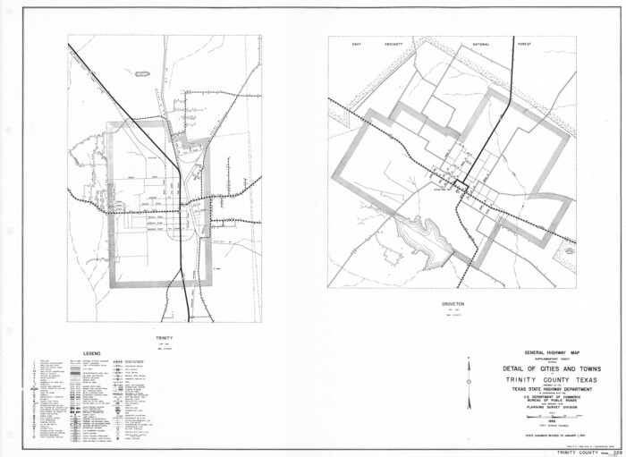
General Highway Map. Detail of Cities and Towns in Trinity County, Texas [Groveton and Trinity and vicinities]
Print $20.00
General Highway Map. Detail of Cities and Towns in Trinity County, Texas [Groveton and Trinity and vicinities]
1961
Size: 18.1 x 24.8 inches
79689
Trinity County Sketch File 39

Print $20.00
- Digital $50.00
Trinity County Sketch File 39
1959
Size: 26.8 x 23.4 inches
12493
Polk County Working Sketch 26

Print $20.00
- Digital $50.00
Polk County Working Sketch 26
1958
Size: 19.0 x 24.8 inches
71642
Polk County Working Sketch 22

Print $40.00
- Digital $50.00
Polk County Working Sketch 22
1957
Size: 43.0 x 64.6 inches
71637
Trinity County Working Sketch 14

Print $20.00
- Digital $50.00
Trinity County Working Sketch 14
1956
Size: 24.8 x 29.9 inches
69463
Trinity County Working Sketch 13

Print $20.00
- Digital $50.00
Trinity County Working Sketch 13
1956
Size: 18.2 x 24.7 inches
69462
Trinity County Working Sketch 12

Print $20.00
- Digital $50.00
Trinity County Working Sketch 12
1950
Size: 46.6 x 36.9 inches
69461
Trinity County Working Sketch 11

Print $20.00
- Digital $50.00
Trinity County Working Sketch 11
1949
Size: 47.0 x 42.6 inches
69460
Trinity County Sketch File 38

Print $8.00
- Digital $50.00
Trinity County Sketch File 38
1948
Size: 14.5 x 8.9 inches
38593
Trinity County Rolled Sketch 2

Print $20.00
- Digital $50.00
Trinity County Rolled Sketch 2
1948
Size: 34.5 x 34.9 inches
10024
Trinity County Rolled Sketch 4

Print $20.00
- Digital $50.00
Trinity County Rolled Sketch 4
1948
Size: 38.5 x 42.4 inches
10026
Trinity County Rolled Sketch 3

Print $40.00
- Digital $50.00
Trinity County Rolled Sketch 3
1948
Size: 33.8 x 50.3 inches
10025
Trinity County Working Sketch 24
Print $20.00
- Digital $50.00
Trinity County Working Sketch 24
2010
-
Size
18.2 x 36.5 inches
-
Map/Doc
89599
-
Creation Date
2010
Trinity County Working Sketch 26
Print $20.00
- Digital $50.00
Trinity County Working Sketch 26
2010
-
Size
21.0 x 34.1 inches
-
Map/Doc
89601
-
Creation Date
2010
Trinity County Working Sketch 25
Print $20.00
- Digital $50.00
Trinity County Working Sketch 25
2010
-
Size
39.7 x 28.7 inches
-
Map/Doc
89600
-
Creation Date
2010
Trinity County Working Sketch 27
Print $20.00
- Digital $50.00
Trinity County Working Sketch 27
2010
-
Size
26.8 x 36.8 inches
-
Map/Doc
90069
-
Creation Date
2010
Trinity County Working Sketch 23
Print $20.00
- Digital $50.00
Trinity County Working Sketch 23
2010
-
Size
23.4 x 33.6 inches
-
Map/Doc
89259
-
Creation Date
2010
Trinity County Working Sketch 22
Print $40.00
- Digital $50.00
Trinity County Working Sketch 22
2009
-
Size
32.0 x 52.1 inches
-
Map/Doc
89068
-
Creation Date
2009
Trinity County Rolled Sketch 7
Print $20.00
- Digital $50.00
Trinity County Rolled Sketch 7
1999
-
Size
24.8 x 36.3 inches
-
Map/Doc
8054
-
Creation Date
1999
Trinity County Rolled Sketch 6
Print $20.00
- Digital $50.00
Trinity County Rolled Sketch 6
1999
-
Size
25.0 x 19.3 inches
-
Map/Doc
8053
-
Creation Date
1999
Trinity County Rolled Sketch 5
Print $20.00
- Digital $50.00
Trinity County Rolled Sketch 5
1993
-
Size
25.3 x 38.0 inches
-
Map/Doc
8052
-
Creation Date
1993
Trinity County Sketch File 44
Print $8.00
- Digital $50.00
Trinity County Sketch File 44
1993
-
Size
11.3 x 9.0 inches
-
Map/Doc
38599
-
Creation Date
1993
Trinity County Working Sketch 21
Print $20.00
- Digital $50.00
Trinity County Working Sketch 21
1992
-
Size
23.1 x 23.1 inches
-
Map/Doc
69470
-
Creation Date
1992
Polk County Working Sketch 42
Print $20.00
- Digital $50.00
Polk County Working Sketch 42
1992
-
Size
30.8 x 35.7 inches
-
Map/Doc
71659
-
Creation Date
1992
Trinity County Working Sketch 18
Print $20.00
- Digital $50.00
Trinity County Working Sketch 18
1982
-
Size
13.4 x 11.1 inches
-
Map/Doc
69467
-
Creation Date
1982
Trinity County Working Sketch 19
Print $20.00
- Digital $50.00
Trinity County Working Sketch 19
1982
-
Size
14.7 x 11.1 inches
-
Map/Doc
69468
-
Creation Date
1982
Trinity County Working Sketch 17
Print $20.00
- Digital $50.00
Trinity County Working Sketch 17
1978
-
Size
24.0 x 26.6 inches
-
Map/Doc
69466
-
Creation Date
1978
Trinity County Working Sketch 16
Print $20.00
- Digital $50.00
Trinity County Working Sketch 16
1978
-
Size
31.7 x 41.2 inches
-
Map/Doc
69465
-
Creation Date
1978
Trinity County Working Sketch 15
Print $20.00
- Digital $50.00
Trinity County Working Sketch 15
1974
-
Size
30.5 x 32.5 inches
-
Map/Doc
69464
-
Creation Date
1974
General Highway Map, Trinity County, Texas
Print $20.00
General Highway Map, Trinity County, Texas
1961
-
Size
18.1 x 24.5 inches
-
Map/Doc
79688
-
Creation Date
1961
General Highway Map. Detail of Cities and Towns in Trinity County, Texas [Groveton and Trinity and vicinities]
Print $20.00
General Highway Map. Detail of Cities and Towns in Trinity County, Texas [Groveton and Trinity and vicinities]
1961
-
Size
18.1 x 24.8 inches
-
Map/Doc
79689
-
Creation Date
1961
Trinity County Sketch File 39
Print $20.00
- Digital $50.00
Trinity County Sketch File 39
1959
-
Size
26.8 x 23.4 inches
-
Map/Doc
12493
-
Creation Date
1959
Polk County Working Sketch 26
Print $20.00
- Digital $50.00
Polk County Working Sketch 26
1958
-
Size
19.0 x 24.8 inches
-
Map/Doc
71642
-
Creation Date
1958
Polk County Working Sketch 22
Print $40.00
- Digital $50.00
Polk County Working Sketch 22
1957
-
Size
43.0 x 64.6 inches
-
Map/Doc
71637
-
Creation Date
1957
Trinity County Working Sketch 14
Print $20.00
- Digital $50.00
Trinity County Working Sketch 14
1956
-
Size
24.8 x 29.9 inches
-
Map/Doc
69463
-
Creation Date
1956
Trinity County Working Sketch 13
Print $20.00
- Digital $50.00
Trinity County Working Sketch 13
1956
-
Size
18.2 x 24.7 inches
-
Map/Doc
69462
-
Creation Date
1956
Trinity County Working Sketch 12
Print $20.00
- Digital $50.00
Trinity County Working Sketch 12
1950
-
Size
46.6 x 36.9 inches
-
Map/Doc
69461
-
Creation Date
1950
Trinity County Working Sketch 11
Print $20.00
- Digital $50.00
Trinity County Working Sketch 11
1949
-
Size
47.0 x 42.6 inches
-
Map/Doc
69460
-
Creation Date
1949
Trinity County Sketch File 38
Print $8.00
- Digital $50.00
Trinity County Sketch File 38
1948
-
Size
14.5 x 8.9 inches
-
Map/Doc
38593
-
Creation Date
1948
Trinity County Rolled Sketch 2
Print $20.00
- Digital $50.00
Trinity County Rolled Sketch 2
1948
-
Size
34.5 x 34.9 inches
-
Map/Doc
10024
-
Creation Date
1948
Trinity County Rolled Sketch 4
Print $20.00
- Digital $50.00
Trinity County Rolled Sketch 4
1948
-
Size
38.5 x 42.4 inches
-
Map/Doc
10026
-
Creation Date
1948
Trinity County Rolled Sketch 3
Print $40.00
- Digital $50.00
Trinity County Rolled Sketch 3
1948
-
Size
33.8 x 50.3 inches
-
Map/Doc
10025
-
Creation Date
1948