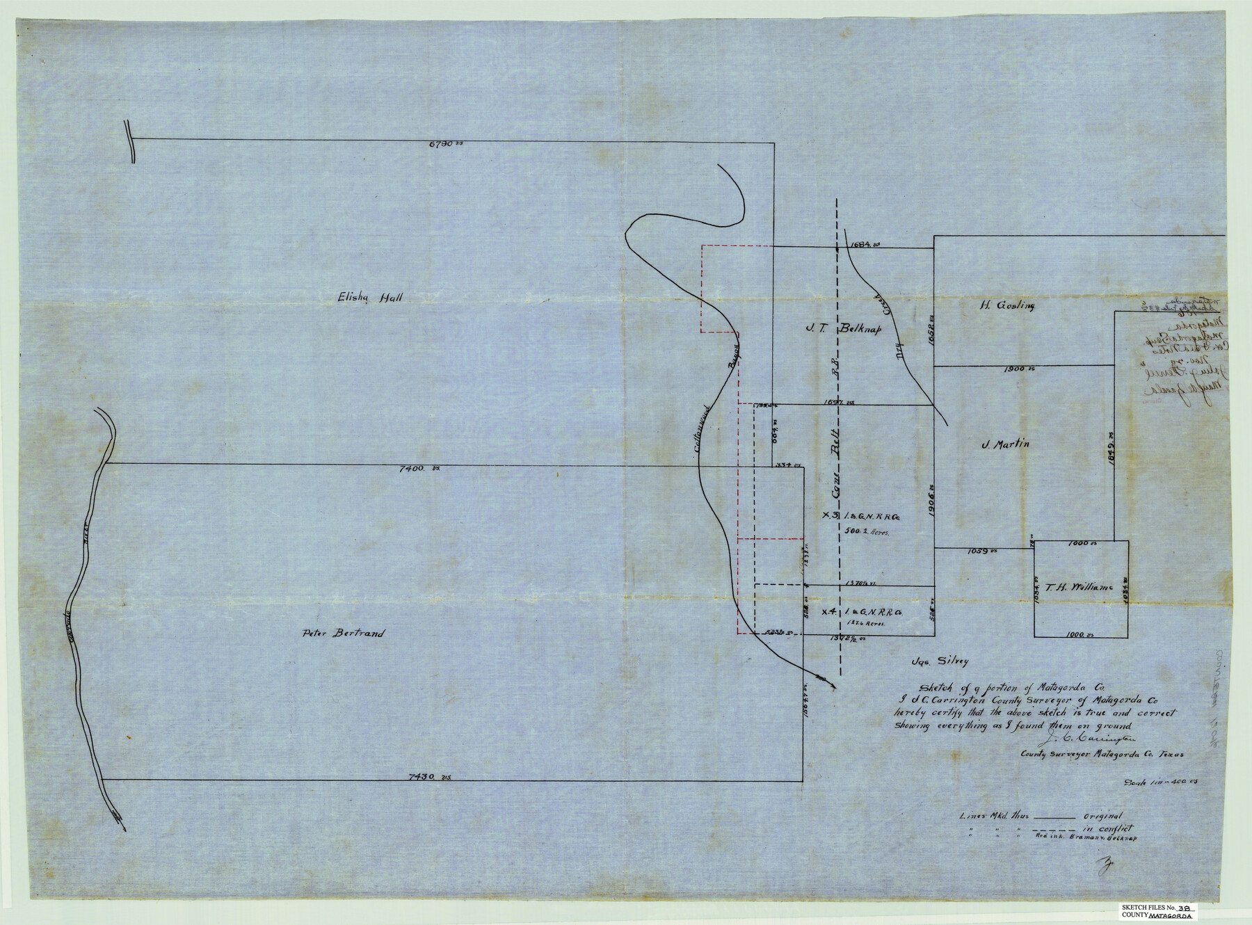
Matagorda County Sketch File 38
[Sketch Showing Surveys in Matagorda County, Texas]
-
Map/Doc
12046
-
Collection
General Map Collection
-
Object Dates
11/29/1904 (Creation Date)
3/7/1978 (File Date)
-
People and Organizations
J.C. Carrington (Surveyor/Engineer)
-
Counties
Matagorda
-
Subjects
Surveying Sketch File
-
Height x Width
24.4 x 33.0 inches
62.0 x 83.8 cm
-
Medium
paper, manuscript
-
Features
Dry Creek
Cottonwood Bayou
Colorado River
Part of: General Map Collection
Liberty County Working Sketch 79

Print $40.00
- Digital $50.00
Liberty County Working Sketch 79
1981
Size 63.7 x 41.4 inches
Map/Doc 70539
Flight Mission No. BRA-8M, Frame 70, Jefferson County

Print $20.00
- Digital $50.00
Flight Mission No. BRA-8M, Frame 70, Jefferson County
1953
Size 18.6 x 22.3 inches
Map/Doc 85590
Map representing the surveys made in Bexar County

Print $40.00
- Digital $50.00
Map representing the surveys made in Bexar County
1839
Size 75.7 x 35.1 inches
Map/Doc 93365
Austin County Working Sketch 3

Print $20.00
- Digital $50.00
Austin County Working Sketch 3
1950
Size 33.3 x 40.1 inches
Map/Doc 67244
Live Oak County Working Sketch 12

Print $20.00
- Digital $50.00
Live Oak County Working Sketch 12
1949
Size 23.1 x 19.7 inches
Map/Doc 70597
Colorado River, Lissie Sheet

Print $20.00
- Digital $50.00
Colorado River, Lissie Sheet
1941
Size 24.2 x 43.0 inches
Map/Doc 65306
Flight Mission No. BRA-16M, Frame 77, Jefferson County

Print $20.00
- Digital $50.00
Flight Mission No. BRA-16M, Frame 77, Jefferson County
1953
Size 18.6 x 22.3 inches
Map/Doc 85694
Milam County Boundary File 2

Print $30.00
- Digital $50.00
Milam County Boundary File 2
Size 12.7 x 8.2 inches
Map/Doc 57202
Jefferson County Working Sketch 18

Print $20.00
- Digital $50.00
Jefferson County Working Sketch 18
1954
Size 24.2 x 30.7 inches
Map/Doc 66561
Hunt County Sketch File 20

Print $4.00
- Digital $50.00
Hunt County Sketch File 20
1853
Size 8.3 x 7.9 inches
Map/Doc 27120
Tarrant County Boundary File 82

Print $22.00
- Digital $50.00
Tarrant County Boundary File 82
Size 8.9 x 7.0 inches
Map/Doc 59173
Coleman County Sketch File 7

Print $2.00
- Digital $50.00
Coleman County Sketch File 7
Size 8.2 x 10.3 inches
Map/Doc 18674
You may also like
[John B. Robinson and surrounding surveys]
![91040, [John B. Robinson and surrounding surveys], Twichell Survey Records](https://historictexasmaps.com/wmedia_w700/maps/91040-1.tif.jpg)
Print $20.00
- Digital $50.00
[John B. Robinson and surrounding surveys]
Size 12.9 x 15.2 inches
Map/Doc 91040
[Sketch for Mineral Application 26501 - Sabine River, T. A. Oldhausen]
![2837, [Sketch for Mineral Application 26501 - Sabine River, T. A. Oldhausen], General Map Collection](https://historictexasmaps.com/wmedia_w700/maps/2837.tif.jpg)
Print $20.00
- Digital $50.00
[Sketch for Mineral Application 26501 - Sabine River, T. A. Oldhausen]
1931
Size 24.1 x 36.0 inches
Map/Doc 2837
1988 Land Use - El Paso, Ciudad Juarez and Vicinity

Print $20.00
- Digital $50.00
1988 Land Use - El Paso, Ciudad Juarez and Vicinity
1988
Size 34.1 x 25.0 inches
Map/Doc 87370
McLennan County Sketch File 9

Print $4.00
- Digital $50.00
McLennan County Sketch File 9
1849
Size 12.5 x 8.1 inches
Map/Doc 31258
[Block M24, Surveys 1-8 and vicinity]
![91231, [Block M24, Surveys 1-8 and vicinity], Twichell Survey Records](https://historictexasmaps.com/wmedia_w700/maps/91231-1.tif.jpg)
Print $20.00
- Digital $50.00
[Block M24, Surveys 1-8 and vicinity]
1909
Size 16.4 x 18.2 inches
Map/Doc 91231
Kerr County Rolled Sketch 4

Print $20.00
- Digital $50.00
Kerr County Rolled Sketch 4
Size 21.8 x 23.1 inches
Map/Doc 6493
Cottle County Working Sketch 4

Print $20.00
- Digital $50.00
Cottle County Working Sketch 4
1916
Size 34.3 x 31.4 inches
Map/Doc 68314
Atascosa County Rolled Sketch 14

Print $20.00
- Digital $50.00
Atascosa County Rolled Sketch 14
1944
Size 37.1 x 46.0 inches
Map/Doc 8430
Jeff Davis County Rolled Sketch 8

Print $20.00
- Digital $50.00
Jeff Davis County Rolled Sketch 8
Size 40.0 x 41.6 inches
Map/Doc 9264
Polk County Working Sketch 38

Print $20.00
- Digital $50.00
Polk County Working Sketch 38
1975
Size 25.4 x 23.5 inches
Map/Doc 71655
Lubbock County Boundary File 11

Print $68.00
- Digital $50.00
Lubbock County Boundary File 11
Size 14.7 x 9.2 inches
Map/Doc 56583
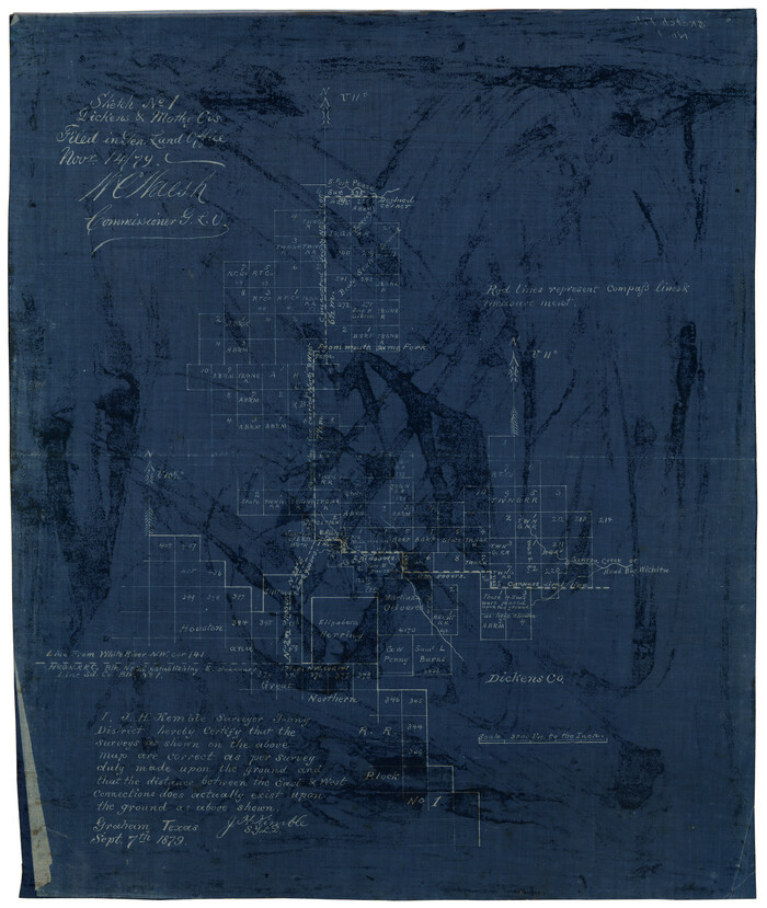
Sketch No. 1, Dickens & Motley Cos.
Print $20.00
- Digital $50.00
Sketch No. 1, Dickens & Motley Cos.
1879
Size 17.9 x 15.5 inches
Map/Doc 10761