Nueces County Sketch File 59
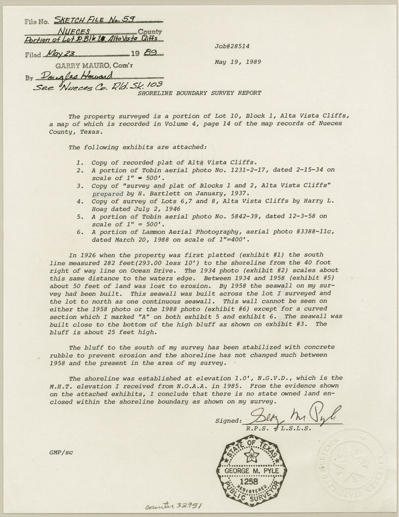
[Survey report, correspondence, aerial photographs, and sketches relating to Lot 10, Block 1, Alta Vista Cliffs]
-
Map/Doc
32951
-
Collection
General Map Collection
-
Object Dates
5/23/1989 (File Date)
5/19/1989 (Creation Date)
-
People and Organizations
George M. Pyle (Surveyor/Engineer)
H. Bartlett (Surveyor/Engineer)
Roy D. Clift (Surveyor/Engineer)
Harry L. Hoag (Surveyor/Engineer)
-
Counties
Nueces
-
Subjects
Surveying Sketch File
-
Height x Width
11.2 x 8.6 inches
28.4 x 21.8 cm
-
Medium
multi-page, multi-format
-
Comments
See Nueces County Rolled Sketch 109 (7116) for sketch.
-
Features
Alta Vista Cliffs
Ocean Drive
Corpus Christi Bay
Denver Avenue
Alta Vista
Warners Street
Rossiter Street
Hopes Street
Proctor Street
Scott Street
Port Aransas Cliffs Addition
Related maps
Nueces County Rolled Sketch 109

Print $20.00
- Digital $50.00
Nueces County Rolled Sketch 109
1989
Size 18.8 x 25.0 inches
Map/Doc 7116
Part of: General Map Collection
Hamilton County Working Sketch 18

Print $20.00
- Digital $50.00
Hamilton County Working Sketch 18
1952
Size 22.4 x 25.1 inches
Map/Doc 63356
Flight Mission No. BRA-7M, Frame 30, Jefferson County

Print $20.00
- Digital $50.00
Flight Mission No. BRA-7M, Frame 30, Jefferson County
1953
Size 18.6 x 22.3 inches
Map/Doc 85481
Coryell County Working Sketch 16

Print $20.00
- Digital $50.00
Coryell County Working Sketch 16
1957
Size 22.0 x 21.4 inches
Map/Doc 68223
Morris County Rolled Sketch 2A

Print $20.00
- Digital $50.00
Morris County Rolled Sketch 2A
Size 24.0 x 18.8 inches
Map/Doc 10238
Knox County Rolled Sketch 14

Print $40.00
- Digital $50.00
Knox County Rolled Sketch 14
1892
Size 21.8 x 54.9 inches
Map/Doc 10666
Kimble County Rolled Sketch 33

Print $20.00
- Digital $50.00
Kimble County Rolled Sketch 33
1973
Size 26.7 x 20.1 inches
Map/Doc 6523
Matagorda County Rolled Sketch H & W

Matagorda County Rolled Sketch H & W
1936
Size 27.1 x 41.2 inches
Map/Doc 61776
Hale County Sketch File D

Print $40.00
- Digital $50.00
Hale County Sketch File D
1901
Size 16.5 x 12.2 inches
Map/Doc 24721
Edwards County

Print $20.00
- Digital $50.00
Edwards County
1893
Size 25.8 x 29.4 inches
Map/Doc 3506
Wharton County

Print $40.00
- Digital $50.00
Wharton County
1894
Size 52.3 x 56.3 inches
Map/Doc 16923
Hopkins County Sketch File 27

Print $6.00
- Digital $50.00
Hopkins County Sketch File 27
1873
Size 16.6 x 11.0 inches
Map/Doc 26738
Anderson County Working Sketch 29

Print $20.00
- Digital $50.00
Anderson County Working Sketch 29
1962
Size 24.6 x 27.2 inches
Map/Doc 67029
You may also like
Milam County Rolled Sketch 2

Print $20.00
- Digital $50.00
Milam County Rolled Sketch 2
1954
Size 21.9 x 24.8 inches
Map/Doc 6774
Haskell County Sketch File 23

Print $40.00
- Digital $50.00
Haskell County Sketch File 23
1939
Size 23.2 x 13.5 inches
Map/Doc 11745
FT. W. & R. G. Ry. Right of Way Map, Winchell to Brady, McCulloch County, Texas

Print $40.00
- Digital $50.00
FT. W. & R. G. Ry. Right of Way Map, Winchell to Brady, McCulloch County, Texas
1918
Size 38.0 x 121.9 inches
Map/Doc 61410
Right of Way & Track Map, San Antonio & Aransas Pass Railway Co.

Print $40.00
- Digital $50.00
Right of Way & Track Map, San Antonio & Aransas Pass Railway Co.
1919
Size 25.3 x 56.5 inches
Map/Doc 64213
Grayson County Boundary File 2

Print $14.00
- Digital $50.00
Grayson County Boundary File 2
Size 12.7 x 7.9 inches
Map/Doc 53931
Garza County Sketch File 8

Print $8.00
- Digital $50.00
Garza County Sketch File 8
1900
Size 10.3 x 8.2 inches
Map/Doc 24062
Gulf Coast of the United States, Key West to Rio Grande

Print $40.00
Gulf Coast of the United States, Key West to Rio Grande
1863
Size 30.2 x 53.5 inches
Map/Doc 79335
Natural Heritage of Texas

Print $40.00
- Digital $50.00
Natural Heritage of Texas
1986
Size 54.3 x 56.0 inches
Map/Doc 10786
Limestone County Sketch File 16

Print $4.00
- Digital $50.00
Limestone County Sketch File 16
Size 12.8 x 8.3 inches
Map/Doc 30185

Map of Jefferson County

Print $20.00
- Digital $50.00
Map of Jefferson County
1896
Size 25.3 x 21.6 inches
Map/Doc 3731
Kenedy County Boundary File 1

Print $10.00
- Digital $50.00
Kenedy County Boundary File 1
Size 9.1 x 5.5 inches
Map/Doc 55777