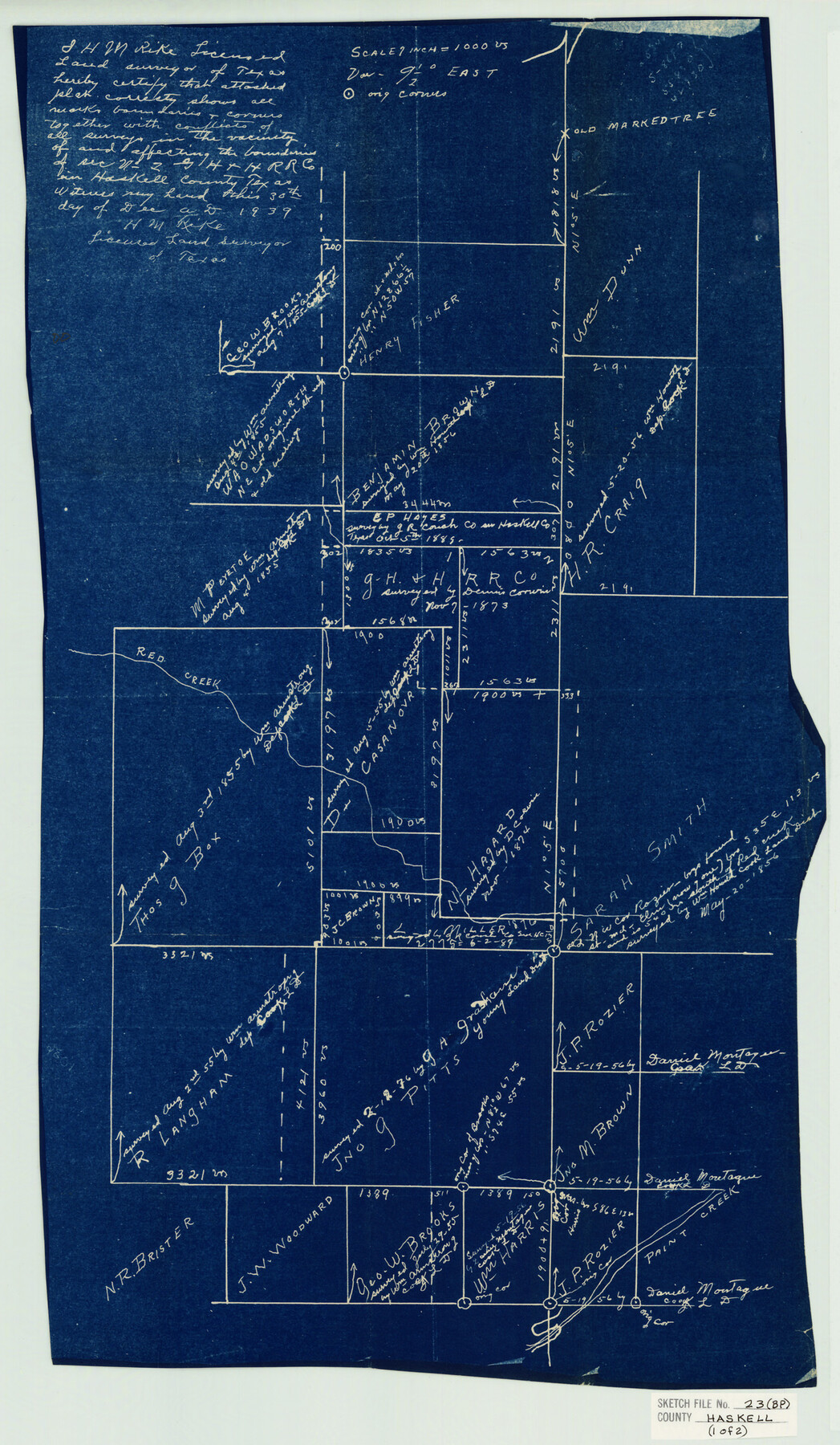
Haskell County Sketch File 23
Surs. Sk. G.H.&H. RR. Co.
-
Map/Doc
11745
-
Collection
General Map Collection
-
Object Dates
1939/12/30 (Creation Date)
1940/1/3 (File Date)
-
People and Organizations
H.M. Rike (Surveyor/Engineer)
-
Counties
Haskell
-
Subjects
Surveying Sketch File
-
Height x Width
23.2 x 13.5 inches
58.9 x 34.3 cm
-
Medium
blueprint/diazo
-
Scale
1" = 1000 varas
-
Features
Red Creek
Paint Creek
Part of: General Map Collection
Hudspeth County Rolled Sketch 69

Print $20.00
- Digital $50.00
Hudspeth County Rolled Sketch 69
1973
Size 12.3 x 19.2 inches
Map/Doc 7718
Zapata County Working Sketch 24

Print $20.00
- Digital $50.00
Zapata County Working Sketch 24
1992
Size 28.2 x 23.9 inches
Map/Doc 62075
Current Miscellaneous File 66

Print $34.00
- Digital $50.00
Current Miscellaneous File 66
Size 11.2 x 8.6 inches
Map/Doc 74113
[Map of Coahuila and Nuevo Leon]
![97128, [Map of Coahuila and Nuevo Leon], General Map Collection](https://historictexasmaps.com/wmedia_w700/maps/97128.tif.jpg)
Print $20.00
- Digital $50.00
[Map of Coahuila and Nuevo Leon]
1873
Size 16.8 x 11.6 inches
Map/Doc 97128
Baylor County

Print $20.00
- Digital $50.00
Baylor County
1917
Size 47.3 x 40.7 inches
Map/Doc 66712
Harrison County Working Sketch 3

Print $20.00
- Digital $50.00
Harrison County Working Sketch 3
1942
Size 43.8 x 19.0 inches
Map/Doc 66023
Hansford County Sketch File 8

Print $6.00
- Digital $50.00
Hansford County Sketch File 8
1927
Size 11.3 x 8.7 inches
Map/Doc 24960
San Luis Pass to East Matagorda Bay

Print $20.00
- Digital $50.00
San Luis Pass to East Matagorda Bay
1973
Size 35.0 x 46.8 inches
Map/Doc 69968
Hays County Rolled Sketch 29

Print $20.00
- Digital $50.00
Hays County Rolled Sketch 29
1954
Size 26.1 x 28.0 inches
Map/Doc 6184
Flight Mission No. DQN-2K, Frame 31, Calhoun County

Print $20.00
- Digital $50.00
Flight Mission No. DQN-2K, Frame 31, Calhoun County
1953
Size 18.7 x 22.3 inches
Map/Doc 84238
Borden County Sketch File 6

Print $8.00
- Digital $50.00
Borden County Sketch File 6
1900
Size 11.2 x 8.7 inches
Map/Doc 14719
Tarrant County Boundary File 1

Print $20.00
- Digital $50.00
Tarrant County Boundary File 1
Size 9.2 x 34.6 inches
Map/Doc 59110
You may also like
Montgomery County Working Sketch 76

Print $20.00
- Digital $50.00
Montgomery County Working Sketch 76
Size 16.5 x 18.3 inches
Map/Doc 78191
Sketch of a part of Galveston Island

Print $3.00
- Digital $50.00
Sketch of a part of Galveston Island
Size 10.8 x 13.8 inches
Map/Doc 430
Hale County Sketch File D

Print $40.00
- Digital $50.00
Hale County Sketch File D
1901
Size 16.5 x 12.2 inches
Map/Doc 24721
Menard County Working Sketch 30

Print $20.00
- Digital $50.00
Menard County Working Sketch 30
1974
Size 47.9 x 38.8 inches
Map/Doc 70977
Clay County Sketch File 28

Print $20.00
- Digital $50.00
Clay County Sketch File 28
Size 25.3 x 31.2 inches
Map/Doc 11090
[Blocks RG, I and S]
![92726, [Blocks RG, I and S], Twichell Survey Records](https://historictexasmaps.com/wmedia_w700/maps/92726-1.tif.jpg)
Print $20.00
- Digital $50.00
[Blocks RG, I and S]
Size 36.7 x 37.2 inches
Map/Doc 92726
Nacogdoches County Sketch File 21

Print $20.00
- Digital $50.00
Nacogdoches County Sketch File 21
1837
Size 9.4 x 5.5 inches
Map/Doc 32286
Reagan County Sketch File 2A

Print $6.00
- Digital $50.00
Reagan County Sketch File 2A
1882
Size 9.1 x 17.6 inches
Map/Doc 12211
Bexar County Sketch File 58

Print $4.00
- Digital $50.00
Bexar County Sketch File 58
1847
Size 10.4 x 8.3 inches
Map/Doc 14572
La Salle County Rolled Sketch 13

Print $20.00
- Digital $50.00
La Salle County Rolled Sketch 13
1948
Size 28.7 x 34.2 inches
Map/Doc 6576
Willacy County

Print $20.00
- Digital $50.00
Willacy County
1921
Size 25.2 x 32.2 inches
Map/Doc 73325
