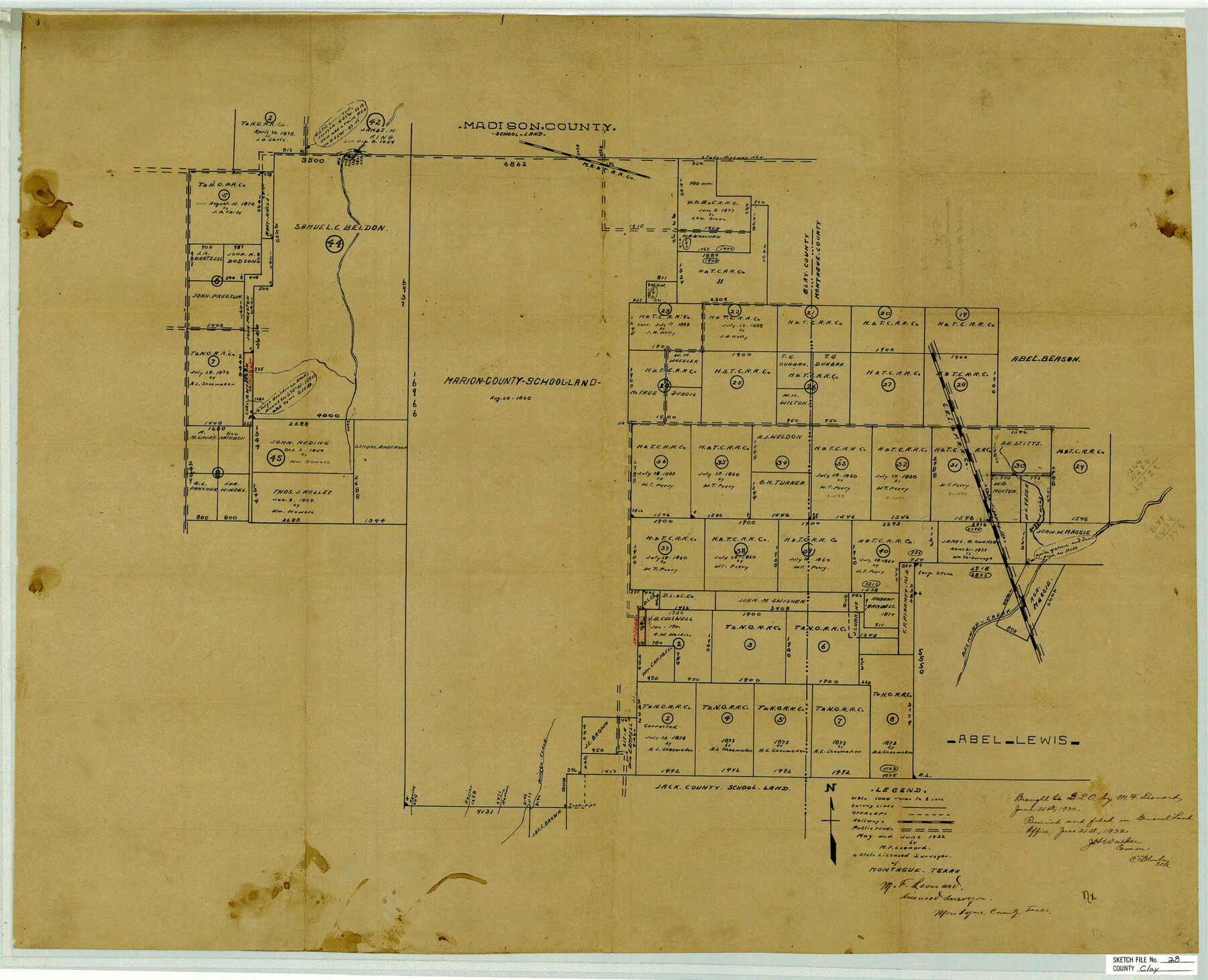
Clay County Sketch File 28
[Sketch of Montague County School Land survey and surrounding area in eastern part of Clay County and western Montague County]
-
Map/Doc
11090
-
Collection
General Map Collection
-
Object Dates
1932 (Survey Date)
1932/6/21 (File Date)
1932 (Survey Date)
-
People and Organizations
M.F. Leonard (Surveyor/Engineer)
-
Counties
Clay Montague
-
Subjects
Surveying Sketch File
-
Height x Width
25.3 x 31.2 inches
64.3 x 79.2 cm
-
Medium
paper, manuscript
-
Scale
1" = 1000 varas
-
Features
MK&T
State Highway 5
CRI&P
Wilson Creek
Belknap Creek
Part of: General Map Collection
Trinity County Sketch File 12

Print $4.00
- Digital $50.00
Trinity County Sketch File 12
1857
Size 12.8 x 8.0 inches
Map/Doc 38535
[Galveston, Harrisburg & San Antonio through El Paso County]
![64004, [Galveston, Harrisburg & San Antonio through El Paso County], General Map Collection](https://historictexasmaps.com/wmedia_w700/maps/64004.tif.jpg)
Print $20.00
- Digital $50.00
[Galveston, Harrisburg & San Antonio through El Paso County]
Size 13.6 x 33.6 inches
Map/Doc 64004
Flight Mission No. BRA-16M, Frame 70, Jefferson County

Print $20.00
- Digital $50.00
Flight Mission No. BRA-16M, Frame 70, Jefferson County
1953
Size 18.6 x 22.3 inches
Map/Doc 85687
San Saba County Sketch File 15

Print $6.00
- Digital $50.00
San Saba County Sketch File 15
Size 14.2 x 8.9 inches
Map/Doc 36453
Dawson County Working Sketch 6

Print $20.00
- Digital $50.00
Dawson County Working Sketch 6
1939
Size 43.9 x 42.7 inches
Map/Doc 68550
Current Miscellaneous File 76

Print $10.00
- Digital $50.00
Current Miscellaneous File 76
1960
Size 11.3 x 8.8 inches
Map/Doc 74189
Fannin County Boundary File 3

Print $36.00
- Digital $50.00
Fannin County Boundary File 3
Size 13.2 x 8.8 inches
Map/Doc 53295
Liberty County Rolled Sketch N

Print $20.00
- Digital $50.00
Liberty County Rolled Sketch N
1954
Size 45.1 x 39.1 inches
Map/Doc 10721
Flight Mission No. BRA-16M, Frame 53, Jefferson County

Print $20.00
- Digital $50.00
Flight Mission No. BRA-16M, Frame 53, Jefferson County
1953
Size 18.4 x 22.6 inches
Map/Doc 85670
Briscoe County Sketch File A

Print $40.00
- Digital $50.00
Briscoe County Sketch File A
1894
Size 17.3 x 21.1 inches
Map/Doc 10997
Flight Mission No. DIX-7P, Frame 16, Aransas County

Print $20.00
- Digital $50.00
Flight Mission No. DIX-7P, Frame 16, Aransas County
1956
Size 18.9 x 22.5 inches
Map/Doc 83868
Mason County Rolled Sketch 1

Print $20.00
- Digital $50.00
Mason County Rolled Sketch 1
1939
Size 38.3 x 27.2 inches
Map/Doc 6673
You may also like
[Surveys in Austin's Colony along the Navidad River, Caney Fork, and upper Rocky Creek]
![201, [Surveys in Austin's Colony along the Navidad River, Caney Fork, and upper Rocky Creek], General Map Collection](https://historictexasmaps.com/wmedia_w700/maps/201-1.tif.jpg)
Print $20.00
- Digital $50.00
[Surveys in Austin's Colony along the Navidad River, Caney Fork, and upper Rocky Creek]
1831
Size 20.5 x 26.7 inches
Map/Doc 201
Grayson County Sketch File 6

Print $8.00
- Digital $50.00
Grayson County Sketch File 6
Size 12.9 x 8.2 inches
Map/Doc 24466
From Citizens of Colorado and Matagorda Counties for the Creation of a New County (Unnamed), August 6, 1840

Print $20.00
From Citizens of Colorado and Matagorda Counties for the Creation of a New County (Unnamed), August 6, 1840
2020
Size 18.5 x 21.7 inches
Map/Doc 96389
Stonewall County Sketch File 13

Print $20.00
- Digital $50.00
Stonewall County Sketch File 13
1901
Size 22.4 x 18.8 inches
Map/Doc 12365
Newton County Working Sketch 44

Print $20.00
- Digital $50.00
Newton County Working Sketch 44
1992
Size 19.2 x 24.6 inches
Map/Doc 71290
Concho County Rolled Sketch 23

Print $20.00
- Digital $50.00
Concho County Rolled Sketch 23
1971
Size 22.8 x 22.4 inches
Map/Doc 78463
Map of South Boundary Line of Hartley County

Print $20.00
- Digital $50.00
Map of South Boundary Line of Hartley County
Size 26.3 x 8.2 inches
Map/Doc 90685
Bailey County Sketch File 15

Print $18.00
- Digital $50.00
Bailey County Sketch File 15
1912
Size 8.7 x 11.2 inches
Map/Doc 13975
[T. & P. RR. Lands and Surrounding surveys]
![91131, [T. & P. RR. Lands and Surrounding surveys], Twichell Survey Records](https://historictexasmaps.com/wmedia_w700/maps/91131.tif.jpg)
Print $20.00
- Digital $50.00
[T. & P. RR. Lands and Surrounding surveys]
1900
Size 16.4 x 12.2 inches
Map/Doc 91131
Cherokee County Working Sketch 28

Print $20.00
- Digital $50.00
Cherokee County Working Sketch 28
1991
Size 13.7 x 16.8 inches
Map/Doc 67983
La Salle County Sketch File 40

Print $6.00
- Digital $50.00
La Salle County Sketch File 40
1918
Size 11.2 x 8.7 inches
Map/Doc 29594
Freestone County Sketch File 16

Print $4.00
- Digital $50.00
Freestone County Sketch File 16
Size 6.4 x 8.7 inches
Map/Doc 23072