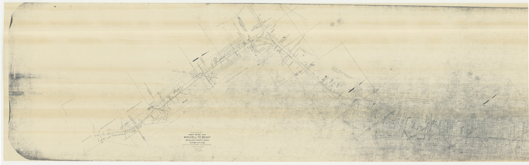
FT. W. & R. G. Ry. Right of Way Map, Winchell to Brady, McCulloch County, Texas
M.P. 158 to M.P. 186
Z-2-220, N.1.46
-
Map/Doc
61410
-
Collection
General Map Collection
-
Object Dates
1918 (Creation Date)
-
People and Organizations
Office of Chief Engineer (Publisher)
-
Counties
McCulloch
-
Subjects
Railroads
-
Height x Width
38.0 x 121.9 inches
96.5 x 309.6 cm
-
Medium
paper, photocopy
-
Scale
1 inch = 400 feet
-
Comments
See 61411 and 61414-61416 for related segments.
-
Features
FW&RG
Part of: General Map Collection
[Sketch for Mineral Application 26543 - Sabine River, D. H. Sanford]
![65677, [Sketch for Mineral Application 26543 - Sabine River, D. H. Sanford], General Map Collection](https://historictexasmaps.com/wmedia_w700/maps/65677.tif.jpg)
Print $40.00
- Digital $50.00
[Sketch for Mineral Application 26543 - Sabine River, D. H. Sanford]
1931
Size 30.8 x 71.9 inches
Map/Doc 65677
Donley County Sketch File 22

Print $20.00
- Digital $50.00
Donley County Sketch File 22
Size 20.4 x 28.0 inches
Map/Doc 11368
Polk County Sketch File 39

Print $24.00
- Digital $50.00
Polk County Sketch File 39
Size 8.3 x 13.3 inches
Map/Doc 34278
Bell County Sketch File 12

Print $4.00
- Digital $50.00
Bell County Sketch File 12
1852
Size 8.1 x 12.5 inches
Map/Doc 14385
Hudspeth County Working Sketch 32a

Print $40.00
- Digital $50.00
Hudspeth County Working Sketch 32a
1975
Size 57.4 x 39.3 inches
Map/Doc 66317
Hudspeth County Rolled Sketch 19

Print $20.00
- Digital $50.00
Hudspeth County Rolled Sketch 19
Size 47.8 x 44.6 inches
Map/Doc 9205
Bexar County Working Sketch 9

Print $20.00
- Digital $50.00
Bexar County Working Sketch 9
1956
Size 23.4 x 21.6 inches
Map/Doc 67325
Flight Mission No. DQN-1K, Frame 131, Calhoun County

Print $20.00
- Digital $50.00
Flight Mission No. DQN-1K, Frame 131, Calhoun County
1953
Size 18.6 x 22.4 inches
Map/Doc 84194
Boundary between Republic of Texas and US from Logan's Ferry to Red River - surveyed in 1841

Print $20.00
- Digital $50.00
Boundary between Republic of Texas and US from Logan's Ferry to Red River - surveyed in 1841
1841
Size 19.4 x 27.4 inches
Map/Doc 65415
A Map of Texas published by the Dallas Morning News for the Texas Almanac and State Industrial Guide

A Map of Texas published by the Dallas Morning News for the Texas Almanac and State Industrial Guide
1936
Size 20.3 x 26.1 inches
Map/Doc 94293
Denton County Working Sketch 24

Print $20.00
- Digital $50.00
Denton County Working Sketch 24
1989
Size 22.2 x 30.0 inches
Map/Doc 68629
Uvalde County Working Sketch 52

Print $20.00
- Digital $50.00
Uvalde County Working Sketch 52
1982
Size 45.2 x 35.8 inches
Map/Doc 72122
You may also like
Culberson County Rolled Sketch 11

Print $20.00
- Digital $50.00
Culberson County Rolled Sketch 11
1898
Size 25.6 x 45.9 inches
Map/Doc 5648
Donley County Sketch File 16

Print $4.00
- Digital $50.00
Donley County Sketch File 16
Size 14.6 x 8.8 inches
Map/Doc 21253
La Salle County Sketch File 48

Print $6.00
- Digital $50.00
La Salle County Sketch File 48
1942
Size 11.2 x 8.8 inches
Map/Doc 29617
Atascosa County

Print $20.00
- Digital $50.00
Atascosa County
1948
Size 46.6 x 45.4 inches
Map/Doc 73072
Van Zandt County Working Sketch 9

Print $20.00
- Digital $50.00
Van Zandt County Working Sketch 9
1982
Size 12.6 x 11.7 inches
Map/Doc 72259
Travis County Rolled Sketch 57

Print $20.00
- Digital $50.00
Travis County Rolled Sketch 57
1885
Size 16.5 x 23.3 inches
Map/Doc 8048
[Blocks Surrounding Block T]
![92891, [Blocks Surrounding Block T], Twichell Survey Records](https://historictexasmaps.com/wmedia_w700/maps/92891-1.tif.jpg)
Print $20.00
- Digital $50.00
[Blocks Surrounding Block T]
Size 20.8 x 24.3 inches
Map/Doc 92891
Garza County Sketch File X

Print $22.00
- Digital $50.00
Garza County Sketch File X
Size 17.1 x 12.3 inches
Map/Doc 24042

A New Map of the United States upon which are delineated its vast works of internal communication, routes across the continent &c. showing also Canada and the Island of Cuba

Print $20.00
- Digital $50.00
A New Map of the United States upon which are delineated its vast works of internal communication, routes across the continent &c. showing also Canada and the Island of Cuba
Size 25.8 x 30.6 inches
Map/Doc 93996
[Surveying Sketch of Jesse McGee, Jas McKim, W. S. Kennard, et al in Sabine and Newton Counties, Texas]
![5066, [Surveying Sketch of Jesse McGee, Jas McKim, W. S. Kennard, et al in Sabine and Newton Counties, Texas], Maddox Collection](https://historictexasmaps.com/wmedia_w700/maps/5066.tif.jpg)
Print $20.00
- Digital $50.00
[Surveying Sketch of Jesse McGee, Jas McKim, W. S. Kennard, et al in Sabine and Newton Counties, Texas]
1916
Size 32.0 x 37.5 inches
Map/Doc 5066
Pecos County Working Sketch 51

Print $20.00
- Digital $50.00
Pecos County Working Sketch 51
1948
Size 22.5 x 21.9 inches
Map/Doc 71523