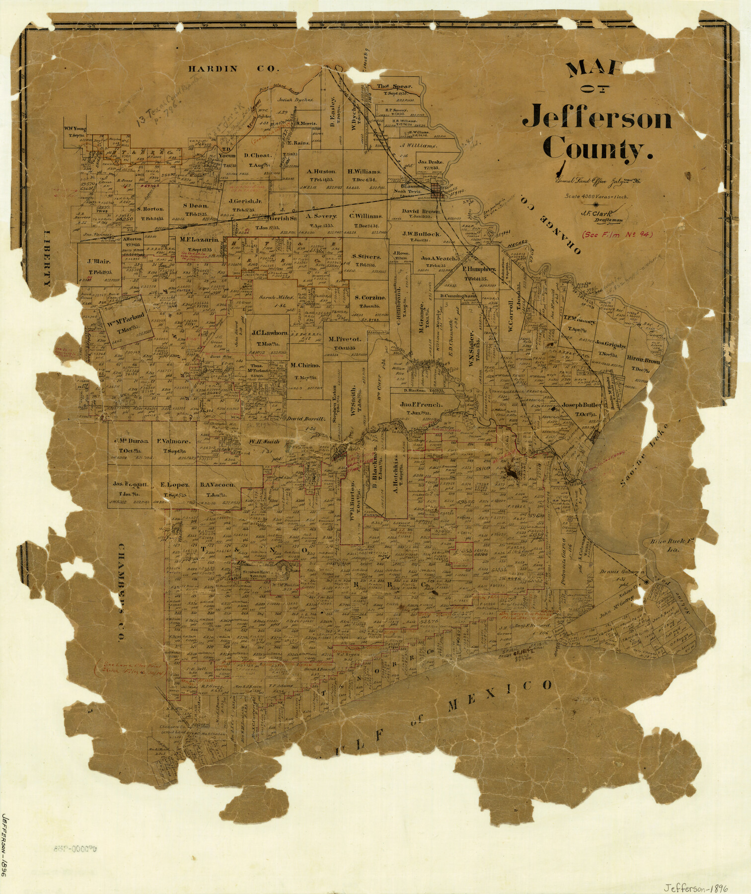
Map of Jefferson County
-
Map/Doc
3731
-
Collection
General Map Collection
-
Object Dates
7/22/1896 (Creation Date)
-
People and Organizations
J.F. Clark (Draftsman)
-
Counties
Jefferson
-
Subjects
County
-
Height x Width
25.3 x 21.6 inches
64.3 x 54.9 cm
-
Features
S&ET
Big Hill
Mayhaw Bayou
Round Lake
Blue Buck Point Lake
Sabine Pass
Blue Buck Point
Blue Buck Lake
Gulf of Mexico
North Fork of Taylors Bayou
GB & KC
SPRR
Sour Lake Station
Alligator Bayou
Mud Bayou
Big Hill
Sabine City
T&NO
Cotton Creek
Pine Island Bayou
S&ET
GB&KC
Neches River
Beaumont
KCP&G
Double Point Bayou
Willow Marsh Bayou
Pine Island Station
China Station
Bayou Din
Hillibrand Bayou
Sabine Lake
Port Arthur
Taylors Bayou
Part of: General Map Collection
Flight Mission No. CRC-2R, Frame 62, Chambers County

Print $20.00
- Digital $50.00
Flight Mission No. CRC-2R, Frame 62, Chambers County
1956
Size 18.6 x 22.5 inches
Map/Doc 84733
Throckmorton County Sketch File 9

Print $7.00
- Digital $50.00
Throckmorton County Sketch File 9
1910
Size 8.4 x 8.4 inches
Map/Doc 38099
Red River County Working Sketch 84

Print $20.00
- Digital $50.00
Red River County Working Sketch 84
1989
Size 24.9 x 40.3 inches
Map/Doc 72070
Zavala County Sketch File 20

Print $4.00
- Digital $50.00
Zavala County Sketch File 20
1911
Size 9.1 x 8.2 inches
Map/Doc 41374
Crane County Working Sketch 11

Print $20.00
- Digital $50.00
Crane County Working Sketch 11
1941
Size 18.8 x 18.4 inches
Map/Doc 68288
Dallam County Sketch File 13

Print $20.00
- Digital $50.00
Dallam County Sketch File 13
Size 22.2 x 20.3 inches
Map/Doc 11280
Val Verde County Rolled Sketch 69

Print $40.00
- Digital $50.00
Val Verde County Rolled Sketch 69
1942
Size 72.5 x 20.0 inches
Map/Doc 9805
Harrison County State Real Property Sketch 1

Print $20.00
- Digital $50.00
Harrison County State Real Property Sketch 1
1986
Size 24.2 x 25.4 inches
Map/Doc 61666
Webb County Sketch File 12d

Print $20.00
- Digital $50.00
Webb County Sketch File 12d
1886
Size 17.0 x 17.9 inches
Map/Doc 12629
Zavala County Working Sketch 30

Print $20.00
- Digital $50.00
Zavala County Working Sketch 30
1989
Size 36.8 x 28.1 inches
Map/Doc 62105
Val Verde County Working Sketch 69

Print $20.00
- Digital $50.00
Val Verde County Working Sketch 69
1965
Size 35.6 x 37.3 inches
Map/Doc 72204
Platts [sic] of S. C. Robertson Surveys
![105, Platts [sic] of S. C. Robertson Surveys, General Map Collection](https://historictexasmaps.com/wmedia_w700/maps/105.tif.jpg)
Print $20.00
- Digital $50.00
Platts [sic] of S. C. Robertson Surveys
1841
Size 13.6 x 15.7 inches
Map/Doc 105
You may also like
Bastrop County Sketch File 10

Print $4.00
- Digital $50.00
Bastrop County Sketch File 10
1979
Size 14.3 x 8.8 inches
Map/Doc 14056
Contracted Boundaries and Timeline of Mexican Empresario Colonies in Texas

Contracted Boundaries and Timeline of Mexican Empresario Colonies in Texas
2025
Size 17.0 x 11.0 inches
Map/Doc 97439
Jefferson County Sketch File 54

Print $226.00
- Digital $50.00
Jefferson County Sketch File 54
1961
Size 11.0 x 8.5 inches
Map/Doc 28359
Edwards County Sketch File 41

Print $20.00
- Digital $50.00
Edwards County Sketch File 41
Size 33.7 x 22.7 inches
Map/Doc 11439
Runnels County Rolled Sketch 36

Print $40.00
- Digital $50.00
Runnels County Rolled Sketch 36
Size 61.2 x 43.0 inches
Map/Doc 76027
Floyd County Sketch File 11

Print $2.00
- Digital $50.00
Floyd County Sketch File 11
1914
Size 3.8 x 6.7 inches
Map/Doc 22707
Fisher County Working Sketch 19

Print $20.00
- Digital $50.00
Fisher County Working Sketch 19
1962
Size 26.2 x 25.5 inches
Map/Doc 69153
Blanco County Working Sketch 22

Print $20.00
- Digital $50.00
Blanco County Working Sketch 22
1962
Size 41.0 x 36.5 inches
Map/Doc 67382
Map of the Houston & Texas Central Railway and connections

Print $20.00
- Digital $50.00
Map of the Houston & Texas Central Railway and connections
1871
Size 16.6 x 15.4 inches
Map/Doc 95753
Lavaca County Rolled Sketch 6

Print $20.00
- Digital $50.00
Lavaca County Rolled Sketch 6
1986
Size 44.8 x 33.9 inches
Map/Doc 10290
Greater Fort Worth City

Print $20.00
- Digital $50.00
Greater Fort Worth City
1919
Size 31.2 x 21.5 inches
Map/Doc 93423
Brazoria County Sketch File 36

Print $40.00
- Digital $50.00
Brazoria County Sketch File 36
1933
Size 34.6 x 45.6 inches
Map/Doc 10325