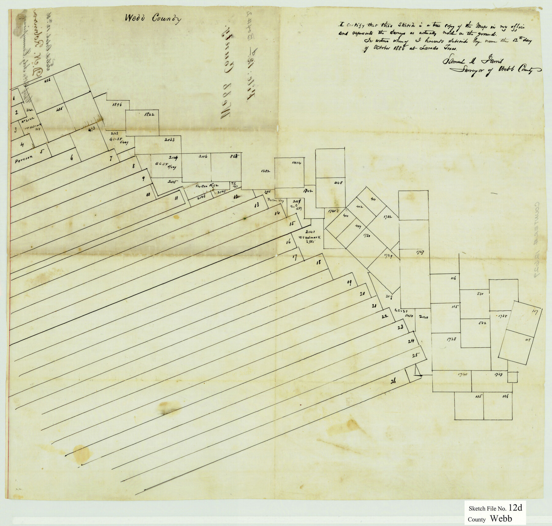
Webb County Sketch File 12d
[Sketch of Porciones and surveys to the east north of Laredo]
-
Map/Doc
12629
-
Collection
General Map Collection
-
Object Dates
10/12/1886 (Creation Date)
-
People and Organizations
Samuel M. Jarvis (Surveyor/Engineer)
-
Counties
Webb
-
Subjects
Surveying Sketch File
-
Height x Width
17.0 x 17.9 inches
43.2 x 45.5 cm
-
Medium
paper, manuscript
Part of: General Map Collection
Nueces County NRC Article 33.136 Sketch 6

Print $44.00
- Digital $50.00
Nueces County NRC Article 33.136 Sketch 6
2002
Size 23.4 x 35.2 inches
Map/Doc 78658
Marion County Working Sketch 24

Print $20.00
- Digital $50.00
Marion County Working Sketch 24
1960
Size 21.4 x 26.4 inches
Map/Doc 70800
Andrews County Boundary File 3

Print $8.00
- Digital $50.00
Andrews County Boundary File 3
Size 7.2 x 8.6 inches
Map/Doc 49717
Brazoria County Sketch File 8

Print $4.00
- Digital $50.00
Brazoria County Sketch File 8
1874
Size 12.4 x 8.4 inches
Map/Doc 14934
Armstrong County Working Sketch 11

Print $20.00
- Digital $50.00
Armstrong County Working Sketch 11
2025
Size 24.7 x 36.5 inches
Map/Doc 97507
Bexar County Working Sketch 2

Print $20.00
- Digital $50.00
Bexar County Working Sketch 2
1940
Size 24.8 x 27.9 inches
Map/Doc 67318
[Surveys near the city of Bastrop]
![107, [Surveys near the city of Bastrop], General Map Collection](https://historictexasmaps.com/wmedia_w700/maps/107.tif.jpg)
Print $2.00
- Digital $50.00
[Surveys near the city of Bastrop]
1841
Size 6.5 x 7.0 inches
Map/Doc 107
Navigation Maps of Gulf Intracoastal Waterway, Port Arthur to Brownsville, Texas

Print $4.00
- Digital $50.00
Navigation Maps of Gulf Intracoastal Waterway, Port Arthur to Brownsville, Texas
1951
Size 16.8 x 21.6 inches
Map/Doc 65419
Wharton County Working Sketch 10

Print $20.00
- Digital $50.00
Wharton County Working Sketch 10
1980
Size 23.6 x 18.7 inches
Map/Doc 72474
Maps of Gulf Intracoastal Waterway, Texas - Sabine River to the Rio Grande and connecting waterways including ship channels

Print $20.00
- Digital $50.00
Maps of Gulf Intracoastal Waterway, Texas - Sabine River to the Rio Grande and connecting waterways including ship channels
1966
Size 14.6 x 22.3 inches
Map/Doc 61950
Gaines County Sketch File 25

Print $4.00
- Digital $50.00
Gaines County Sketch File 25
2002
Size 11.0 x 8.5 inches
Map/Doc 82618
Township No. 4 South Range No. 16 West of the Indian Meridian

Print $20.00
- Digital $50.00
Township No. 4 South Range No. 16 West of the Indian Meridian
1875
Size 19.4 x 24.4 inches
Map/Doc 75165
You may also like
Runnels County Sketch File 17

Print $6.00
Runnels County Sketch File 17
Size 11.0 x 13.6 inches
Map/Doc 35474
[Young Territory]
![16784, [Young Territory], General Map Collection](https://historictexasmaps.com/wmedia_w700/maps/16784.tif.jpg)
Print $40.00
- Digital $50.00
[Young Territory]
1875
Size 49.0 x 87.4 inches
Map/Doc 16784
Dimmit County Working Sketch 19

Print $20.00
- Digital $50.00
Dimmit County Working Sketch 19
1948
Size 27.4 x 23.3 inches
Map/Doc 68680
La Salle County Rolled Sketch 30

Print $20.00
- Digital $50.00
La Salle County Rolled Sketch 30
Size 30.1 x 40.8 inches
Map/Doc 6590
Webb County Sketch File 52

Print $40.00
- Digital $50.00
Webb County Sketch File 52
1939
Size 14.2 x 16.7 inches
Map/Doc 39839
Castro County Rolled Sketch 10

Print $20.00
- Digital $50.00
Castro County Rolled Sketch 10
1908
Size 30.6 x 8.9 inches
Map/Doc 5419

Morris County Working Sketch Graphic Index

Print $20.00
- Digital $50.00
Morris County Working Sketch Graphic Index
1948
Size 42.8 x 20.1 inches
Map/Doc 76649
Brazoria County Working Sketch 14

Print $20.00
- Digital $50.00
Brazoria County Working Sketch 14
1940
Size 33.6 x 43.9 inches
Map/Doc 67499
San Patricio County Sketch File 4

Print $40.00
- Digital $50.00
San Patricio County Sketch File 4
Size 16.9 x 30.5 inches
Map/Doc 12283
Hartley County

Print $20.00
- Digital $50.00
Hartley County
1878
Size 19.7 x 24.4 inches
Map/Doc 3638
[Surveys around the Martha Barker survey]
![90236, [Surveys around the Martha Barker survey], Twichell Survey Records](https://historictexasmaps.com/wmedia_w700/maps/90236-1.tif.jpg)
Print $20.00
- Digital $50.00
[Surveys around the Martha Barker survey]
Size 24.5 x 18.1 inches
Map/Doc 90236