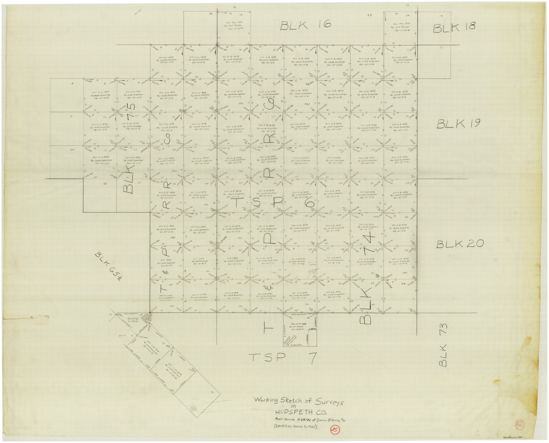
Hudspeth County Working Sketch 45
-
Map/Doc
66330
-
Collection
General Map Collection
-
Object Dates
3/9/1983 (Creation Date)
-
Counties
Hudspeth
-
Subjects
Surveying Working Sketch
-
Height x Width
34.7 x 43.2 inches
88.1 x 109.7 cm
Part of: General Map Collection
Outer Continental Shelf Leasing Maps (Texas Offshore Operations)

Print $20.00
- Digital $50.00
Outer Continental Shelf Leasing Maps (Texas Offshore Operations)
Size 17.0 x 18.4 inches
Map/Doc 75847
Atascosa County

Print $20.00
- Digital $50.00
Atascosa County
1948
Size 47.2 x 46.3 inches
Map/Doc 95421
Trinity County Boundary File 102

Print $14.00
- Digital $50.00
Trinity County Boundary File 102
Size 9.2 x 4.6 inches
Map/Doc 59480
Stonewall County Sketch File 13

Print $20.00
- Digital $50.00
Stonewall County Sketch File 13
1901
Size 22.4 x 18.8 inches
Map/Doc 12365
Map of Houston & Overton Branch Railroad

Print $40.00
- Digital $50.00
Map of Houston & Overton Branch Railroad
1877
Size 22.3 x 110.1 inches
Map/Doc 64460
Walker County Working Sketch 8

Print $20.00
- Digital $50.00
Walker County Working Sketch 8
1935
Size 40.8 x 41.7 inches
Map/Doc 72288
Jackson County Rolled Sketch 14

Print $20.00
- Digital $50.00
Jackson County Rolled Sketch 14
1978
Size 28.3 x 37.0 inches
Map/Doc 6345
Clay County Boundary File 5

Print $6.00
- Digital $50.00
Clay County Boundary File 5
Size 11.1 x 8.5 inches
Map/Doc 51373
Lubbock County Sketch File 1

Print $20.00
- Digital $50.00
Lubbock County Sketch File 1
1884
Size 22.5 x 27.6 inches
Map/Doc 12015
Outer Continental Shelf Leasing Maps (Louisiana Offshore Operations)

Print $20.00
- Digital $50.00
Outer Continental Shelf Leasing Maps (Louisiana Offshore Operations)
1954
Size 18.2 x 16.0 inches
Map/Doc 76105
Uvalde County Sketch File 3

Print $4.00
- Digital $50.00
Uvalde County Sketch File 3
1880
Size 9.1 x 15.0 inches
Map/Doc 38949
Walker County Working Sketch 6

Print $20.00
- Digital $50.00
Walker County Working Sketch 6
1935
Size 30.8 x 40.6 inches
Map/Doc 72286
You may also like
Montgomery County Working Sketch 49

Print $20.00
- Digital $50.00
Montgomery County Working Sketch 49
1959
Size 13.8 x 12.0 inches
Map/Doc 71156
[Sketch of area just south of Levi Pruitt survey]
![91855, [Sketch of area just south of Levi Pruitt survey], Twichell Survey Records](https://historictexasmaps.com/wmedia_w700/maps/91855-1.tif.jpg)
Print $20.00
- Digital $50.00
[Sketch of area just south of Levi Pruitt survey]
1924
Size 17.0 x 17.8 inches
Map/Doc 91855
Webb County Sketch File 6-2

Print $20.00
- Digital $50.00
Webb County Sketch File 6-2
1927
Size 29.4 x 21.3 inches
Map/Doc 12616
[Surveys in Austin's Colony at Matagorda Bay and along the Trespalacios and Colorado Rivers]
![147, [Surveys in Austin's Colony at Matagorda Bay and along the Trespalacios and Colorado Rivers], General Map Collection](https://historictexasmaps.com/wmedia_w700/maps/147.tif.jpg)
Print $20.00
- Digital $50.00
[Surveys in Austin's Colony at Matagorda Bay and along the Trespalacios and Colorado Rivers]
1821
Size 31.6 x 20.5 inches
Map/Doc 147
Fannin County Rolled Sketch 18B

Print $20.00
- Digital $50.00
Fannin County Rolled Sketch 18B
Size 12.7 x 16.1 inches
Map/Doc 5869
Hays County Sketch File 5

Print $4.00
- Digital $50.00
Hays County Sketch File 5
1847
Size 12.7 x 8.3 inches
Map/Doc 26206
Hays County Sketch File 10

Print $4.00
- Digital $50.00
Hays County Sketch File 10
1862
Size 8.2 x 10.7 inches
Map/Doc 26214
Polk County Sketch File 3

Print $10.00
- Digital $50.00
Polk County Sketch File 3
1848
Size 8.5 x 7.6 inches
Map/Doc 34122
Flight Mission No. BQR-12K, Frame 47, Brazoria County

Print $20.00
- Digital $50.00
Flight Mission No. BQR-12K, Frame 47, Brazoria County
1952
Size 18.7 x 22.4 inches
Map/Doc 84062

Township No. 1 South Range No. 25 West of the Indian Meridian

Print $20.00
- Digital $50.00
Township No. 1 South Range No. 25 West of the Indian Meridian
1875
Size 19.2 x 24.3 inches
Map/Doc 75248
Flight Mission No. CRE-1R, Frame 133, Jackson County

Print $20.00
- Digital $50.00
Flight Mission No. CRE-1R, Frame 133, Jackson County
1956
Size 16.2 x 16.2 inches
Map/Doc 85341