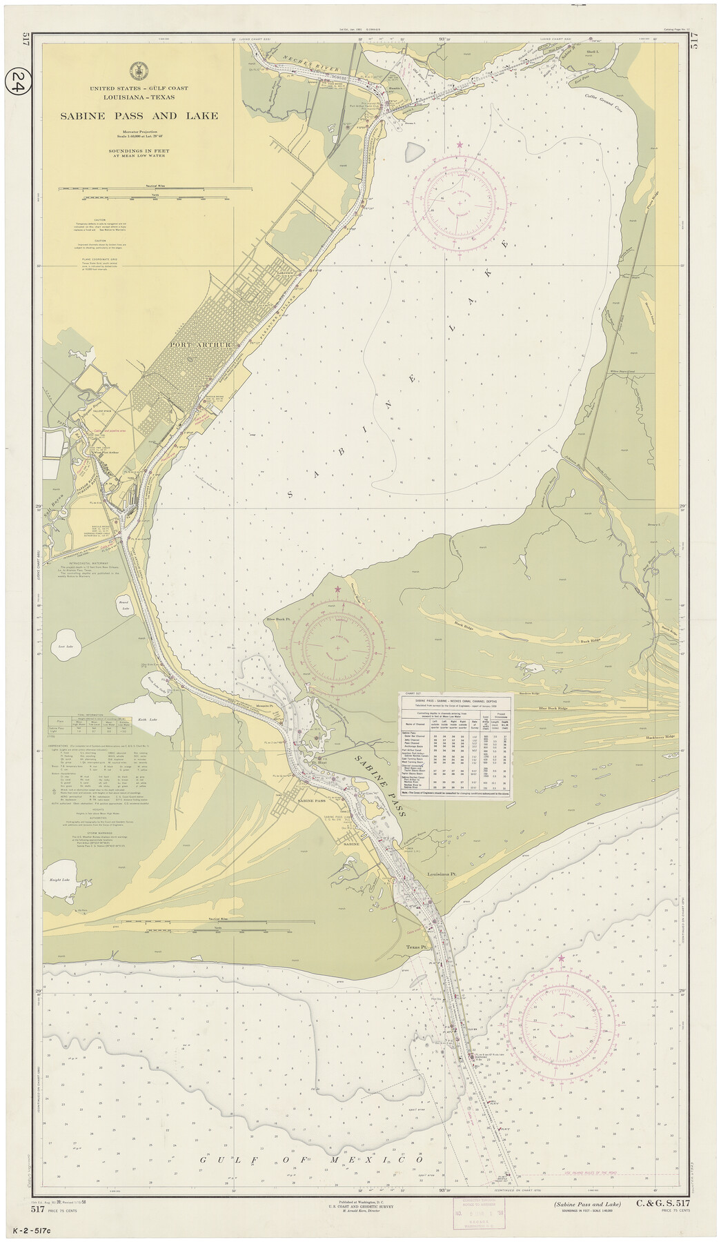
Sabine Pass and Lake
K-2-517a
-
Map/Doc
69823
-
Collection
General Map Collection
-
Object Dates
1958/1/13 (Creation Date)
-
Counties
Orange Jefferson
-
Subjects
Nautical Charts
-
Height x Width
47.1 x 27.5 inches
119.6 x 69.9 cm
Part of: General Map Collection
Nueces County Working Sketch Graphic Index

Print $20.00
- Digital $50.00
Nueces County Working Sketch Graphic Index
1913
Size 24.0 x 32.3 inches
Map/Doc 76655
Eastland County Sketch File 3

Print $4.00
- Digital $50.00
Eastland County Sketch File 3
1860
Size 10.2 x 8.3 inches
Map/Doc 21566
Liberty County Sketch File 41

Print $2.00
- Digital $50.00
Liberty County Sketch File 41
1872
Size 12.5 x 8.5 inches
Map/Doc 29997
Jefferson County NRC Article 33.136 Sketch 7

Print $24.00
- Digital $50.00
Jefferson County NRC Article 33.136 Sketch 7
2009
Size 30.8 x 43.0 inches
Map/Doc 94711
Map of Navisota County

Print $20.00
- Digital $50.00
Map of Navisota County
Size 27.5 x 19.6 inches
Map/Doc 3328
Sketch Showing Land Ties with Houston & Texas Central Railroad Through Harris County, Texas

Print $20.00
- Digital $50.00
Sketch Showing Land Ties with Houston & Texas Central Railroad Through Harris County, Texas
1880
Size 7.3 x 27.0 inches
Map/Doc 66739
Wichita County Rolled Sketch 11

Print $20.00
- Digital $50.00
Wichita County Rolled Sketch 11
Size 20.8 x 18.6 inches
Map/Doc 8248
[Map of Uvalde County]
![4108, [Map of Uvalde County], General Map Collection](https://historictexasmaps.com/wmedia_w700/maps/4108.tif.jpg)
Print $20.00
- Digital $50.00
[Map of Uvalde County]
1862
Size 27.7 x 26.7 inches
Map/Doc 4108
Crockett County Sketch File 80

Print $20.00
- Digital $50.00
Crockett County Sketch File 80
1939
Size 13.5 x 18.8 inches
Map/Doc 11236
Nueces County Sketch File 40

Print $6.00
- Digital $50.00
Nueces County Sketch File 40
1908
Size 13.9 x 8.7 inches
Map/Doc 32627
Texas in 1835

Print $20.00
- Digital $50.00
Texas in 1835
1897
Size 13.4 x 15.3 inches
Map/Doc 93414
Williamson County Working Sketch 9

Print $20.00
- Digital $50.00
Williamson County Working Sketch 9
1954
Size 31.2 x 30.0 inches
Map/Doc 72569
You may also like
Wichita County, Texas

Print $20.00
- Digital $50.00
Wichita County, Texas
1890
Size 26.9 x 32.1 inches
Map/Doc 679
Karnes County Sketch File 7a

Print $4.00
- Digital $50.00
Karnes County Sketch File 7a
1873
Size 10.1 x 8.1 inches
Map/Doc 28563
Sutton County Working Sketch 31

Print $20.00
- Digital $50.00
Sutton County Working Sketch 31
1929
Size 19.2 x 21.8 inches
Map/Doc 62374
Red River County Sketch File 17a

Print $4.00
- Digital $50.00
Red River County Sketch File 17a
1853
Size 12.6 x 8.1 inches
Map/Doc 35145
The great railroad routes to the Pacific, and their connections

Print $20.00
- Digital $50.00
The great railroad routes to the Pacific, and their connections
1869
Size 16.3 x 29.4 inches
Map/Doc 96974
Map of Central Europe engraved to illustrate Mitchell's new intermediate geography

Print $20.00
- Digital $50.00
Map of Central Europe engraved to illustrate Mitchell's new intermediate geography
1885
Size 9.0 x 12.2 inches
Map/Doc 93528
Duval County Sketch File 68

Print $20.00
- Digital $50.00
Duval County Sketch File 68
Size 23.9 x 19.6 inches
Map/Doc 11407
Flight Mission No. BRE-1P, Frame 94, Nueces County

Print $20.00
- Digital $50.00
Flight Mission No. BRE-1P, Frame 94, Nueces County
1956
Size 18.6 x 22.4 inches
Map/Doc 86665
Fannin County Boundary File 2

Print $27.00
- Digital $50.00
Fannin County Boundary File 2
Size 13.4 x 8.8 inches
Map/Doc 53282
Armstrong County

Print $20.00
- Digital $50.00
Armstrong County
1933
Size 42.3 x 41.0 inches
Map/Doc 73071
Angelina County Sketch File 29

Print $4.00
- Digital $50.00
Angelina County Sketch File 29
1911
Size 8.0 x 8.4 inches
Map/Doc 13087
Mitchell Estate Subdivision

Print $20.00
- Digital $50.00
Mitchell Estate Subdivision
1953
Size 9.3 x 19.8 inches
Map/Doc 92505