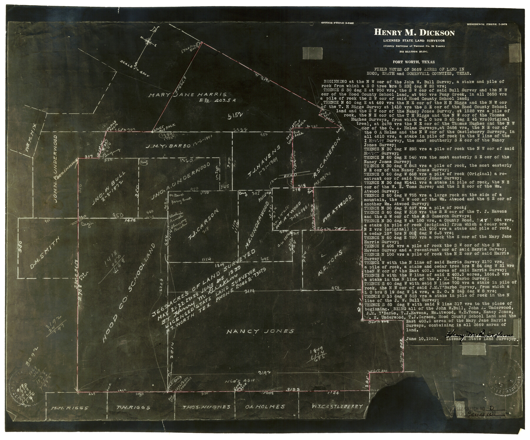
Somervell County Rolled Sketch D
Field notes and sketch of 3669 acres of land in Hood, Erath, and Somervell Counties, Texas
-
Map/Doc
7794
-
Collection
General Map Collection
-
Object Dates
6/10/1939 (Creation Date)
5/13/1940 (File Date)
-
People and Organizations
Henry M. Dickson (Surveyor/Engineer)
-
Counties
Somervell Hood Erath
-
Subjects
Surveying Rolled Sketch
-
Height x Width
17.3 x 21.0 inches
43.9 x 53.3 cm
-
Medium
photostat
Related maps
Somervell County Sketch File 6

Print $6.00
- Digital $50.00
Somervell County Sketch File 6
1939
Size 13.6 x 8.6 inches
Map/Doc 36847
Part of: General Map Collection
Trinity County Working Sketch 12

Print $20.00
- Digital $50.00
Trinity County Working Sketch 12
1950
Size 46.6 x 36.9 inches
Map/Doc 69461
Liberty County Working Sketch 29

Print $20.00
- Digital $50.00
Liberty County Working Sketch 29
1943
Size 27.3 x 17.0 inches
Map/Doc 70488
Right of Way and Track Map - Houston & Texas Central R.R. operated by the T. and N. O. R.R. Co. - Main Line

Print $40.00
- Digital $50.00
Right of Way and Track Map - Houston & Texas Central R.R. operated by the T. and N. O. R.R. Co. - Main Line
1918
Size 25.0 x 57.5 inches
Map/Doc 82857
Taylor County Rolled Sketch 30A

Print $20.00
- Digital $50.00
Taylor County Rolled Sketch 30A
Size 17.5 x 11.3 inches
Map/Doc 76410
Ochiltree County Boundary File 1

Print $14.00
- Digital $50.00
Ochiltree County Boundary File 1
Size 12.7 x 8.2 inches
Map/Doc 57657
Flight Mission No. CLL-3N, Frame 38, Willacy County

Print $20.00
- Digital $50.00
Flight Mission No. CLL-3N, Frame 38, Willacy County
1954
Size 18.6 x 22.2 inches
Map/Doc 87096
Map of Colorado County

Print $20.00
- Digital $50.00
Map of Colorado County
1871
Size 18.4 x 19.1 inches
Map/Doc 4594
Jasper County

Print $40.00
- Digital $50.00
Jasper County
1898
Size 64.2 x 35.6 inches
Map/Doc 78413
Galveston County NRC Article 33.136 Sketch 30

Print $20.00
- Digital $50.00
Galveston County NRC Article 33.136 Sketch 30
2005
Size 12.1 x 15.5 inches
Map/Doc 82997
Sectional Map No. 2 of the lands and the line of the Texas & Pacific Ry. Co. in Howard, Martin, Andrews, Midland and Tom Green Counties

Print $20.00
- Digital $50.00
Sectional Map No. 2 of the lands and the line of the Texas & Pacific Ry. Co. in Howard, Martin, Andrews, Midland and Tom Green Counties
1885
Size 18.9 x 23.4 inches
Map/Doc 4859
Pecos County Texas

Print $20.00
- Digital $50.00
Pecos County Texas
Size 23.6 x 19.3 inches
Map/Doc 3950
Flight Mission No. DIX-8P, Frame 96, Aransas County

Print $20.00
- Digital $50.00
Flight Mission No. DIX-8P, Frame 96, Aransas County
1956
Size 18.4 x 22.2 inches
Map/Doc 83921
You may also like
Map of San Patricio County

Print $40.00
- Digital $50.00
Map of San Patricio County
1896
Size 31.6 x 51.2 inches
Map/Doc 63018
Trinity County Rolled Sketch 4

Print $20.00
- Digital $50.00
Trinity County Rolled Sketch 4
1948
Size 38.5 x 42.4 inches
Map/Doc 10026
Montague County Working Sketch 32

Print $20.00
- Digital $50.00
Montague County Working Sketch 32
1975
Size 26.0 x 26.1 inches
Map/Doc 71098
Tarrant's Key and Guide to Dallas

Print $3.00
- Digital $50.00
Tarrant's Key and Guide to Dallas
1922
Size 7.9 x 10.3 inches
Map/Doc 89275
Erath County Working Sketch 2

Print $20.00
- Digital $50.00
Erath County Working Sketch 2
Size 18.0 x 22.6 inches
Map/Doc 69083
Medina County Working Sketch 17

Print $20.00
- Digital $50.00
Medina County Working Sketch 17
1979
Size 26.8 x 34.5 inches
Map/Doc 70932
Township 6 North Range 13 West, North Western District, Louisiana

Print $20.00
- Digital $50.00
Township 6 North Range 13 West, North Western District, Louisiana
1841
Size 19.7 x 24.8 inches
Map/Doc 65864
Jim Hogg County Working Sketch Graphic Index

Print $20.00
- Digital $50.00
Jim Hogg County Working Sketch Graphic Index
1962
Size 40.0 x 28.7 inches
Map/Doc 76596
DeWitt County Working Sketch 12

Print $20.00
- Digital $50.00
DeWitt County Working Sketch 12
1981
Size 17.0 x 12.5 inches
Map/Doc 68602
Topographical Map of the country between San Antonio & Colorado Rivers in the State of Texas.

Print $40.00
Topographical Map of the country between San Antonio & Colorado Rivers in the State of Texas.
1864
Size 53.2 x 74.8 inches
Map/Doc 88606
Map Showing Lands Surveyed by Sylvan Sanders, Block D

Print $20.00
- Digital $50.00
Map Showing Lands Surveyed by Sylvan Sanders, Block D
Size 28.2 x 23.5 inches
Map/Doc 92440
Edwards County

Print $20.00
- Digital $50.00
Edwards County
1893
Size 30.8 x 33.1 inches
Map/Doc 3507