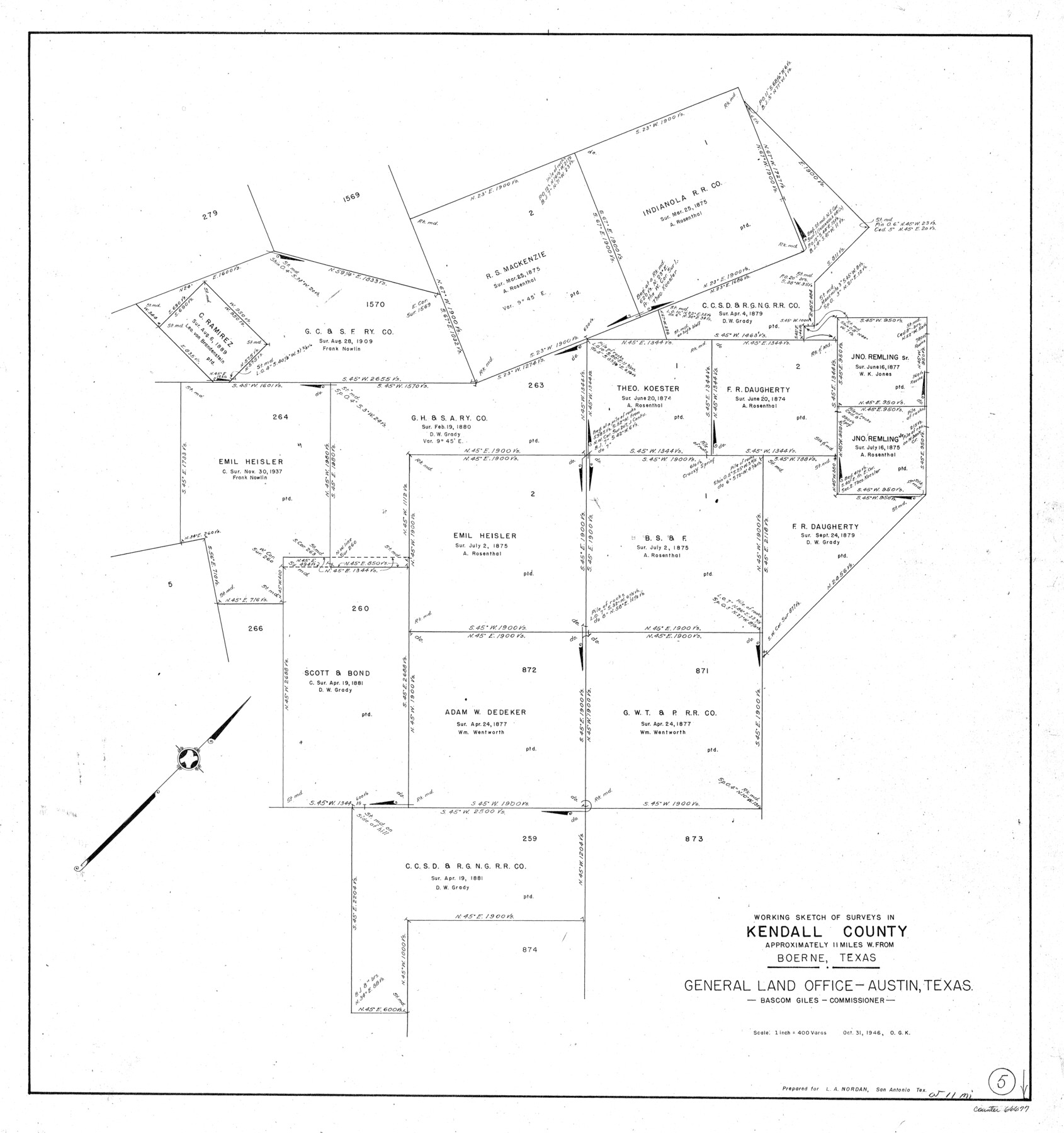
Kendall County Working Sketch 5
-
Map/Doc
66677
-
Collection
General Map Collection
-
Object Dates
10/31/1946 (Creation Date)
-
People and Organizations
Otto G. Kurio (Draftsman)
-
Counties
Kendall
-
Subjects
Surveying Working Sketch
-
Height x Width
30.4 x 28.6 inches
77.2 x 72.6 cm
-
Scale
1" = 400 varas
Part of: General Map Collection
Crane County Sketch File A10

Print $20.00
- Digital $50.00
Crane County Sketch File A10
Size 18.0 x 24.7 inches
Map/Doc 11214
Live Oak County Working Sketch 32

Print $20.00
- Digital $50.00
Live Oak County Working Sketch 32
1992
Size 12.0 x 16.7 inches
Map/Doc 70617
Territory of New Mexico

Print $20.00
- Digital $50.00
Territory of New Mexico
1903
Size 23.8 x 19.6 inches
Map/Doc 82011
Flight Mission No. DCL-5C, Frame 28, Kenedy County

Print $20.00
- Digital $50.00
Flight Mission No. DCL-5C, Frame 28, Kenedy County
1943
Size 18.5 x 22.3 inches
Map/Doc 85840
Flight Mission No. CRE-2R, Frame 167, Jackson County

Print $20.00
- Digital $50.00
Flight Mission No. CRE-2R, Frame 167, Jackson County
1956
Size 18.6 x 22.4 inches
Map/Doc 85377
Crockett County Rolled Sketch 46A

Print $40.00
- Digital $50.00
Crockett County Rolled Sketch 46A
Size 43.4 x 63.9 inches
Map/Doc 9199
Railroad Track Map, H&TCRRCo., Falls County, Texas

Print $4.00
- Digital $50.00
Railroad Track Map, H&TCRRCo., Falls County, Texas
1918
Size 11.7 x 18.7 inches
Map/Doc 62841
Nueces County Sketch File 73

Print $4.00
- Digital $50.00
Nueces County Sketch File 73
1991
Size 11.1 x 8.8 inches
Map/Doc 33026
Gaines County Working Sketch 7

Print $20.00
- Digital $50.00
Gaines County Working Sketch 7
1940
Size 16.5 x 38.5 inches
Map/Doc 69307
[Map of Surveys in Dallam, Texas]
![1768, [Map of Surveys in Dallam, Texas], General Map Collection](https://historictexasmaps.com/wmedia_w700/maps/1768.tif.jpg)
Print $20.00
- Digital $50.00
[Map of Surveys in Dallam, Texas]
1910
Size 19.5 x 27.8 inches
Map/Doc 1768
Northeast Part of Webb County

Print $40.00
- Digital $50.00
Northeast Part of Webb County
1986
Size 38.0 x 49.2 inches
Map/Doc 73318
That part of the boundary between the Republic of Texas and the United States, North of Sabine River from the 36th to the 72nd Mile Mound on the Meridian Line (Sheet No. 2)

Print $20.00
- Digital $50.00
That part of the boundary between the Republic of Texas and the United States, North of Sabine River from the 36th to the 72nd Mile Mound on the Meridian Line (Sheet No. 2)
1842
Size 33.7 x 26.0 inches
Map/Doc 3132
You may also like
Right of Way and Track Map, Texas & New Orleans R.R. operated by the T. & N. O. R.R. Co., Rusk Branch

Print $40.00
- Digital $50.00
Right of Way and Track Map, Texas & New Orleans R.R. operated by the T. & N. O. R.R. Co., Rusk Branch
1918
Size 24.7 x 56.2 inches
Map/Doc 64243
J. De Cordova's Map of the State of Texas Compiled from the records of the General Land Office of the State

Print $20.00
J. De Cordova's Map of the State of Texas Compiled from the records of the General Land Office of the State
1872
Size 34.3 x 31.9 inches
Map/Doc 76216
Map of Jack County, State of Texas : exhibiting the extent of public surveys land grants and all other official information compiled from official surveys of the Genral Land Office at Austin…

Print $20.00
Map of Jack County, State of Texas : exhibiting the extent of public surveys land grants and all other official information compiled from official surveys of the Genral Land Office at Austin…
1876
Size 16.5 x 15.4 inches
Map/Doc 93591
Flight Mission No. DAG-24K, Frame 141, Matagorda County

Print $20.00
- Digital $50.00
Flight Mission No. DAG-24K, Frame 141, Matagorda County
1953
Size 18.5 x 22.4 inches
Map/Doc 86559
Wharton County Sketch File 23

Print $20.00
- Digital $50.00
Wharton County Sketch File 23
Size 19.3 x 19.9 inches
Map/Doc 12667
Upton County Working Sketch 32

Print $40.00
- Digital $50.00
Upton County Working Sketch 32
1956
Size 55.4 x 37.9 inches
Map/Doc 69528
Stephens County Working Sketch 26

Print $20.00
- Digital $50.00
Stephens County Working Sketch 26
1976
Size 36.9 x 32.2 inches
Map/Doc 63969
Van Zandt County Rolled Sketch 6

Print $3.00
- Digital $50.00
Van Zandt County Rolled Sketch 6
1946
Size 9.3 x 11.3 inches
Map/Doc 10311
Matagorda County Rolled Sketch 37C

Print $20.00
- Digital $50.00
Matagorda County Rolled Sketch 37C
Size 11.6 x 14.3 inches
Map/Doc 10197
King County Working Sketch 10

Print $20.00
- Digital $50.00
King County Working Sketch 10
1956
Size 19.1 x 13.9 inches
Map/Doc 70174
Presidio County Working Sketch 1

Print $20.00
- Digital $50.00
Presidio County Working Sketch 1
Size 37.4 x 20.4 inches
Map/Doc 71675
Donley County Sketch File 27

Print $4.00
- Digital $50.00
Donley County Sketch File 27
Size 7.7 x 12.1 inches
Map/Doc 21264