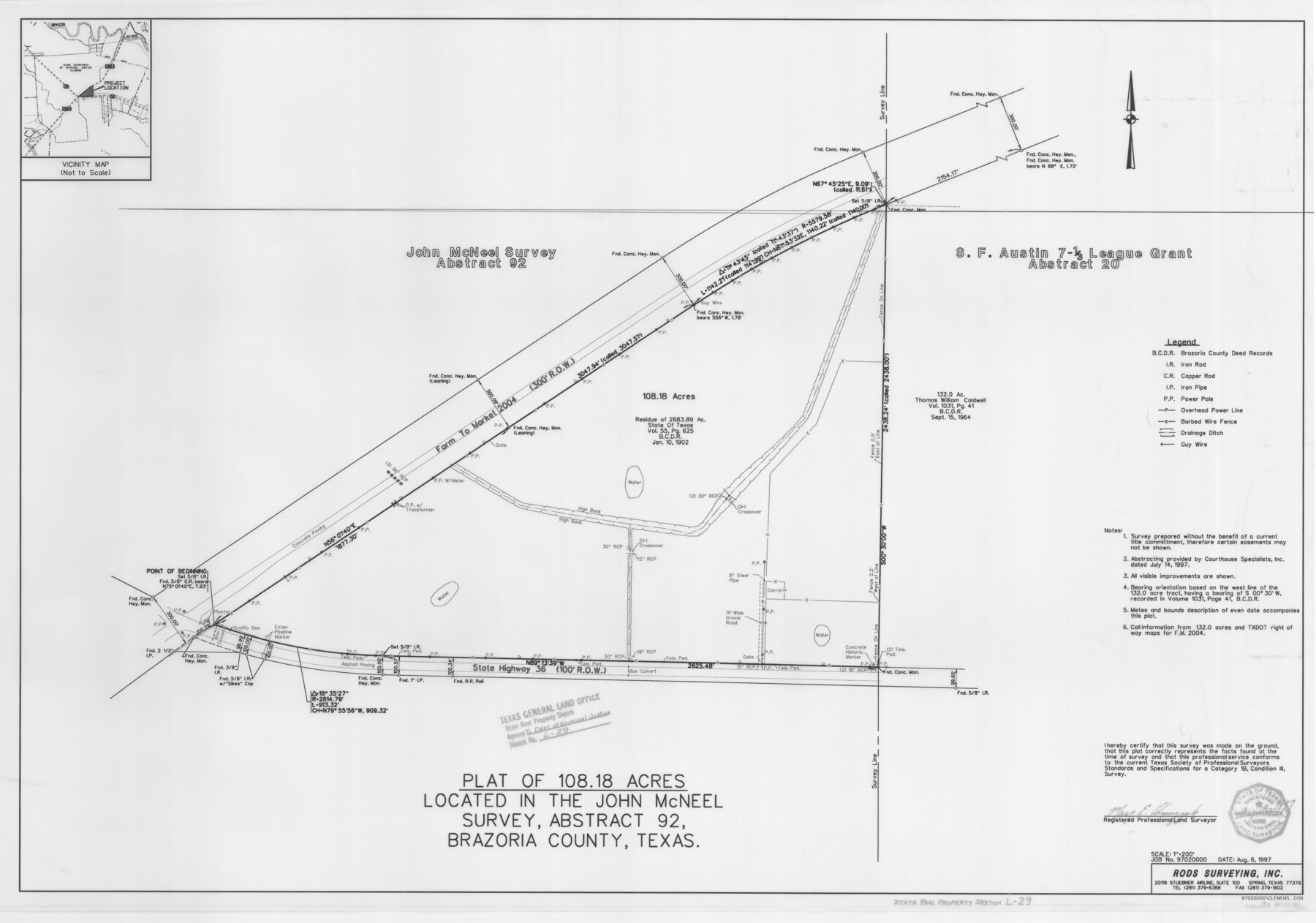
Brazoria County State Real Property Sketch 1
A Plat of 108.18 Acres Located in the John McNeel Survey, A - 92
State Real Property Sketch L - 29
-
Map/Doc
80127
-
Collection
General Map Collection
-
Object Dates
1997/8/6 (Creation Date)
2003/3/20 (File Date)
-
People and Organizations
Rods Surveying, Inc. (Publisher)
Rods Surveying, Inc. (Printer)
Mary E. Chruzyak (Surveyor/Engineer)
-
Counties
Brazoria
-
Subjects
State Real Property
-
Height x Width
24.4 x 34.8 inches
62.0 x 88.4 cm
-
Comments
Surveys located about 14 1/2 miles South 17 degrees West of Angleton, Texas.
Part of: General Map Collection
Concho County Sketch File 8 1/2

Print $8.00
- Digital $50.00
Concho County Sketch File 8 1/2
1887
Size 8.4 x 10.6 inches
Map/Doc 19134
Garza County Sketch File 5

Print $14.00
- Digital $50.00
Garza County Sketch File 5
1885
Size 9.8 x 8.1 inches
Map/Doc 24050
Hamilton County Working Sketch 2

Print $20.00
- Digital $50.00
Hamilton County Working Sketch 2
1923
Size 12.9 x 15.7 inches
Map/Doc 63340
Hutchinson County Rolled Sketch 44-13

Print $20.00
- Digital $50.00
Hutchinson County Rolled Sketch 44-13
2002
Size 24.0 x 36.0 inches
Map/Doc 77549
Bexar County Rolled Sketch 4

Print $20.00
- Digital $50.00
Bexar County Rolled Sketch 4
Size 24.3 x 36.8 inches
Map/Doc 5137
Gillespie County Rolled Sketch 3

Print $20.00
- Digital $50.00
Gillespie County Rolled Sketch 3
Size 19.0 x 28.1 inches
Map/Doc 6010
Baylor County Boundary File 9

Print $4.00
- Digital $50.00
Baylor County Boundary File 9
Size 11.2 x 8.7 inches
Map/Doc 50407
Refugio County Boundary File 74

Print $172.00
- Digital $50.00
Refugio County Boundary File 74
Size 9.3 x 4.4 inches
Map/Doc 58272
McMullen County Sketch File 2

Print $22.00
- Digital $50.00
McMullen County Sketch File 2
1849
Size 8.3 x 12.4 inches
Map/Doc 31337
North Shore of West Bay and Galveston Island

Print $40.00
- Digital $50.00
North Shore of West Bay and Galveston Island
1933
Size 36.4 x 56.9 inches
Map/Doc 69931
Gonzales County Working Sketch 2

Print $20.00
- Digital $50.00
Gonzales County Working Sketch 2
1920
Size 17.6 x 21.5 inches
Map/Doc 63217
Travis County

Print $40.00
- Digital $50.00
Travis County
1880
Size 62.1 x 50.2 inches
Map/Doc 87935
You may also like

Flight Mission No. DIX-10P, Frame 72, Aransas County

Print $20.00
- Digital $50.00
Flight Mission No. DIX-10P, Frame 72, Aransas County
1956
Size 18.8 x 22.4 inches
Map/Doc 83933
The Chief Justice County of Victoria. September 20, 1837

Print $20.00
The Chief Justice County of Victoria. September 20, 1837
2020
Size 23.3 x 21.7 inches
Map/Doc 96075
McMullen County Sketch File 2
Print $22.00
- Digital $50.00
McMullen County Sketch File 2
1849
Size 8.3 x 12.4 inches
Map/Doc 31337
Flight Mission No. DQN-2K, Frame 80, Calhoun County

Print $20.00
- Digital $50.00
Flight Mission No. DQN-2K, Frame 80, Calhoun County
1953
Size 18.4 x 22.2 inches
Map/Doc 84272
Primera parte del Mapa, que comprende la Frontera, de los Dominios del Rey, en la America Septentrional

Print $40.00
- Digital $50.00
Primera parte del Mapa, que comprende la Frontera, de los Dominios del Rey, en la America Septentrional
1769
Size 25.8 x 63.2 inches
Map/Doc 3062
Dimmit County Working Sketch 39

Print $20.00
- Digital $50.00
Dimmit County Working Sketch 39
1967
Size 25.5 x 30.0 inches
Map/Doc 68700
Harris County Rolled Sketch 87A

Print $20.00
- Digital $50.00
Harris County Rolled Sketch 87A
Size 41.1 x 47.6 inches
Map/Doc 78250
Flight Mission No. DIX-5P, Frame 146, Aransas County

Print $20.00
- Digital $50.00
Flight Mission No. DIX-5P, Frame 146, Aransas County
1956
Size 17.7 x 17.9 inches
Map/Doc 83808
Milam County Working Sketch 4

Print $20.00
- Digital $50.00
Milam County Working Sketch 4
1954
Size 26.1 x 32.4 inches
Map/Doc 71019
Travis County Working Sketch 24

Print $20.00
- Digital $50.00
Travis County Working Sketch 24
1948
Size 25.6 x 23.1 inches
Map/Doc 69408
Flight Mission No. BQR-16K, Frame 32, Brazoria County

Print $20.00
- Digital $50.00
Flight Mission No. BQR-16K, Frame 32, Brazoria County
1952
Size 18.5 x 22.2 inches
Map/Doc 84099