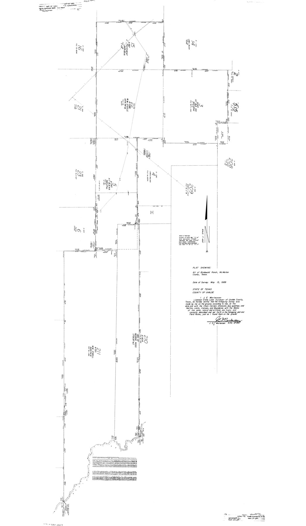
McMullen County Rolled Sketch 21
Plat showing all of Bindewald Ranch, McMullen County, Texas
-
Map/Doc
9502
-
Collection
General Map Collection
-
Object Dates
1989/5/15 (Survey Date)
1989/5/29 (File Date)
-
People and Organizations
James E. Mortensen (Surveyor/Engineer)
-
Counties
McMullen
-
Subjects
Surveying Rolled Sketch
-
Height x Width
68.9 x 40.0 inches
175.0 x 101.6 cm
-
Medium
mylar, print
-
Scale
1" = 600 feet
Part of: General Map Collection
Crane County Working Sketch Graphic Index, Sheet B

Print $20.00
- Digital $50.00
Crane County Working Sketch Graphic Index, Sheet B
1945
Size 44.8 x 33.6 inches
Map/Doc 76508
Map of Denton County

Print $20.00
- Digital $50.00
Map of Denton County
1897
Size 45.0 x 41.2 inches
Map/Doc 66802
Flight Mission No. CGI-4N, Frame 159, Cameron County

Print $20.00
- Digital $50.00
Flight Mission No. CGI-4N, Frame 159, Cameron County
1955
Size 18.7 x 22.2 inches
Map/Doc 84667
Frio County Sketch File 18

Print $8.00
- Digital $50.00
Frio County Sketch File 18
1961
Size 14.3 x 8.9 inches
Map/Doc 23155
Brewster County Rolled Sketch 97

Print $20.00
- Digital $50.00
Brewster County Rolled Sketch 97
1952
Size 31.6 x 30.7 inches
Map/Doc 5254
Webb County Rolled Sketch 78

Print $20.00
- Digital $50.00
Webb County Rolled Sketch 78
2011
Size 33.1 x 24.6 inches
Map/Doc 90052
Blanco County Working Sketch 21

Print $20.00
- Digital $50.00
Blanco County Working Sketch 21
1960
Size 34.1 x 29.2 inches
Map/Doc 67381
Loving County Sketch File 6

Print $10.00
- Digital $50.00
Loving County Sketch File 6
1963
Size 7.2 x 5.9 inches
Map/Doc 41451
Brewster County Rolled Sketch 47

Print $20.00
- Digital $50.00
Brewster County Rolled Sketch 47
1930
Size 18.1 x 41.0 inches
Map/Doc 5223
Fort Parker State Park

Print $20.00
- Digital $50.00
Fort Parker State Park
1950
Size 26.0 x 37.8 inches
Map/Doc 73569
Freestone County Sketch File 28

Print $12.00
- Digital $50.00
Freestone County Sketch File 28
2002
Size 11.2 x 8.9 inches
Map/Doc 78602
Loving County Working Sketch 23

Print $20.00
- Digital $50.00
Loving County Working Sketch 23
1952
Size 15.1 x 31.5 inches
Map/Doc 70657
You may also like
[Texas Boundary Line]
![92073, [Texas Boundary Line], Twichell Survey Records](https://historictexasmaps.com/wmedia_w700/maps/92073-1.tif.jpg)
Print $20.00
- Digital $50.00
[Texas Boundary Line]
Size 21.5 x 11.9 inches
Map/Doc 92073
Montgomery County Rolled Sketch 37

Print $40.00
- Digital $50.00
Montgomery County Rolled Sketch 37
Size 44.3 x 52.7 inches
Map/Doc 9544
San Saba County

Print $40.00
- Digital $50.00
San Saba County
1918
Size 49.0 x 43.0 inches
Map/Doc 63023
University of Texas System University Lands

Print $20.00
- Digital $50.00
University of Texas System University Lands
Size 23.0 x 17.5 inches
Map/Doc 93240
Val Verde County Rolled Sketch 44

Print $61.00
- Digital $50.00
Val Verde County Rolled Sketch 44
Size 10.2 x 15.3 inches
Map/Doc 49454
McLennan County Sketch File 1

Print $4.00
- Digital $50.00
McLennan County Sketch File 1
Size 11.5 x 8.4 inches
Map/Doc 31224
Stephens County Sketch File 2

Print $4.00
- Digital $50.00
Stephens County Sketch File 2
1870
Size 12.9 x 8.2 inches
Map/Doc 37013
Colorado County Sketch File 16a

Print $4.00
- Digital $50.00
Colorado County Sketch File 16a
Size 12.7 x 8.1 inches
Map/Doc 18947
Flight Mission No. DQO-14T, Frame 65, Galveston County

Print $20.00
- Digital $50.00
Flight Mission No. DQO-14T, Frame 65, Galveston County
1958
Size 17.6 x 17.4 inches
Map/Doc 85216
Shelby County Rolled Sketch 8

Print $20.00
- Digital $50.00
Shelby County Rolled Sketch 8
Size 40.4 x 45.5 inches
Map/Doc 9923
[Map of Lt. Brulls scout in Haskell, Throckmorton, Jones and Shackelford Counties]
![65399, [Map of Lt. Brulls scout in Haskell, Throckmorton, Jones and Shackelford Counties], General Map Collection](https://historictexasmaps.com/wmedia_w700/maps/65399-1.tif.jpg)
Print $3.00
- Digital $50.00
[Map of Lt. Brulls scout in Haskell, Throckmorton, Jones and Shackelford Counties]
1873
Size 10.1 x 11.9 inches
Map/Doc 65399
Uvalde County Rolled Sketch 16

Print $20.00
- Digital $50.00
Uvalde County Rolled Sketch 16
Size 36.6 x 25.1 inches
Map/Doc 8100