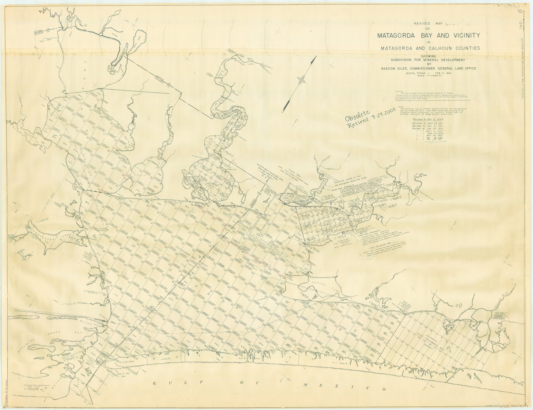
Revised Map of Matagorda Bay and Vicinity in Matagorda and Calhoun Counties, showing Subdivision for Mineral Development
-
Map/Doc
1910
-
Collection
General Map Collection
-
Object Dates
1959 (Creation Date)
-
People and Organizations
General Land Office (Publisher)
-
Subjects
Energy Offshore Submerged Area
-
Height x Width
43.8 x 57.0 inches
111.3 x 144.8 cm
-
Medium
blueline cloth
-
Scale
4000 feet
-
Comments
Gulf coast and submerged state lands. Revised March 16, 1959.
Part of: General Map Collection
[Map of Jackson County]
![78359, [Map of Jackson County], General Map Collection](https://historictexasmaps.com/wmedia_w700/maps/78359.tif.jpg)
Print $20.00
- Digital $50.00
[Map of Jackson County]
1836
Size 32.8 x 21.1 inches
Map/Doc 78359
Permanent Lakes and Marshes in Calhoun, Victoria and Jackson Cos. for Mineral Development

Print $20.00
- Digital $50.00
Permanent Lakes and Marshes in Calhoun, Victoria and Jackson Cos. for Mineral Development
1937
Size 36.9 x 38.9 inches
Map/Doc 2973
Wharton County Sketch File 6

Print $4.00
- Digital $50.00
Wharton County Sketch File 6
1877
Size 8.6 x 14.2 inches
Map/Doc 39923
Hays County Sketch File 30

Print $12.00
- Digital $50.00
Hays County Sketch File 30
1938
Size 14.3 x 9.0 inches
Map/Doc 26255
Flight Mission No. CZW-2R, Frame 66, Hardeman County

Print $20.00
- Digital $50.00
Flight Mission No. CZW-2R, Frame 66, Hardeman County
1956
Size 18.6 x 22.4 inches
Map/Doc 85239
Llano County Working Sketch 1

Print $20.00
- Digital $50.00
Llano County Working Sketch 1
1938
Size 19.5 x 19.2 inches
Map/Doc 70619
Nueces County Sketch File 80

Print $102.00
- Digital $50.00
Nueces County Sketch File 80
1997
Size 11.0 x 8.5 inches
Map/Doc 33104
Midland County Rolled Sketch 13

Print $20.00
- Digital $50.00
Midland County Rolled Sketch 13
Size 22.0 x 19.4 inches
Map/Doc 6768
Galveston County Sketch File 51

Print $20.00
- Digital $50.00
Galveston County Sketch File 51
1895
Size 25.7 x 40.2 inches
Map/Doc 10457

Flight Mission No. BQY-4M, Frame 120, Harris County

Print $20.00
- Digital $50.00
Flight Mission No. BQY-4M, Frame 120, Harris County
1953
Size 18.5 x 22.3 inches
Map/Doc 85288
Henderson County Working Sketch 15

Print $20.00
- Digital $50.00
Henderson County Working Sketch 15
1935
Size 18.3 x 18.1 inches
Map/Doc 66148
You may also like
Harris County Historic Topographic 3

Print $20.00
- Digital $50.00
Harris County Historic Topographic 3
1916
Size 29.4 x 22.5 inches
Map/Doc 65813
Culberson County Working Sketch 59

Print $20.00
- Digital $50.00
Culberson County Working Sketch 59
1974
Size 46.4 x 37.7 inches
Map/Doc 68513
Dawson County Sketch File 6

Print $72.00
- Digital $50.00
Dawson County Sketch File 6
1927
Size 24.6 x 24.7 inches
Map/Doc 20518
Map of Kinney County

Print $20.00
- Digital $50.00
Map of Kinney County
1876
Size 24.0 x 32.4 inches
Map/Doc 3775
Chambers County Rolled Sketch 23A

Print $40.00
- Digital $50.00
Chambers County Rolled Sketch 23A
1940
Size 77.1 x 36.0 inches
Map/Doc 8592
McLennan County Sketch File 4

Print $4.00
- Digital $50.00
McLennan County Sketch File 4
1852
Size 12.7 x 8.2 inches
Map/Doc 31235
Wheeler County Sketch File 2

Print $26.00
- Digital $50.00
Wheeler County Sketch File 2
1881
Size 19.0 x 7.9 inches
Map/Doc 39994
Cogdell Ranch Kent County, Texas

Print $20.00
- Digital $50.00
Cogdell Ranch Kent County, Texas
1950
Size 36.3 x 19.2 inches
Map/Doc 92188
El Paso County Rolled Sketch 64

Print $246.00
- Digital $50.00
El Paso County Rolled Sketch 64
1993
Size 11.3 x 8.7 inches
Map/Doc 41531
Knox County Sketch File 11

Print $20.00
- Digital $50.00
Knox County Sketch File 11
1892
Size 26.8 x 21.9 inches
Map/Doc 11959
Orange County Working Sketch 13

Print $20.00
- Digital $50.00
Orange County Working Sketch 13
1922
Size 12.9 x 15.5 inches
Map/Doc 71345
Sterling County Rolled Sketch 11

Print $20.00
- Digital $50.00
Sterling County Rolled Sketch 11
1884
Size 22.5 x 46.6 inches
Map/Doc 9945