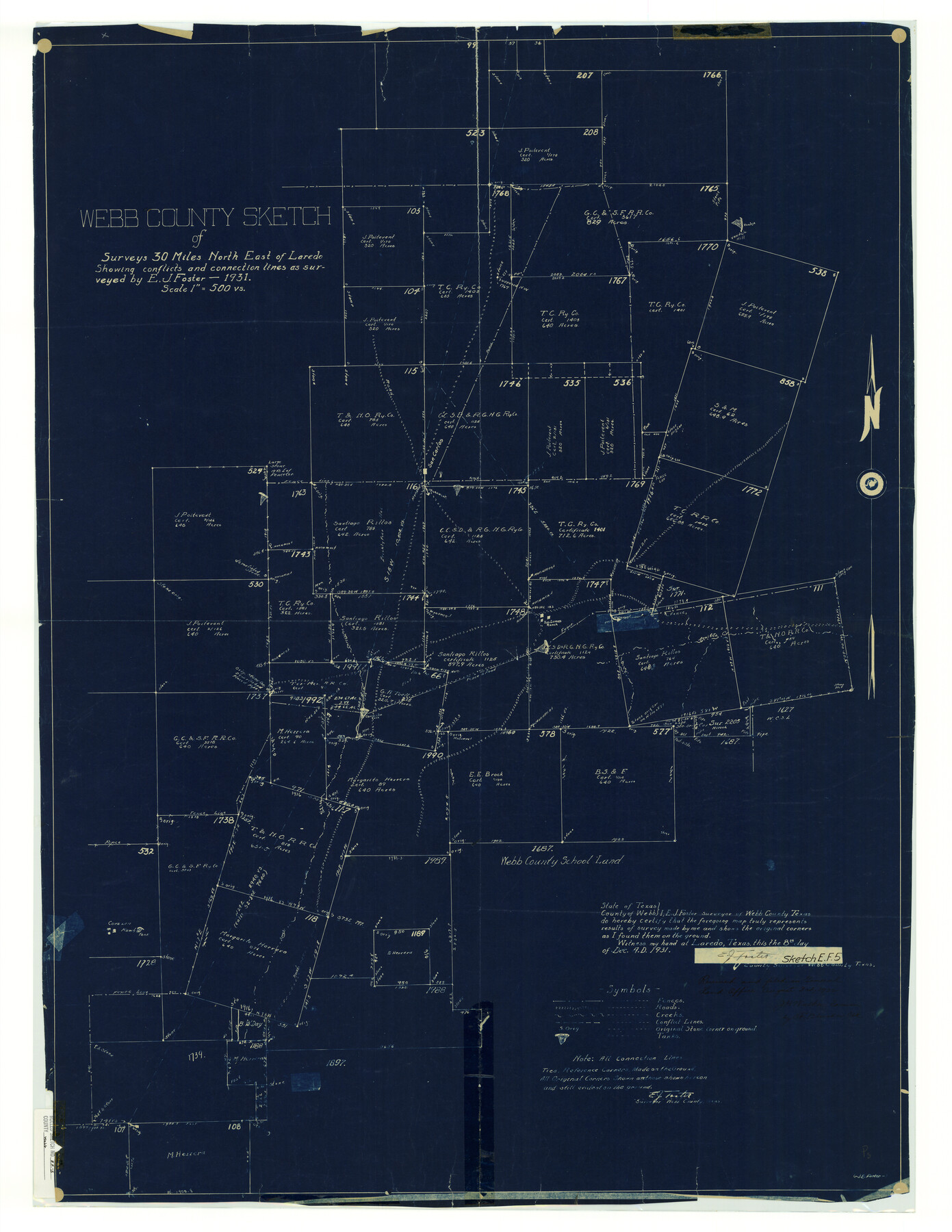
Webb County Rolled Sketch EF5
Webb County sketch of surveys 30 miles north east of Laredo showing conflicts and connection lines as surveyed
-
Map/Doc
8227
-
Collection
General Map Collection
-
Object Dates
1931 (Survey Date)
1932/8/3 (File Date)
1931/12/8 (Creation Date)
-
People and Organizations
E.J. Foster (Surveyor/Engineer)
-
Counties
Webb
-
Subjects
Surveying Rolled Sketch
-
Height x Width
41.4 x 32.0 inches
105.2 x 81.3 cm
-
Medium
blueprint/diazo
-
Scale
1" = 500 varas
Related maps
Webb County Sketch File EF

Print $38.00
- Digital $50.00
Webb County Sketch File EF
1932
Size 9.2 x 8.5 inches
Map/Doc 39681
Part of: General Map Collection
Map of Hill County

Print $40.00
- Digital $50.00
Map of Hill County
1884
Size 48.4 x 37.7 inches
Map/Doc 4979
Limestone County Sketch File 11

Print $4.00
- Digital $50.00
Limestone County Sketch File 11
1881
Size 7.9 x 9.5 inches
Map/Doc 30177
Lampasas County Boundary File 11

Print $4.00
- Digital $50.00
Lampasas County Boundary File 11
Size 14.0 x 8.6 inches
Map/Doc 56189
Hunt County Sketch File A

Print $4.00
- Digital $50.00
Hunt County Sketch File A
1884
Size 14.4 x 8.3 inches
Map/Doc 27170
Winkler County Working Sketch 1

Print $20.00
- Digital $50.00
Winkler County Working Sketch 1
1944
Size 17.5 x 38.9 inches
Map/Doc 72595
Texas State Boundary Line 6

Print $10.00
- Digital $50.00
Texas State Boundary Line 6
2000
Size 11.3 x 8.8 inches
Map/Doc 75046
Galveston County NRC Article 33.136 Sketch 67

Print $28.00
- Digital $50.00
Galveston County NRC Article 33.136 Sketch 67
2011
Size 17.0 x 24.0 inches
Map/Doc 93391
[Surveys in Austin's Colony along the San Bernardo River from the mouth of Peach Creek]
![209, [Surveys in Austin's Colony along the San Bernardo River from the mouth of Peach Creek], General Map Collection](https://historictexasmaps.com/wmedia_w700/maps/209.tif.jpg)
Print $20.00
- Digital $50.00
[Surveys in Austin's Colony along the San Bernardo River from the mouth of Peach Creek]
1821
Size 23.4 x 10.6 inches
Map/Doc 209
Limestone County Working Sketch 17

Print $20.00
- Digital $50.00
Limestone County Working Sketch 17
1959
Size 42.2 x 33.1 inches
Map/Doc 70567
Henderson County Working Sketch 30

Print $20.00
- Digital $50.00
Henderson County Working Sketch 30
1962
Size 44.5 x 43.8 inches
Map/Doc 66163
Collin County Working Sketch 5

Print $20.00
- Digital $50.00
Collin County Working Sketch 5
1992
Size 14.2 x 19.7 inches
Map/Doc 68099
Flight Mission No. BQR-16K, Frame 34, Brazoria County

Print $20.00
- Digital $50.00
Flight Mission No. BQR-16K, Frame 34, Brazoria County
1952
Size 18.7 x 22.4 inches
Map/Doc 84101
You may also like
Hays County Sketch File 13a

Print $40.00
- Digital $50.00
Hays County Sketch File 13a
Size 12.3 x 15.0 inches
Map/Doc 26223
Map of Lake Travis with detailed maps of Lakeway, Briarcliff, Lago Vista, Highland Lake Estates

Map of Lake Travis with detailed maps of Lakeway, Briarcliff, Lago Vista, Highland Lake Estates
Size 23.0 x 35.3 inches
Map/Doc 94374
Webb County Working Sketch 6

Print $20.00
- Digital $50.00
Webb County Working Sketch 6
1909
Size 27.8 x 28.3 inches
Map/Doc 72371
Harris County Working Sketch 57

Print $20.00
- Digital $50.00
Harris County Working Sketch 57
1951
Size 21.7 x 20.0 inches
Map/Doc 65949
Fort Bend County Boundary File 2a

Print $42.00
- Digital $50.00
Fort Bend County Boundary File 2a
Size 23.7 x 34.3 inches
Map/Doc 53563
Eastland County Rolled Sketch 25

Print $20.00
- Digital $50.00
Eastland County Rolled Sketch 25
1990
Size 36.9 x 47.7 inches
Map/Doc 8831

Ft. Worth & Rio Grande Ry. west from Whiteland in McCulloch County

Print $20.00
- Digital $50.00
Ft. Worth & Rio Grande Ry. west from Whiteland in McCulloch County
Size 35.0 x 46.3 inches
Map/Doc 66908
Harris County Sketch File 11a

Print $6.00
- Digital $50.00
Harris County Sketch File 11a
Size 11.0 x 10.0 inches
Map/Doc 25351
Andrews County Sketch File 20

Print $6.00
- Digital $50.00
Andrews County Sketch File 20
Size 11.2 x 8.7 inches
Map/Doc 12916
[Gulf Colorado & Santa Fe from 2178+36.0 to 3901+06.2]
![64696, [Gulf Colorado & Santa Fe from 2178+36.0 to 3901+06.2], General Map Collection](https://historictexasmaps.com/wmedia_w700/maps/64696-1.tif.jpg)
Print $40.00
- Digital $50.00
[Gulf Colorado & Santa Fe from 2178+36.0 to 3901+06.2]
Size 32.0 x 120.5 inches
Map/Doc 64696
Lubbock County
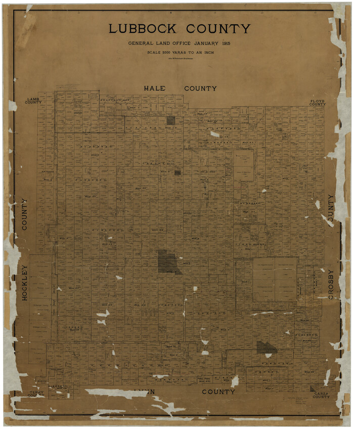
Print $40.00
- Digital $50.00
Lubbock County
1915
Size 49.0 x 40.6 inches
Map/Doc 895