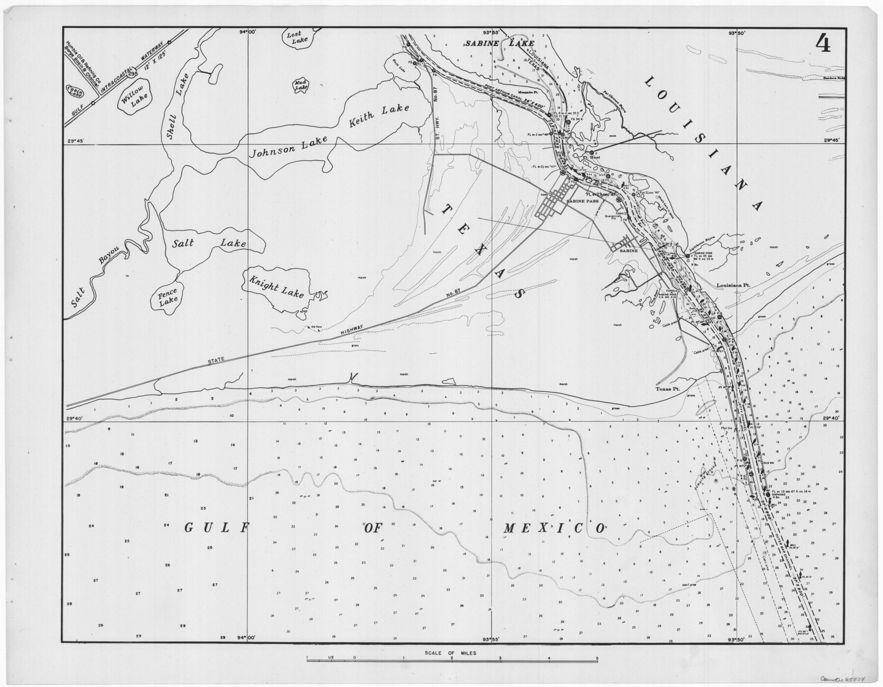
Navigation Maps of Gulf Intracoastal Waterway, Port Arthur to Brownsville, Texas
K-7-68
-
Map/Doc
65424
-
Collection
General Map Collection
-
Object Dates
1951 (Creation Date)
-
People and Organizations
Corps of Engineers (Publisher)
-
Counties
Jefferson
-
Subjects
Intracoastal Waterways
-
Height x Width
16.7 x 21.5 inches
42.4 x 54.6 cm
Part of: General Map Collection
Kerr County Working Sketch 26

Print $20.00
- Digital $50.00
Kerr County Working Sketch 26
1969
Size 31.2 x 32.1 inches
Map/Doc 70057
Flight Mission No. DQN-5K, Frame 81, Calhoun County

Print $20.00
- Digital $50.00
Flight Mission No. DQN-5K, Frame 81, Calhoun County
1953
Size 18.5 x 22.2 inches
Map/Doc 84414
Rio Grande, Madero Sheet

Print $20.00
- Digital $50.00
Rio Grande, Madero Sheet
1931
Size 33.0 x 38.5 inches
Map/Doc 65124
Coke County Rolled Sketch 2

Print $20.00
- Digital $50.00
Coke County Rolled Sketch 2
1947
Size 15.5 x 17.4 inches
Map/Doc 5504
Hill County Rolled Sketch 1

Print $20.00
- Digital $50.00
Hill County Rolled Sketch 1
1950
Size 13.1 x 41.0 inches
Map/Doc 6214
Cuadro Geografico y Estadistico

Print $20.00
- Digital $50.00
Cuadro Geografico y Estadistico
Size 23.1 x 30.9 inches
Map/Doc 96982
Jones County Rolled Sketch 2

Print $40.00
- Digital $50.00
Jones County Rolled Sketch 2
2009
Size 48.0 x 34.0 inches
Map/Doc 93320
Bell County Sketch File 23

Print $4.00
- Digital $50.00
Bell County Sketch File 23
1873
Size 8.2 x 12.8 inches
Map/Doc 14414


Howard County Sketch File 7

Print $20.00
- Digital $50.00
Howard County Sketch File 7
Size 21.7 x 13.8 inches
Map/Doc 11795
Limestone County Sketch File 10b

Print $22.00
- Digital $50.00
Limestone County Sketch File 10b
1875
Size 15.0 x 14.1 inches
Map/Doc 30175
You may also like
Blanco County Working Sketch 30

Print $20.00
- Digital $50.00
Blanco County Working Sketch 30
1971
Size 22.9 x 34.6 inches
Map/Doc 67390
Stephens County Working Sketch 6

Print $20.00
- Digital $50.00
Stephens County Working Sketch 6
1919
Size 13.1 x 22.0 inches
Map/Doc 63949
General Highway Map, Swisher County, Texas

Print $20.00
General Highway Map, Swisher County, Texas
1961
Size 18.3 x 25.0 inches
Map/Doc 79663
Galveston County Rolled Sketch 39

Print $20.00
- Digital $50.00
Galveston County Rolled Sketch 39
Size 18.1 x 21.5 inches
Map/Doc 45207
Matagorda County Working Sketch Graphic Index, Sheet 2 (Sketches 17 to Most Recent)

Print $40.00
- Digital $50.00
Matagorda County Working Sketch Graphic Index, Sheet 2 (Sketches 17 to Most Recent)
1920
Size 40.1 x 48.6 inches
Map/Doc 76634
Grimes County Working Sketch 2

Print $20.00
- Digital $50.00
Grimes County Working Sketch 2
1941
Size 13.2 x 20.9 inches
Map/Doc 63293
Oldham County

Print $20.00
- Digital $50.00
Oldham County
1888
Size 19.8 x 16.5 inches
Map/Doc 93019
Texas, Copano Bay, Port Bay

Print $40.00
- Digital $50.00
Texas, Copano Bay, Port Bay
1934
Size 32.9 x 48.8 inches
Map/Doc 73432
Donley County Boundary File 6

Print $6.00
- Digital $50.00
Donley County Boundary File 6
Size 5.7 x 8.7 inches
Map/Doc 52637
Old Miscellaneous File 30

Print $16.00
- Digital $50.00
Old Miscellaneous File 30
1845
Size 13.3 x 8.2 inches
Map/Doc 75740
Runnels County Working Sketch 2

Print $20.00
- Digital $50.00
Runnels County Working Sketch 2
Size 19.8 x 29.4 inches
Map/Doc 63598
Flight Mission No. BRA-16M, Frame 140, Jefferson County

Print $20.00
- Digital $50.00
Flight Mission No. BRA-16M, Frame 140, Jefferson County
1953
Size 18.6 x 22.2 inches
Map/Doc 85746