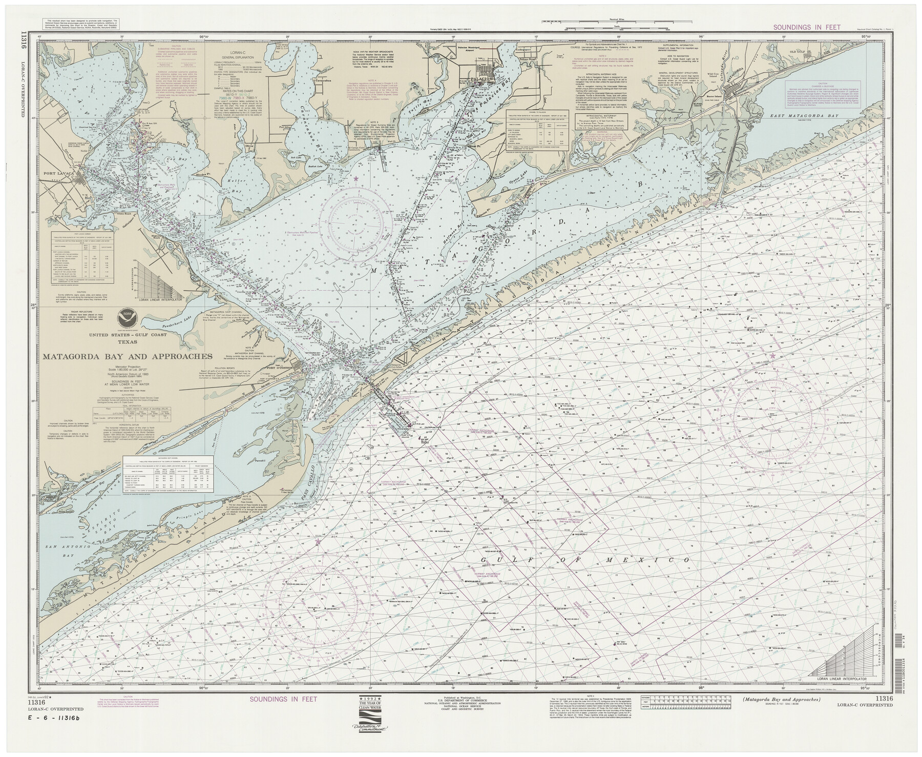
Matagorda Bay and Approaches
K-6-1284a
-
Map/Doc
73390
-
Collection
General Map Collection
-
Object Dates
6/6/1992 (Creation Date)
-
Counties
Matagorda Calhoun Victoria Jackson
-
Subjects
Nautical Charts
-
Height x Width
36.6 x 44.6 inches
93.0 x 113.3 cm
Part of: General Map Collection

Loving County Working Sketch 26

Print $40.00
- Digital $50.00
Loving County Working Sketch 26
2014
Size 33.3 x 48.0 inches
Map/Doc 93681
El Paso County

Print $40.00
- Digital $50.00
El Paso County
1881
Size 52.6 x 42.4 inches
Map/Doc 89058
Flight Mission No. DQN-1K, Frame 151, Calhoun County

Print $20.00
- Digital $50.00
Flight Mission No. DQN-1K, Frame 151, Calhoun County
1953
Size 18.6 x 22.3 inches
Map/Doc 84210
Rusk County Working Sketch 24

Print $20.00
- Digital $50.00
Rusk County Working Sketch 24
1949
Size 20.2 x 24.7 inches
Map/Doc 63660

[Surveys along the Little River]
![76048, [Surveys along the Little River], General Map Collection](https://historictexasmaps.com/wmedia_w700/maps/76048.tif.jpg)
Print $2.00
- Digital $50.00
[Surveys along the Little River]
1846
Size 10.6 x 7.8 inches
Map/Doc 76048
Harris County NRC Article 33.136 Sketch 3

Print $26.00
- Digital $50.00
Harris County NRC Article 33.136 Sketch 3
2001
Size 18.6 x 24.8 inches
Map/Doc 61597
Wichita County Rolled Sketch 20

Print $45.00
- Digital $50.00
Wichita County Rolled Sketch 20
Size 11.0 x 14.5 inches
Map/Doc 49546
Right of Way Map Fort Worth & Denver City Railroad through Hardeman County

Print $40.00
- Digital $50.00
Right of Way Map Fort Worth & Denver City Railroad through Hardeman County
1885
Size 23.8 x 121.2 inches
Map/Doc 64424
Zavala County Sketch File 15a

Print $6.00
- Digital $50.00
Zavala County Sketch File 15a
1886
Size 14.4 x 9.0 inches
Map/Doc 41321

You may also like
Crockett County Rolled Sketch P1

Print $82.00
- Digital $50.00
Crockett County Rolled Sketch P1
1927
Size 10.3 x 15.9 inches
Map/Doc 44220
Mason County Sketch File 11

Print $8.00
- Digital $50.00
Mason County Sketch File 11
1883
Size 13.5 x 8.6 inches
Map/Doc 30695
Concho County Working Sketch 14
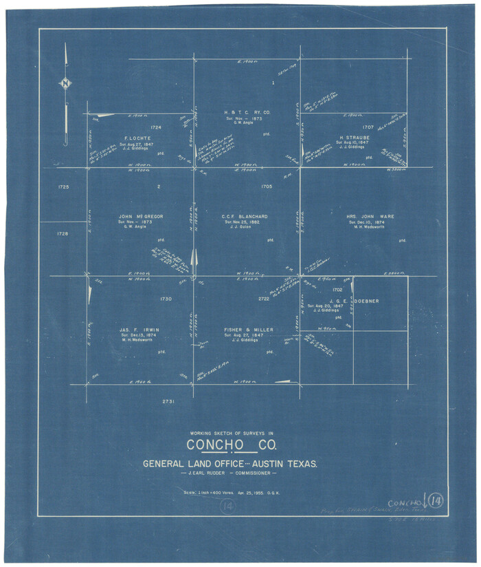
Print $20.00
- Digital $50.00
Concho County Working Sketch 14
1955
Size 24.7 x 21.0 inches
Map/Doc 68196
Nueces County Rolled Sketch 118

Print $20.00
- Digital $50.00
Nueces County Rolled Sketch 118
1988
Size 19.5 x 35.4 inches
Map/Doc 7150
Mitchell County Sketch File 8

Print $20.00
- Digital $50.00
Mitchell County Sketch File 8
1909
Size 26.9 x 20.9 inches
Map/Doc 12098
Upton County Rolled Sketch 43

Print $40.00
- Digital $50.00
Upton County Rolled Sketch 43
Size 27.1 x 54.2 inches
Map/Doc 10057
Zavala County Sketch File 37

Print $4.00
- Digital $50.00
Zavala County Sketch File 37
Size 12.9 x 8.1 inches
Map/Doc 41402
Kimble County Sketch File 20

Print $8.00
- Digital $50.00
Kimble County Sketch File 20
1892
Size 3.9 x 6.5 inches
Map/Doc 28957
Hudspeth County Sketch File 42

Print $12.00
- Digital $50.00
Hudspeth County Sketch File 42
1982
Size 14.2 x 8.7 inches
Map/Doc 27016
General Highway Map, Runnels County, Texas

Print $20.00
General Highway Map, Runnels County, Texas
1940
Size 24.7 x 18.3 inches
Map/Doc 79231

Chambers County NRC Article 33.136 Sketch 12

Print $30.00
- Digital $50.00
Chambers County NRC Article 33.136 Sketch 12
2020
Size 24.0 x 35.9 inches
Map/Doc 96441