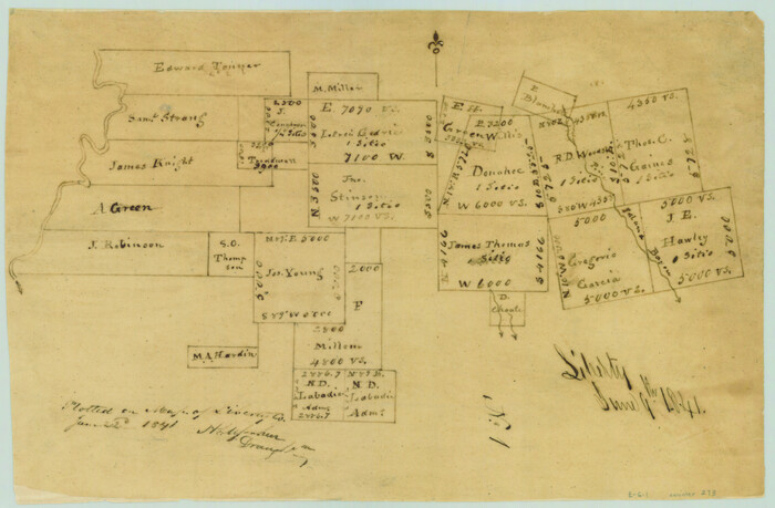
[Surveys in the Liberty District]
Print $2.00
- Digital $50.00
[Surveys in the Liberty District]
1841
Size: 7.0 x 10.7 inches
273
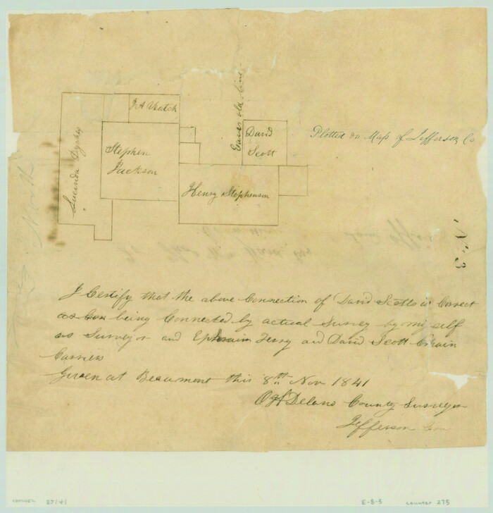
[Surveys in the Jefferson District]
Print $2.00
- Digital $50.00
[Surveys in the Jefferson District]
1841
Size: 8.3 x 8.0 inches
275
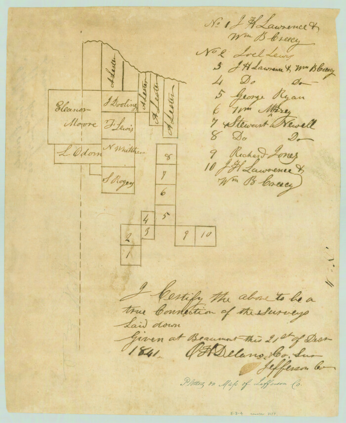
[Surveys in the Jefferson District]
Print $2.00
- Digital $50.00
[Surveys in the Jefferson District]
1841
Size: 9.8 x 8.0 inches
3177
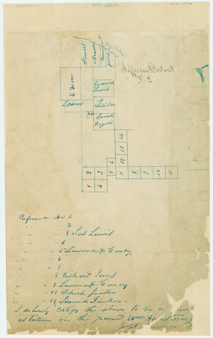
[Surveys in the Jefferson District]
Print $20.00
- Digital $50.00
[Surveys in the Jefferson District]
1841
Size: 14.6 x 21.2 inches
69726
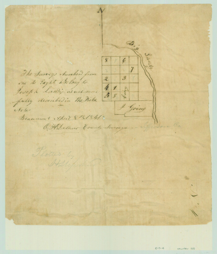
[Surveys in the Jefferson District along Big Sandy Creek]
Print $2.00
- Digital $50.00
[Surveys in the Jefferson District along Big Sandy Creek]
1841
Size: 9.5 x 8.1 inches
100
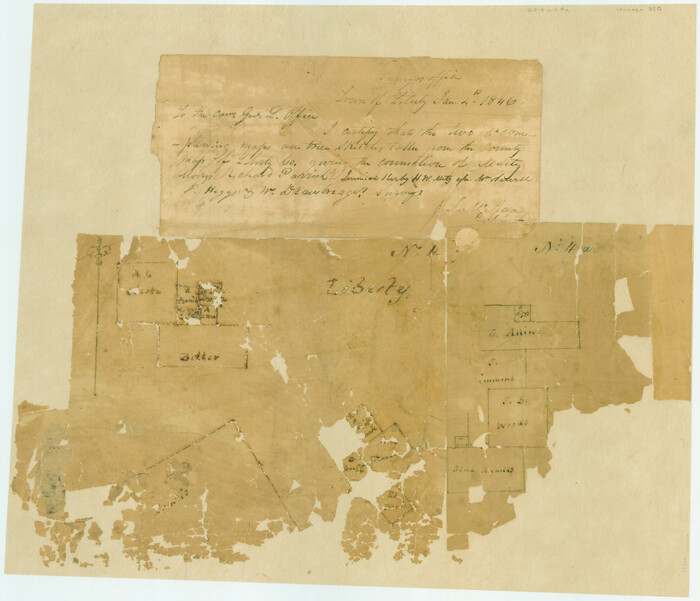
[Surveys along the Trinity River]
Print $20.00
- Digital $50.00
[Surveys along the Trinity River]
1846
Size: 12.6 x 14.7 inches
350
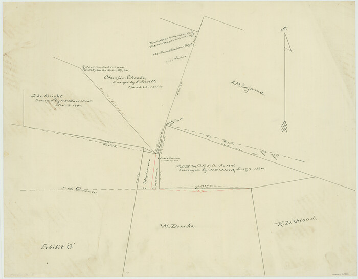
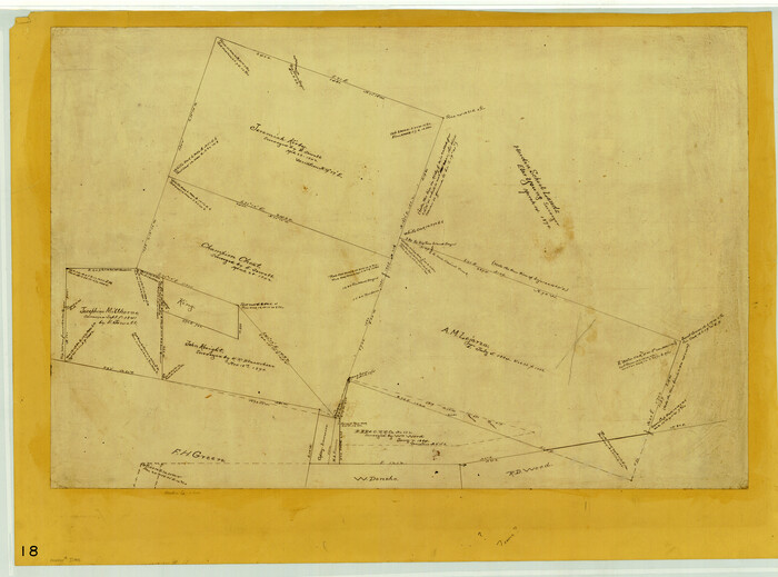
[Surveying Sketch of John Knight, Champion Choate, A.M. Lejarza, et al in Hardin County, Texas - Exhibit "G"]
Print $20.00
- Digital $50.00
[Surveying Sketch of John Knight, Champion Choate, A.M. Lejarza, et al in Hardin County, Texas - Exhibit "G"]
Size: 18.3 x 23.5 inches
75822
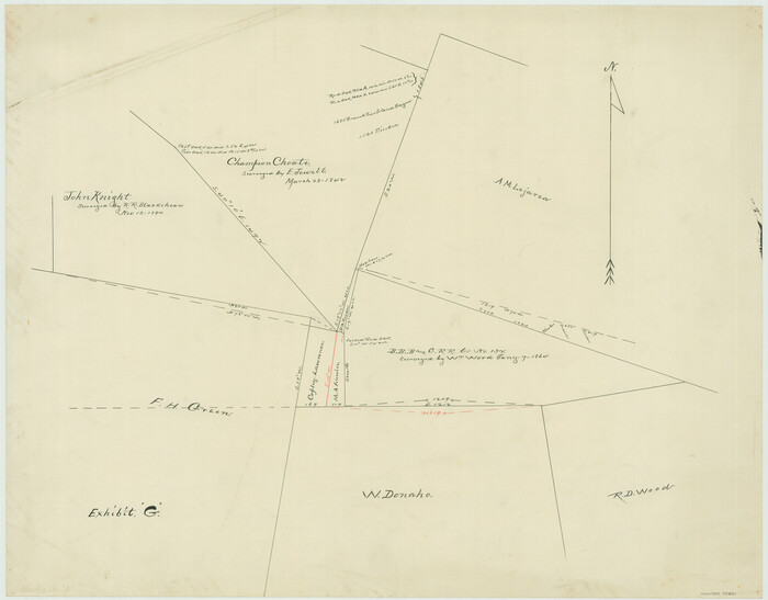
[Surveying Sketch of John Knight, Champion Choate, A. M. Lejarza, et al in Hardin County, Texas - Exhibit "G"]
Print $20.00
- Digital $50.00
[Surveying Sketch of John Knight, Champion Choate, A. M. Lejarza, et al in Hardin County, Texas - Exhibit "G"]
Size: 18.3 x 23.5 inches
75821
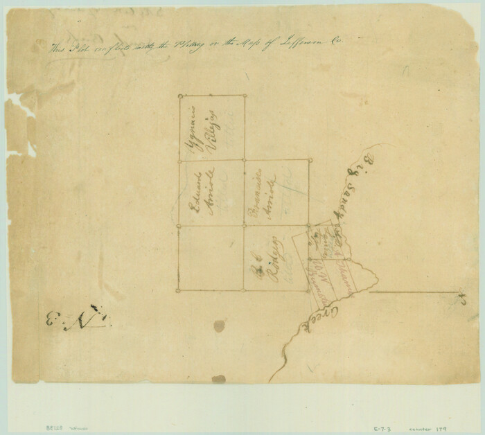
[Sketch of Surveys on Big Sandy Creek]
Print $2.00
- Digital $50.00
[Sketch of Surveys on Big Sandy Creek]
1841
Size: 8.2 x 9.2 inches
179
[Plat Showing Jeremiah Kirby, Champion Choat, A. M. Lejarza & Hardin Co. School Lands]
Print $20.00
- Digital $50.00
[Plat Showing Jeremiah Kirby, Champion Choat, A. M. Lejarza & Hardin Co. School Lands]
Size: 28.8 x 38.9 inches
5040
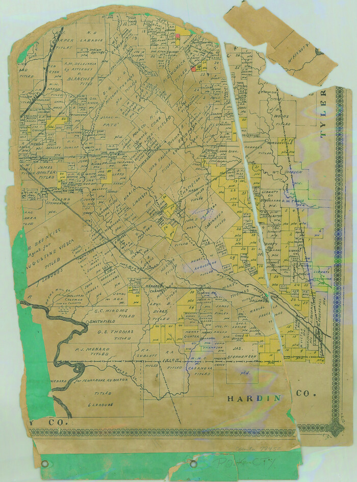
[Partial Map of Polk County, Texas]
Print $20.00
- Digital $50.00
[Partial Map of Polk County, Texas]
Size: 16.6 x 12.3 inches
78452
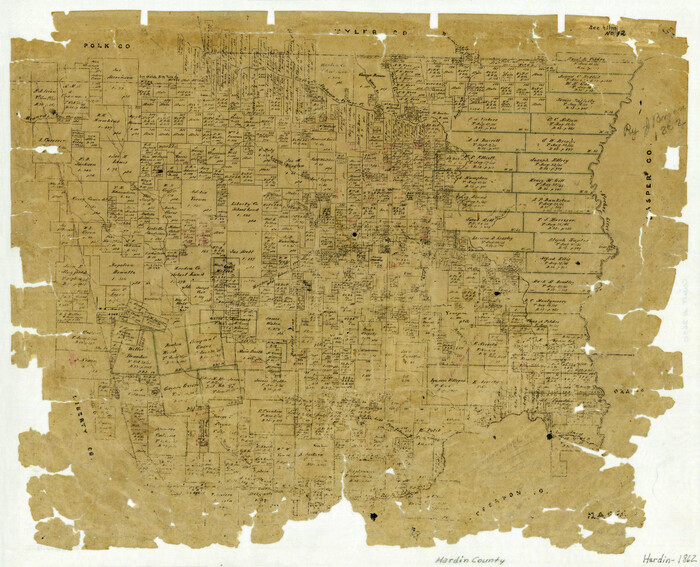
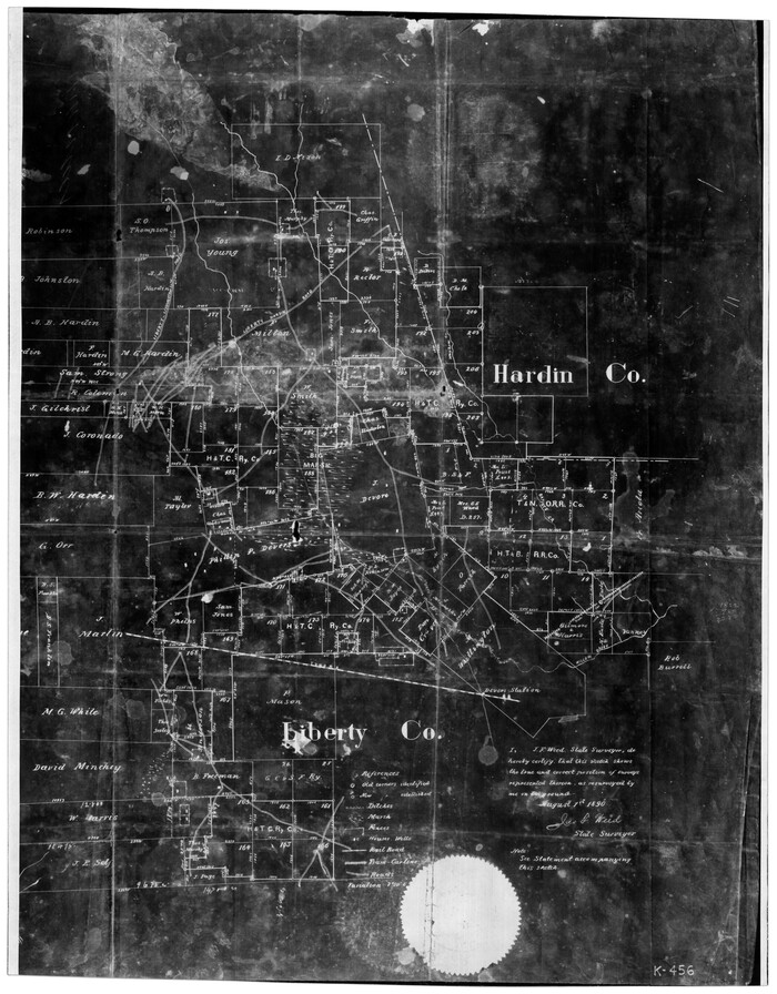
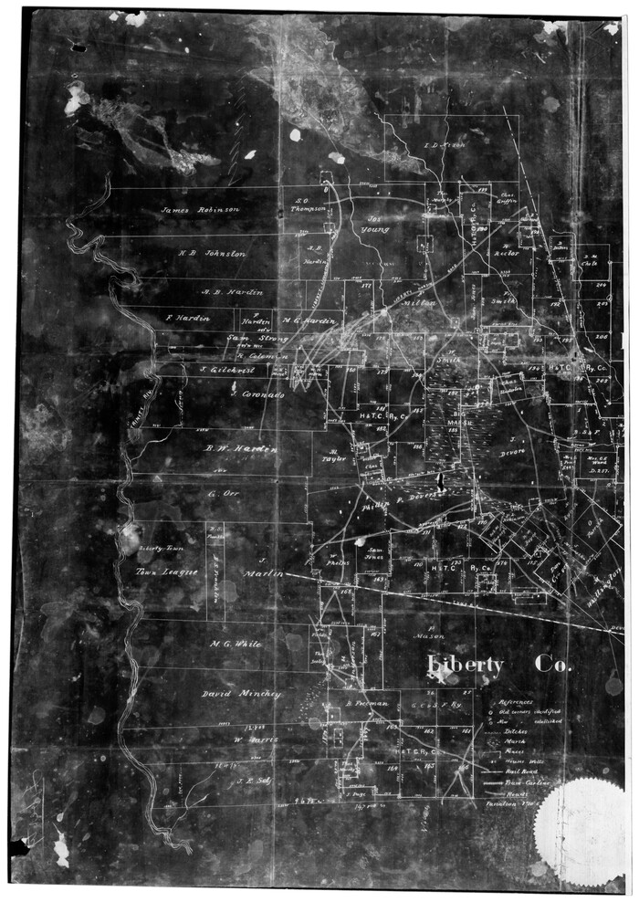
[Map of Hardin County]
Print $20.00
- Digital $50.00
[Map of Hardin County]
1862
Size: 18.0 x 22.0 inches
3630
[Liberty County, Texas]
Print $20.00
- Digital $50.00
[Liberty County, Texas]
1890
Size: 23.7 x 18.3 inches
2058
[Liberty County, Texas]
Print $20.00
- Digital $50.00
[Liberty County, Texas]
1890
Size: 24.2 x 16.9 inches
60297
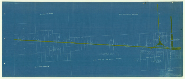
[Beaumont, Sour Lake and Western Ry. Right of Way and Alignment - Frisco]
Print $20.00
- Digital $50.00
[Beaumont, Sour Lake and Western Ry. Right of Way and Alignment - Frisco]
1910
Size: 19.8 x 45.9 inches
64111
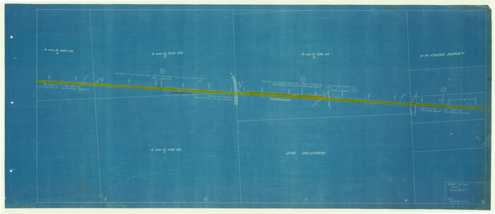
[Beaumont, Sour Lake and Western Ry. Right of Way and Alignment - Frisco]
Print $20.00
- Digital $50.00
[Beaumont, Sour Lake and Western Ry. Right of Way and Alignment - Frisco]
1910
Size: 20.3 x 46.0 inches
64112
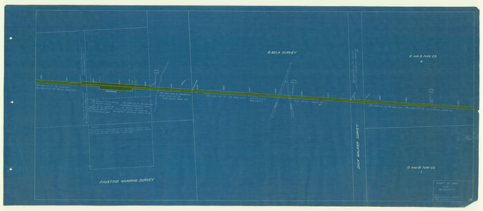
[Beaumont, Sour Lake and Western Ry. Right of Way and Alignment - Frisco]
Print $20.00
- Digital $50.00
[Beaumont, Sour Lake and Western Ry. Right of Way and Alignment - Frisco]
1910
Size: 19.9 x 46.3 inches
64113
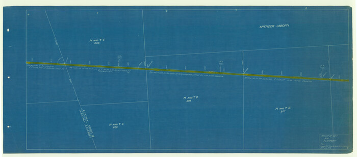
[Beaumont, Sour Lake and Western Ry. Right of Way and Alignment - Frisco]
Print $20.00
- Digital $50.00
[Beaumont, Sour Lake and Western Ry. Right of Way and Alignment - Frisco]
1910
Size: 19.9 x 46.0 inches
64114
[Beaumont, Sour Lake and Western Ry. Right of Way and Alignment - Frisco]
Print $20.00
- Digital $50.00
[Beaumont, Sour Lake and Western Ry. Right of Way and Alignment - Frisco]
1910
Size: 20.1 x 45.9 inches
64115
[Beaumont, Sour Lake and Western Ry. Right of Way and Alignment - Frisco]
Print $20.00
- Digital $50.00
[Beaumont, Sour Lake and Western Ry. Right of Way and Alignment - Frisco]
1910
Size: 20.3 x 46.1 inches
64116
Tyler County Working Sketch 24

Print $20.00
- Digital $50.00
Tyler County Working Sketch 24
1989
Size: 34.8 x 40.6 inches
69494
Tyler County Sketch File 5

Print $20.00
- Digital $50.00
Tyler County Sketch File 5
1854
Size: 13.2 x 17.4 inches
12497
Tyler County Sketch File 3

Print $10.00
- Digital $50.00
Tyler County Sketch File 3
1855
Size: 8.5 x 8.0 inches
38622
Tyler County Sketch File 21

Print $4.00
- Digital $50.00
Tyler County Sketch File 21
1906
Size: 10.9 x 9.1 inches
38677
Tyler County Sketch File 1b

Print $8.00
- Digital $50.00
Tyler County Sketch File 1b
1900
Size: 7.5 x 3.2 inches
38611
Tyler County Rolled Sketch 2

Print $20.00
- Digital $50.00
Tyler County Rolled Sketch 2
1944
Size: 29.6 x 17.4 inches
8056
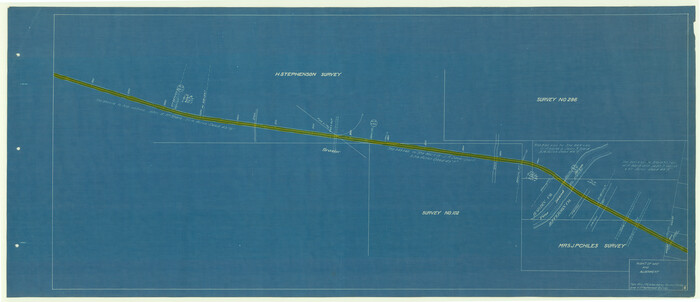
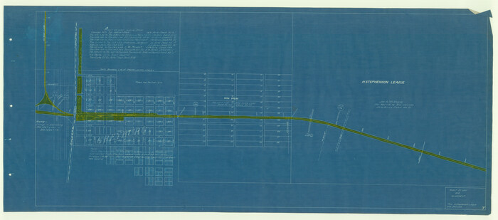
T. & N. O. R.R. Jefferson Co. North

Print $20.00
- Digital $50.00
T. & N. O. R.R. Jefferson Co. North
1917
Size: 13.4 x 33.5 inches
64058
Sketch X, Hardin County

Print $20.00
- Digital $50.00
Sketch X, Hardin County
1904
Size: 26.3 x 38.1 inches
75823
Report of Construction re: MA 46948, H. C. Henson

Print $2.00
- Digital $50.00
Report of Construction re: MA 46948, H. C. Henson
1954
Size: 11.1 x 8.9 inches
62571
Polk County Working Sketch 6

Print $20.00
- Digital $50.00
Polk County Working Sketch 6
1933
Size: 22.8 x 32.7 inches
71621
[Surveys in the Liberty District]
Print $2.00
- Digital $50.00
[Surveys in the Liberty District]
1841
-
Size
7.0 x 10.7 inches
-
Map/Doc
273
-
Creation Date
1841
[Surveys in the Jefferson District]
Print $2.00
- Digital $50.00
[Surveys in the Jefferson District]
1841
-
Size
8.3 x 8.0 inches
-
Map/Doc
275
-
Creation Date
1841
[Surveys in the Jefferson District]
Print $2.00
- Digital $50.00
[Surveys in the Jefferson District]
1841
-
Size
9.8 x 8.0 inches
-
Map/Doc
3177
-
Creation Date
1841
[Surveys in the Jefferson District]
Print $20.00
- Digital $50.00
[Surveys in the Jefferson District]
1841
-
Size
14.6 x 21.2 inches
-
Map/Doc
69726
-
Creation Date
1841
[Surveys in the Jefferson District along Big Sandy Creek]
Print $2.00
- Digital $50.00
[Surveys in the Jefferson District along Big Sandy Creek]
1841
-
Size
9.5 x 8.1 inches
-
Map/Doc
100
-
Creation Date
1841
[Surveys along the Trinity River]
Print $20.00
- Digital $50.00
[Surveys along the Trinity River]
1846
-
Size
12.6 x 14.7 inches
-
Map/Doc
350
-
Creation Date
1846
[Surveying Sketch of John Knight, Champion Choate, A.M. Lejarza, et al in Hardin County, Texas - Exhibit "G"]
Print $20.00
- Digital $50.00
[Surveying Sketch of John Knight, Champion Choate, A.M. Lejarza, et al in Hardin County, Texas - Exhibit "G"]
-
Size
18.3 x 23.5 inches
-
Map/Doc
75822
[Surveying Sketch of John Knight, Champion Choate, A. M. Lejarza, et al in Hardin County, Texas - Exhibit "G"]
Print $20.00
- Digital $50.00
[Surveying Sketch of John Knight, Champion Choate, A. M. Lejarza, et al in Hardin County, Texas - Exhibit "G"]
-
Size
18.3 x 23.5 inches
-
Map/Doc
75821
[Sketch of Surveys on Big Sandy Creek]
Print $2.00
- Digital $50.00
[Sketch of Surveys on Big Sandy Creek]
1841
-
Size
8.2 x 9.2 inches
-
Map/Doc
179
-
Creation Date
1841
[Plat Showing Jeremiah Kirby, Champion Choat, A. M. Lejarza & Hardin Co. School Lands]
Print $20.00
- Digital $50.00
[Plat Showing Jeremiah Kirby, Champion Choat, A. M. Lejarza & Hardin Co. School Lands]
-
Size
28.8 x 38.9 inches
-
Map/Doc
5040
[Partial Map of Polk County, Texas]
Print $20.00
- Digital $50.00
[Partial Map of Polk County, Texas]
-
Size
16.6 x 12.3 inches
-
Map/Doc
78452
[Map of Hardin County]
Print $20.00
- Digital $50.00
[Map of Hardin County]
1862
-
Size
18.0 x 22.0 inches
-
Map/Doc
3630
-
Creation Date
1862
[Liberty County, Texas]
Print $20.00
- Digital $50.00
[Liberty County, Texas]
1890
-
Size
23.7 x 18.3 inches
-
Map/Doc
2058
-
Creation Date
1890
[Liberty County, Texas]
Print $20.00
- Digital $50.00
[Liberty County, Texas]
1890
-
Size
24.2 x 16.9 inches
-
Map/Doc
60297
-
Creation Date
1890
[Beaumont, Sour Lake and Western Ry. Right of Way and Alignment - Frisco]
Print $20.00
- Digital $50.00
[Beaumont, Sour Lake and Western Ry. Right of Way and Alignment - Frisco]
1910
-
Size
19.8 x 45.9 inches
-
Map/Doc
64111
-
Creation Date
1910
[Beaumont, Sour Lake and Western Ry. Right of Way and Alignment - Frisco]
Print $20.00
- Digital $50.00
[Beaumont, Sour Lake and Western Ry. Right of Way and Alignment - Frisco]
1910
-
Size
20.3 x 46.0 inches
-
Map/Doc
64112
-
Creation Date
1910
[Beaumont, Sour Lake and Western Ry. Right of Way and Alignment - Frisco]
Print $20.00
- Digital $50.00
[Beaumont, Sour Lake and Western Ry. Right of Way and Alignment - Frisco]
1910
-
Size
19.9 x 46.3 inches
-
Map/Doc
64113
-
Creation Date
1910
[Beaumont, Sour Lake and Western Ry. Right of Way and Alignment - Frisco]
Print $20.00
- Digital $50.00
[Beaumont, Sour Lake and Western Ry. Right of Way and Alignment - Frisco]
1910
-
Size
19.9 x 46.0 inches
-
Map/Doc
64114
-
Creation Date
1910
[Beaumont, Sour Lake and Western Ry. Right of Way and Alignment - Frisco]
Print $20.00
- Digital $50.00
[Beaumont, Sour Lake and Western Ry. Right of Way and Alignment - Frisco]
1910
-
Size
20.1 x 45.9 inches
-
Map/Doc
64115
-
Creation Date
1910
[Beaumont, Sour Lake and Western Ry. Right of Way and Alignment - Frisco]
Print $20.00
- Digital $50.00
[Beaumont, Sour Lake and Western Ry. Right of Way and Alignment - Frisco]
1910
-
Size
20.3 x 46.1 inches
-
Map/Doc
64116
-
Creation Date
1910
Tyler County Working Sketch 24
Print $20.00
- Digital $50.00
Tyler County Working Sketch 24
1989
-
Size
34.8 x 40.6 inches
-
Map/Doc
69494
-
Creation Date
1989
Tyler County Sketch File 5
Print $20.00
- Digital $50.00
Tyler County Sketch File 5
1854
-
Size
13.2 x 17.4 inches
-
Map/Doc
12497
-
Creation Date
1854
Tyler County Sketch File 3
Print $10.00
- Digital $50.00
Tyler County Sketch File 3
1855
-
Size
8.5 x 8.0 inches
-
Map/Doc
38622
-
Creation Date
1855
Tyler County Sketch File 21
Print $4.00
- Digital $50.00
Tyler County Sketch File 21
1906
-
Size
10.9 x 9.1 inches
-
Map/Doc
38677
-
Creation Date
1906
Tyler County Sketch File 1b
Print $8.00
- Digital $50.00
Tyler County Sketch File 1b
1900
-
Size
7.5 x 3.2 inches
-
Map/Doc
38611
-
Creation Date
1900
Tyler County Rolled Sketch 2
Print $20.00
- Digital $50.00
Tyler County Rolled Sketch 2
1944
-
Size
29.6 x 17.4 inches
-
Map/Doc
8056
-
Creation Date
1944
T. & N. O. R.R. Jefferson Co. North
Print $20.00
- Digital $50.00
T. & N. O. R.R. Jefferson Co. North
1917
-
Size
13.4 x 33.5 inches
-
Map/Doc
64058
-
Creation Date
1917
Sketch X, Hardin County
Print $20.00
- Digital $50.00
Sketch X, Hardin County
1904
-
Size
26.3 x 38.1 inches
-
Map/Doc
75823
-
Creation Date
1904
Report of Construction re: MA 46948, H. C. Henson
Print $2.00
- Digital $50.00
Report of Construction re: MA 46948, H. C. Henson
1954
-
Size
11.1 x 8.9 inches
-
Map/Doc
62571
-
Creation Date
1954
Polk County Working Sketch 6
Print $20.00
- Digital $50.00
Polk County Working Sketch 6
1933
-
Size
22.8 x 32.7 inches
-
Map/Doc
71621
-
Creation Date
1933