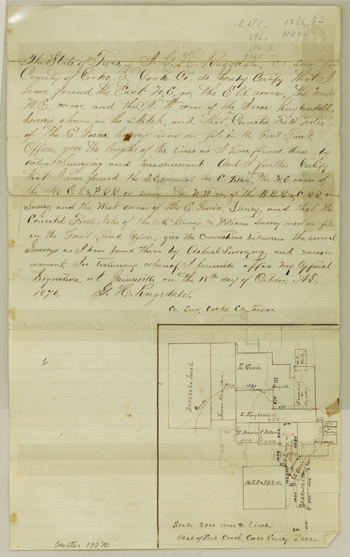
Cooke County Sketch File 23
[Sketch of surveys on Fish Creek]
-
Map/Doc
19270
-
Collection
General Map Collection
-
Object Dates
1870/10/18 (Creation Date)
1870/11/15 (File Date)
-
People and Organizations
G.H. Ragsdale (Surveyor/Engineer)
-
Counties
Cooke
-
Subjects
Surveying Sketch File
-
Height x Width
12.7 x 8.0 inches
32.3 x 20.3 cm
-
Medium
paper, manuscript
-
Scale
1" = 2000 varas
-
Features
South Fish Creek
Marysville
Part of: General Map Collection
Pecos County Sketch File 49c

Print $10.00
- Digital $50.00
Pecos County Sketch File 49c
Size 5.9 x 8.7 inches
Map/Doc 33768
Pecos County Sketch File 30

Print $20.00
- Digital $50.00
Pecos County Sketch File 30
Size 28.9 x 22.0 inches
Map/Doc 12172
Waller County Sketch File 1

Print $14.00
- Digital $50.00
Waller County Sketch File 1
Size 8.1 x 6.9 inches
Map/Doc 39563
Schleicher County Working Sketch 15

Print $20.00
- Digital $50.00
Schleicher County Working Sketch 15
1940
Size 30.1 x 33.6 inches
Map/Doc 63817
Post Route Map of Texas (Inset 1: Dallas-Fort Worth Area; Inset 2: Texas Panhandle)

Print $40.00
- Digital $50.00
Post Route Map of Texas (Inset 1: Dallas-Fort Worth Area; Inset 2: Texas Panhandle)
1939
Size 56.9 x 39.3 inches
Map/Doc 93668
Jeff Davis County Texas

Print $20.00
- Digital $50.00
Jeff Davis County Texas
Size 16.1 x 21.1 inches
Map/Doc 4572
[Surveys in Milam's Colony between the Colorado River and northwest of the San Antonio Road]
![29, [Surveys in Milam's Colony between the Colorado River and northwest of the San Antonio Road], General Map Collection](https://historictexasmaps.com/wmedia_w700/maps/29-1.tif.jpg)
Print $20.00
- Digital $50.00
[Surveys in Milam's Colony between the Colorado River and northwest of the San Antonio Road]
Size 22.0 x 27.4 inches
Map/Doc 29
Menard County Boundary File 12

Print $66.00
- Digital $50.00
Menard County Boundary File 12
Size 8.7 x 8.7 inches
Map/Doc 57099
Presidio County Sketch File R

Print $18.00
- Digital $50.00
Presidio County Sketch File R
Size 10.3 x 8.4 inches
Map/Doc 34590
Map of Brassos [sic] & Bosque Surveys
![146, Map of Brassos [sic] & Bosque Surveys, General Map Collection](https://historictexasmaps.com/wmedia_w700/maps/146.tif.jpg)
Print $20.00
- Digital $50.00
Map of Brassos [sic] & Bosque Surveys
1841
Size 27.7 x 18.9 inches
Map/Doc 146
Lavaca County Rolled Sketch 7

Print $20.00
- Digital $50.00
Lavaca County Rolled Sketch 7
Size 37.4 x 32.7 inches
Map/Doc 10291
Travels to the source of the Missouri River and across the American Continent to the Pacific Ocean - Vol. 3

Travels to the source of the Missouri River and across the American Continent to the Pacific Ocean - Vol. 3
1815
Map/Doc 97414
You may also like
Howard County

Print $20.00
- Digital $50.00
Howard County
1922
Size 41.3 x 35.2 inches
Map/Doc 73185
Presidio County Sketch File 68

Print $4.00
- Digital $50.00
Presidio County Sketch File 68
1941
Size 11.2 x 8.8 inches
Map/Doc 34662
Presidio County Sketch File 84

Print $20.00
- Digital $50.00
Presidio County Sketch File 84
1949
Size 15.2 x 37.2 inches
Map/Doc 11723

Milam County Working Sketch 3

Print $20.00
- Digital $50.00
Milam County Working Sketch 3
Size 29.0 x 38.4 inches
Map/Doc 71018

Map Showing Position of Surveys Represented Hereon

Print $40.00
- Digital $50.00
Map Showing Position of Surveys Represented Hereon
Size 38.9 x 57.2 inches
Map/Doc 75809
Karnes County Working Sketch 15

Print $20.00
- Digital $50.00
Karnes County Working Sketch 15
1987
Size 36.0 x 41.1 inches
Map/Doc 66663
Texas Panhandle East Boundary Line

Print $40.00
- Digital $50.00
Texas Panhandle East Boundary Line
1898
Size 9.2 x 64.9 inches
Map/Doc 1716
Pecos County Rolled Sketch 93

Print $40.00
- Digital $50.00
Pecos County Rolled Sketch 93
Size 50.3 x 42.8 inches
Map/Doc 9711
Hardin County Working Sketch 16

Print $20.00
- Digital $50.00
Hardin County Working Sketch 16
1940
Size 18.1 x 23.2 inches
Map/Doc 63414
Sulphur River, Terry Lake Sheet

Print $20.00
- Digital $50.00
Sulphur River, Terry Lake Sheet
1919
Size 15.7 x 18.3 inches
Map/Doc 78337