Pecos County Rolled Sketch DK1
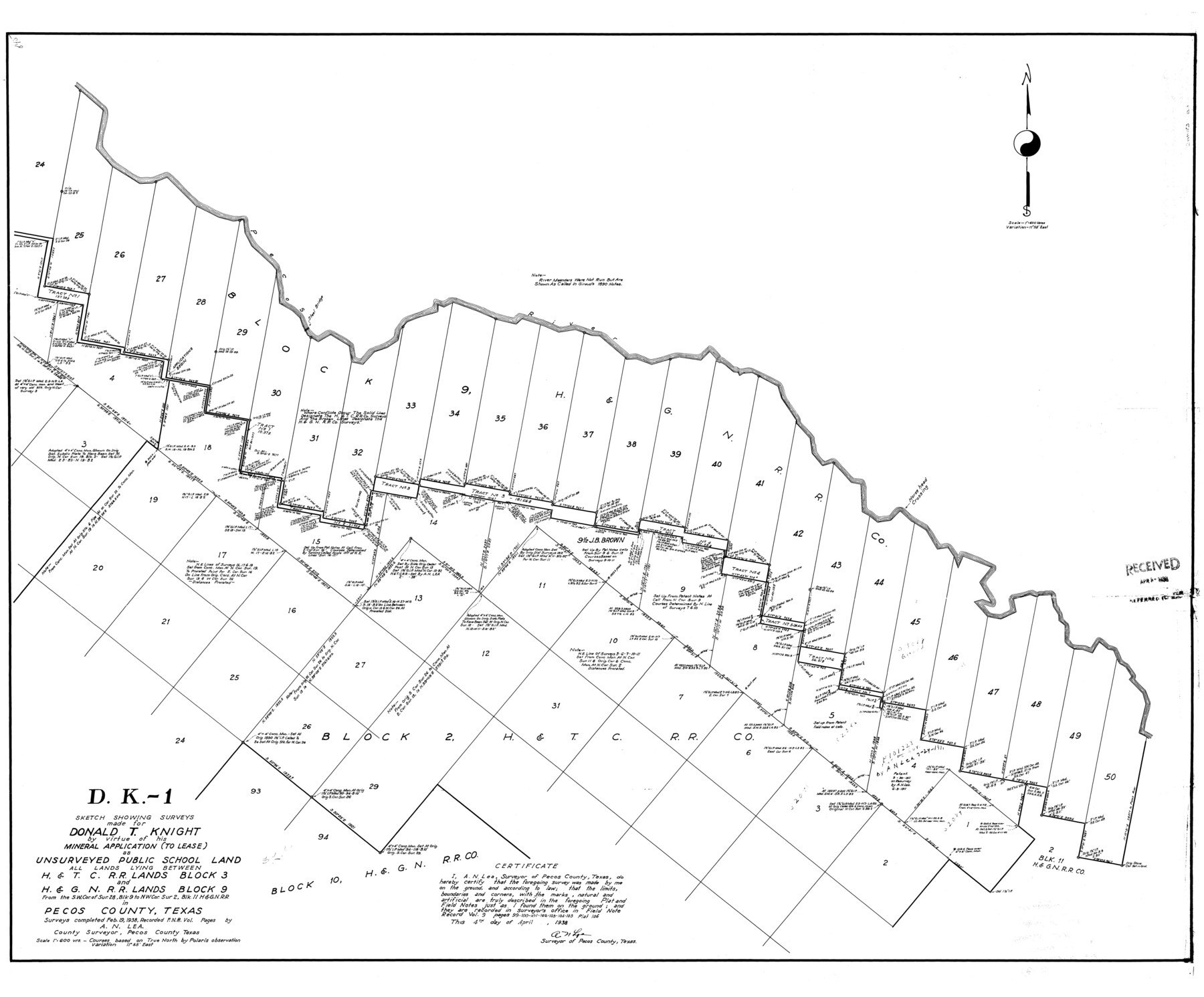
Sketch showing surveys made for Donald T. Knight by virtue of his Mineral Application (to lease) as unsurveyed Public School Land all lands lying between H. & T. C. R.R. Lands Block 3 and H. & G. N. R.R. Lands Block 9
-
Map/Doc
9713
-
Collection
General Map Collection
-
Object Dates
4/4/1938 (Creation Date)
4/5/1938 (File Date)
2/19/1938 (Revision Date)
-
People and Organizations
A.N. Lea (Surveyor/Engineer)
-
Counties
Pecos
-
Subjects
Surveying Rolled Sketch
-
Height x Width
36.2 x 43.7 inches
92.0 x 111.0 cm
-
Scale
1" = 600 varas
Part of: General Map Collection
Brazos River, Millican Sheet

Print $6.00
- Digital $50.00
Brazos River, Millican Sheet
1936
Size 30.1 x 31.6 inches
Map/Doc 65278
Map of Texas compiled from surveys recorded in the Land Office of Texas and other official surveys

Print $20.00
- Digital $50.00
Map of Texas compiled from surveys recorded in the Land Office of Texas and other official surveys
1841
Size 24.6 x 24.2 inches
Map/Doc 96435
Ector County Working Sketch 28

Print $40.00
- Digital $50.00
Ector County Working Sketch 28
1971
Size 43.3 x 61.6 inches
Map/Doc 68871
Flight Mission No. DCL-6C, Frame 5, Kenedy County

Print $20.00
- Digital $50.00
Flight Mission No. DCL-6C, Frame 5, Kenedy County
1943
Size 18.4 x 22.4 inches
Map/Doc 85865
Jasper County Working Sketch 28

Print $20.00
- Digital $50.00
Jasper County Working Sketch 28
1955
Size 22.6 x 15.6 inches
Map/Doc 66490
Val Verde County Rolled Sketch 69A

Print $40.00
- Digital $50.00
Val Verde County Rolled Sketch 69A
1942
Size 11.0 x 139.1 inches
Map/Doc 10086
Upshur County Working Sketch 16, revised

Print $20.00
- Digital $50.00
Upshur County Working Sketch 16, revised
1997
Size 42.9 x 37.2 inches
Map/Doc 69574
Index for Texas Railroad ROW & track maps available on microfilm at THD & Archives and Records

Print $2.00
- Digital $50.00
Index for Texas Railroad ROW & track maps available on microfilm at THD & Archives and Records
1977
Size 11.1 x 8.9 inches
Map/Doc 60755
Val Verde County Working Sketch 21

Print $20.00
- Digital $50.00
Val Verde County Working Sketch 21
1929
Size 15.2 x 30.0 inches
Map/Doc 72156
[William Steele Survey near Copano Bay]
![60284, [William Steele Survey near Copano Bay], General Map Collection](https://historictexasmaps.com/wmedia_w700/maps/60284-1.tif.jpg)
Print $3.00
- Digital $50.00
[William Steele Survey near Copano Bay]
1927
Size 15.5 x 9.5 inches
Map/Doc 60284
Anderson County Sketch File 4

Print $6.00
- Digital $50.00
Anderson County Sketch File 4
Size 8.7 x 6.4 inches
Map/Doc 12743
Packery Channel

Print $20.00
- Digital $50.00
Packery Channel
1958
Size 29.5 x 37.5 inches
Map/Doc 2992
You may also like
Terrell County Working Sketch Graphic index - sheet B

Print $20.00
- Digital $50.00
Terrell County Working Sketch Graphic index - sheet B
1931
Size 47.7 x 39.6 inches
Map/Doc 76711
Lynn County Boundary File 1

Print $10.00
- Digital $50.00
Lynn County Boundary File 1
Size 14.2 x 8.7 inches
Map/Doc 56617
Crockett County Sketch File 43

Print $20.00
- Digital $50.00
Crockett County Sketch File 43
1880
Size 17.9 x 23.8 inches
Map/Doc 11223
The Republic County of Austin. January 10, 1839

Print $20.00
The Republic County of Austin. January 10, 1839
2020
Size 7.0 x 22.0 inches
Map/Doc 96083
San Jacinto River, Proposed Dam Site/Huntsville State Park

Print $6.00
- Digital $50.00
San Jacinto River, Proposed Dam Site/Huntsville State Park
1937
Size 30.2 x 26.6 inches
Map/Doc 65151
Map of the Surveyed Part of Young District

Print $40.00
- Digital $50.00
Map of the Surveyed Part of Young District
1860
Size 56.2 x 54.7 inches
Map/Doc 1986
[Sketch for Mineral Application 1112 - Colorado River, H. E. Chambers]
![65639, [Sketch for Mineral Application 1112 - Colorado River, H. E. Chambers], General Map Collection](https://historictexasmaps.com/wmedia_w700/maps/65639.tif.jpg)
Print $20.00
- Digital $50.00
[Sketch for Mineral Application 1112 - Colorado River, H. E. Chambers]
1918
Size 17.3 x 28.3 inches
Map/Doc 65639
America's Fun-Tier: Texas 1965 Official Highway Travel Map

Digital $50.00
America's Fun-Tier: Texas 1965 Official Highway Travel Map
Size 28.2 x 36.4 inches
Map/Doc 94325
San Augustine County School Land for sale by Lubbock Irrigation Company

Print $20.00
- Digital $50.00
San Augustine County School Land for sale by Lubbock Irrigation Company
Size 24.0 x 25.2 inches
Map/Doc 92874
Galveston County NRC Article 33.136 Sketch 66

Print $42.00
- Digital $50.00
Galveston County NRC Article 33.136 Sketch 66
2012
Size 23.0 x 34.8 inches
Map/Doc 95000
In the Supreme Court of the United States The State of Oklahoma, Complainant vs. The State of Texas, Defendant, The United States of America, Intervener - 1921

Print $40.00
- Digital $50.00
In the Supreme Court of the United States The State of Oklahoma, Complainant vs. The State of Texas, Defendant, The United States of America, Intervener - 1921
1921
Size 25.7 x 61.1 inches
Map/Doc 75127
Montgomery County Sketch File 13

Print $40.00
- Digital $50.00
Montgomery County Sketch File 13
1900
Size 17.8 x 14.8 inches
Map/Doc 31803