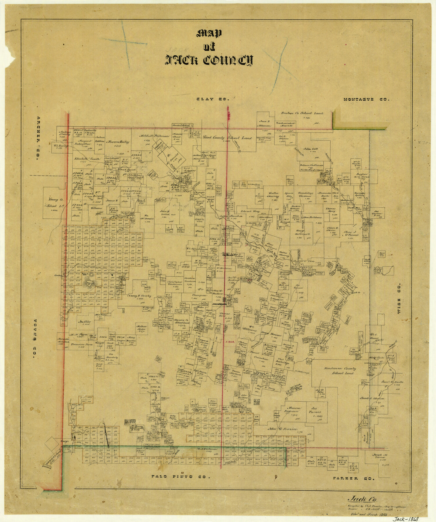
Map of Jack County
-
Map/Doc
3701
-
Collection
General Map Collection
-
Object Dates
3/1868 (Creation Date)
-
People and Organizations
Chas. W. Pressler (Compiler)
F.H. Arlitt (Draftsman)
-
Counties
Jack
-
Subjects
County
-
Height x Width
23.8 x 19.8 inches
60.5 x 50.3 cm
-
Features
Pecan Creek
North Creek
Jacksboro
Lost Creek
Been's [sic] Creek
Jasper Creek
Hog Creek
Gentry's Creek
Willow Creek
Rock Creek
Carroll's Creek
Brazos River
Salt Fork
West Fork
East Fork of Keechi Creek
Boon's Creek
Keechi Creek
Franks Creek
Lodge Creek
Muscle Creek
Contrary Creek
Russell's Creek
Twitty Creek
Martins Creek
Bennet's Creek
Cundiff's Creek
School Creek
West Fork of Trinity River
Crooked Creek
West Fork of Keechi Creek
Lost Valley Creek
Lyon's Creek
Postoak Hill
Fishpond Mountain
Part of: General Map Collection
Sterling County Sketch File A

Print $20.00
- Digital $50.00
Sterling County Sketch File A
1906
Size 18.2 x 26.0 inches
Map/Doc 12362
Gonzales County

Print $40.00
- Digital $50.00
Gonzales County
1920
Size 48.4 x 44.2 inches
Map/Doc 4706
Navigation Maps of Gulf Intracoastal Waterway, Port Arthur to Brownsville, Texas

Print $4.00
- Digital $50.00
Navigation Maps of Gulf Intracoastal Waterway, Port Arthur to Brownsville, Texas
1951
Size 16.7 x 21.4 inches
Map/Doc 65446
Flight Mission No. DQN-5K, Frame 31, Calhoun County

Print $20.00
- Digital $50.00
Flight Mission No. DQN-5K, Frame 31, Calhoun County
1953
Size 18.5 x 22.1 inches
Map/Doc 84382
Wheeler County Sketch File A

Print $20.00
- Digital $50.00
Wheeler County Sketch File A
1888
Size 15.5 x 31.8 inches
Map/Doc 12677
Donley County Rolled Sketch 3A

Print $20.00
- Digital $50.00
Donley County Rolled Sketch 3A
1946
Size 15.2 x 22.6 inches
Map/Doc 5730
Hunt County Boundary File 10

Print $14.00
- Digital $50.00
Hunt County Boundary File 10
Size 9.2 x 14.9 inches
Map/Doc 55255
Navarro County Working Sketch 1a

Print $20.00
- Digital $50.00
Navarro County Working Sketch 1a
1888
Size 32.5 x 44.6 inches
Map/Doc 71229
Presidio County Working Sketch 129

Print $20.00
- Digital $50.00
Presidio County Working Sketch 129
1988
Size 24.0 x 24.7 inches
Map/Doc 71807
Nueces County NRC Article 33.136 Sketch 16

Print $68.00
- Digital $50.00
Nueces County NRC Article 33.136 Sketch 16
2012
Size 22.0 x 17.0 inches
Map/Doc 94804
Flight Mission No. DQN-2K, Frame 136, Calhoun County

Print $20.00
- Digital $50.00
Flight Mission No. DQN-2K, Frame 136, Calhoun County
1953
Size 18.5 x 15.8 inches
Map/Doc 84305
Coast Chart No. 209 - Aransas Pass, Aransas and Copano Bays, Texas

Print $20.00
- Digital $50.00
Coast Chart No. 209 - Aransas Pass, Aransas and Copano Bays, Texas
1906
Size 40.2 x 33.8 inches
Map/Doc 73430
You may also like
Map of Terry County

Print $20.00
- Digital $50.00
Map of Terry County
1893
Size 27.4 x 23.3 inches
Map/Doc 4076
Castro County Sketch File 4

Print $6.00
- Digital $50.00
Castro County Sketch File 4
1908
Size 6.9 x 8.9 inches
Map/Doc 17462
Cameron County Aerial Photograph Index Sheet 6

Print $20.00
- Digital $50.00
Cameron County Aerial Photograph Index Sheet 6
1940
Size 20.3 x 24.3 inches
Map/Doc 83682
The Mexican Municipality of Colorado. Created, January 11, 1836

Print $20.00
The Mexican Municipality of Colorado. Created, January 11, 1836
2020
Size 15.7 x 21.6 inches
Map/Doc 96019
Gaines County Rolled Sketch 12

Print $20.00
- Digital $50.00
Gaines County Rolled Sketch 12
1940
Size 26.4 x 33.5 inches
Map/Doc 5933
Eastland County Sketch File 4

Print $4.00
- Digital $50.00
Eastland County Sketch File 4
1861
Size 11.8 x 6.9 inches
Map/Doc 21568
Harris County Working Sketch 70

Print $20.00
- Digital $50.00
Harris County Working Sketch 70
1956
Size 25.5 x 32.9 inches
Map/Doc 65962
Flight Mission No. DCL-7C, Frame 96, Kenedy County

Print $20.00
- Digital $50.00
Flight Mission No. DCL-7C, Frame 96, Kenedy County
1943
Size 15.4 x 15.2 inches
Map/Doc 86068
Boundary and Ownership map, Laguna Atascosa National Wildlife Refuge, Cameron and Willacy Counties, Texas

Print $40.00
- Digital $50.00
Boundary and Ownership map, Laguna Atascosa National Wildlife Refuge, Cameron and Willacy Counties, Texas
1968
Size 73.1 x 43.0 inches
Map/Doc 60394
General Highway Map, Edwards County, Real County, Texas

Print $20.00
General Highway Map, Edwards County, Real County, Texas
1940
Size 18.3 x 24.8 inches
Map/Doc 79082
Corrected Map of T&P Ry. surveys in counties Pecos-Presidio-El Paso

Print $20.00
- Digital $50.00
Corrected Map of T&P Ry. surveys in counties Pecos-Presidio-El Paso
1884
Size 27.9 x 39.0 inches
Map/Doc 2301
McCulloch County Working Sketch 6

Print $20.00
- Digital $50.00
McCulloch County Working Sketch 6
1961
Size 15.2 x 23.9 inches
Map/Doc 70681