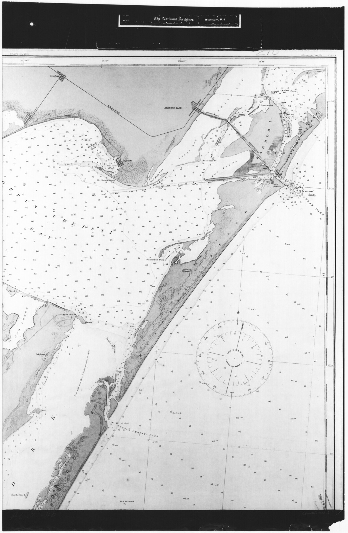
Coast Chart No. 210 Aransas Pass and Corpus Christi Bay with the coast to latitude 27° 12' Texas
RL-2-11b
-
Map/Doc
72806
-
Collection
General Map Collection
-
Object Dates
1913 (Creation Date)
-
People and Organizations
U. S. Coast and Geodetic Survey (Publisher)
-
Counties
Nueces
-
Subjects
Nautical Charts
-
Height x Width
27.9 x 18.3 inches
70.9 x 46.5 cm
-
Comments
B/W photostat copy from National Archives in multiple pieces.
Part of: General Map Collection
Pecos County Rolled Sketch 144

Print $20.00
- Digital $50.00
Pecos County Rolled Sketch 144
1956
Size 28.5 x 29.8 inches
Map/Doc 7277
Hill County Sketch File 24a

Print $40.00
- Digital $50.00
Hill County Sketch File 24a
Size 13.2 x 14.3 inches
Map/Doc 26518
Irion County Working Sketch 17

Print $20.00
- Digital $50.00
Irion County Working Sketch 17
1983
Size 37.4 x 41.6 inches
Map/Doc 66426

Hardin County Sketch File 16

Print $8.00
- Digital $50.00
Hardin County Sketch File 16
Size 8.3 x 11.4 inches
Map/Doc 25125
Kimble County Sketch File A

Print $20.00
- Digital $50.00
Kimble County Sketch File A
1895
Size 17.9 x 18.7 inches
Map/Doc 11933
Hardin County Sketch File 46

Print $8.00
- Digital $50.00
Hardin County Sketch File 46
1875
Size 12.8 x 8.4 inches
Map/Doc 25196
Presidio County Rolled Sketch WR1

Print $20.00
- Digital $50.00
Presidio County Rolled Sketch WR1
1927
Size 20.4 x 23.0 inches
Map/Doc 7421
Right of Way and Track Map Texas & New Orleans R.R. Co. operated by the T. & N. O. R.R. Co. Dallas-Sabine Branch

Print $40.00
- Digital $50.00
Right of Way and Track Map Texas & New Orleans R.R. Co. operated by the T. & N. O. R.R. Co. Dallas-Sabine Branch
1918
Size 26.4 x 56.6 inches
Map/Doc 64152
Galveston Bay Entrance - Galveston and Texas City Harbors

Print $40.00
- Digital $50.00
Galveston Bay Entrance - Galveston and Texas City Harbors
1973
Size 37.0 x 53.0 inches
Map/Doc 69863
Morris County Rolled Sketch 2A

Print $20.00
- Digital $50.00
Morris County Rolled Sketch 2A
Size 24.0 x 18.9 inches
Map/Doc 10244
Working Sketch of Central State Prison Farm, Fort Bend Co., Texas

Print $20.00
- Digital $50.00
Working Sketch of Central State Prison Farm, Fort Bend Co., Texas
Size 38.9 x 16.0 inches
Map/Doc 62996
You may also like
Jefferson County Rolled Sketch 30

Print $20.00
- Digital $50.00
Jefferson County Rolled Sketch 30
1954
Size 34.1 x 39.9 inches
Map/Doc 6392
Ellis County Sketch File 10

Print $40.00
- Digital $50.00
Ellis County Sketch File 10
1860
Size 12.7 x 16.1 inches
Map/Doc 21845
San Patricio County Working Sketch 15

Print $20.00
- Digital $50.00
San Patricio County Working Sketch 15
1951
Size 20.9 x 25.6 inches
Map/Doc 63777
Schleicher County

Print $20.00
- Digital $50.00
Schleicher County
1940
Size 28.8 x 41.2 inches
Map/Doc 77418
Val Verde County Working Sketch 46

Print $20.00
- Digital $50.00
Val Verde County Working Sketch 46
1946
Size 31.8 x 33.3 inches
Map/Doc 72181
[Surveys along the Bosque River]
![260, [Surveys along the Bosque River], General Map Collection](https://historictexasmaps.com/wmedia_w700/maps/260.tif.jpg)
Print $2.00
- Digital $50.00
[Surveys along the Bosque River]
1846
Size 9.3 x 7.8 inches
Map/Doc 260
Bravo Deed, Instrument 24, Tract A and Tract B

Digital $50.00
Bravo Deed, Instrument 24, Tract A and Tract B
Map/Doc 91480
Ector County Working Sketch 2

Print $20.00
- Digital $50.00
Ector County Working Sketch 2
1930
Size 33.1 x 38.2 inches
Map/Doc 68845
Greer County Sketch File 4

Print $4.00
- Digital $50.00
Greer County Sketch File 4
1883
Size 8.6 x 5.5 inches
Map/Doc 24519
Amistad International Reservoir on Rio Grande 74

Print $20.00
- Digital $50.00
Amistad International Reservoir on Rio Grande 74
1949
Size 28.5 x 40.2 inches
Map/Doc 75501
Rusk County Sketch File 40

Print $20.00
Rusk County Sketch File 40
1951
Size 23.2 x 26.6 inches
Map/Doc 12276
St. Louis, Brownsville & Mexico Railway Location Map from Mile 100 to Mile 120

Print $40.00
- Digital $50.00
St. Louis, Brownsville & Mexico Railway Location Map from Mile 100 to Mile 120
1905
Size 19.4 x 67.8 inches
Map/Doc 64168