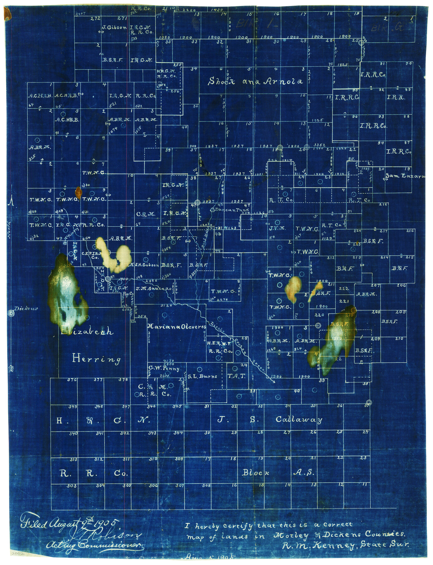
[Kenney's sketch of the surveys in Dickens and Motley Counties]
-
Map/Doc
367
-
Collection
Maddox Collection
-
Object Dates
8/5/1905 (Creation Date)
8/9/1905 (File Date)
-
People and Organizations
J.T. Robison (GLO Commissioner)
R.M. Kenney (Surveyor/Engineer)
-
Counties
Dickens
-
Height x Width
20.1 x 15.7 inches
51.1 x 39.9 cm
-
Medium
blueprint/diazo
-
Comments
Map also refers to Motley County, but this blueprint copy only includes Dickens County.
-
Features
Little Croton Creek
Beef Hollow
Duncan Tank
McKinney Peak
Part of: Maddox Collection
Trinity County, Texas

Print $20.00
- Digital $50.00
Trinity County, Texas
1879
Size 15.8 x 23.8 inches
Map/Doc 761
San Patricio County, Texas

Print $20.00
- Digital $50.00
San Patricio County, Texas
1879
Size 18.1 x 22.8 inches
Map/Doc 611
Map of Kerr County, Texas

Print $20.00
- Digital $50.00
Map of Kerr County, Texas
1879
Size 21.7 x 28.5 inches
Map/Doc 526
Sketch in Hardeman Co.

Print $20.00
- Digital $50.00
Sketch in Hardeman Co.
1890
Size 17.8 x 17.6 inches
Map/Doc 558
Part of Tom Green County, Texas (No. 3)

Print $20.00
- Digital $50.00
Part of Tom Green County, Texas (No. 3)
1870
Size 22.9 x 17.7 inches
Map/Doc 5047
Smithville, Bastrop County, Texas

Print $3.00
- Digital $50.00
Smithville, Bastrop County, Texas
1895
Size 11.0 x 17.2 inches
Map/Doc 531
[Littlefield & White Survey, Kimble County, Texas]
![570, [Littlefield & White Survey, Kimble County, Texas], Maddox Collection](https://historictexasmaps.com/wmedia_w700/maps/0570.tif.jpg)
Print $20.00
- Digital $50.00
[Littlefield & White Survey, Kimble County, Texas]
Size 18.6 x 14.2 inches
Map/Doc 570
Roberts County, Texas

Print $20.00
- Digital $50.00
Roberts County, Texas
1878
Size 19.2 x 18.5 inches
Map/Doc 749
[Surveying Sketch of John Poitevent Block 1, Railroad Lands, et al in Knox County, Texas]
![414, [Surveying Sketch of John Poitevent Block 1, Railroad Lands, et al in Knox County, Texas], Maddox Collection](https://historictexasmaps.com/wmedia_w700/maps/0414.tif.jpg)
Print $3.00
- Digital $50.00
[Surveying Sketch of John Poitevent Block 1, Railroad Lands, et al in Knox County, Texas]
Size 11.9 x 14.2 inches
Map/Doc 414
Sketch No. 1, Dickens & Motley Cos.

Print $20.00
- Digital $50.00
Sketch No. 1, Dickens & Motley Cos.
1879
Size 17.9 x 15.5 inches
Map/Doc 10761
[Surveying Sketch of Mrs. S. C. Alexander, Vicente Salines, J. P. Blessington, et al in Sutton County, Texas]
![75765, [Surveying Sketch of Mrs. S. C. Alexander, Vicente Salines, J. P. Blessington, et al in Sutton County, Texas], Maddox Collection](https://historictexasmaps.com/wmedia_w700/maps/75765.tif.jpg)
Print $20.00
- Digital $50.00
[Surveying Sketch of Mrs. S. C. Alexander, Vicente Salines, J. P. Blessington, et al in Sutton County, Texas]
Size 19.3 x 21.0 inches
Map/Doc 75765
Refugio County, Texas

Print $20.00
- Digital $50.00
Refugio County, Texas
1879
Size 19.9 x 29.0 inches
Map/Doc 600
You may also like
El Paso County Rolled Sketch 66

Print $20.00
- Digital $50.00
El Paso County Rolled Sketch 66
2014
Size 35.1 x 41.2 inches
Map/Doc 93712
[Motley and Foard County School Land Leagues]
![90179, [Motley and Foard County School Land Leagues], Twichell Survey Records](https://historictexasmaps.com/wmedia_w700/maps/90179-1.tif.jpg)
Print $20.00
- Digital $50.00
[Motley and Foard County School Land Leagues]
Size 22.8 x 29.6 inches
Map/Doc 90179
Hale County Sketch File 22

Print $8.00
- Digital $50.00
Hale County Sketch File 22
1903
Size 11.1 x 8.6 inches
Map/Doc 24755

Knox County Working Sketch 9

Print $20.00
- Digital $50.00
Knox County Working Sketch 9
1945
Size 33.8 x 43.3 inches
Map/Doc 70251
Flight Mission No. DIX-8P, Frame 67, Aransas County

Print $20.00
- Digital $50.00
Flight Mission No. DIX-8P, Frame 67, Aransas County
1956
Size 18.7 x 22.4 inches
Map/Doc 83898
The Republic County of Montgomery. December 31, 1838

Print $20.00
The Republic County of Montgomery. December 31, 1838
2020
Size 19.9 x 21.7 inches
Map/Doc 96236
Fort Bend County Rolled Sketch 1

Print $20.00
- Digital $50.00
Fort Bend County Rolled Sketch 1
Size 24.3 x 27.5 inches
Map/Doc 5891
Nacogdoches County Working Sketch 1

Print $20.00
- Digital $50.00
Nacogdoches County Working Sketch 1
Size 27.8 x 35.8 inches
Map/Doc 71217
Flight Mission No. DAG-18K, Frame 68, Matagorda County

Print $20.00
- Digital $50.00
Flight Mission No. DAG-18K, Frame 68, Matagorda County
1952
Size 16.4 x 16.3 inches
Map/Doc 86361
Fractional Township No. 8 South Range No. 2 East of the Indian Meridian, Indian Territory

Print $20.00
- Digital $50.00
Fractional Township No. 8 South Range No. 2 East of the Indian Meridian, Indian Territory
1898
Size 19.3 x 24.3 inches
Map/Doc 75204
Orange County Rolled Sketch 27

Print $20.00
- Digital $50.00
Orange County Rolled Sketch 27
1954
Size 22.3 x 34.5 inches
Map/Doc 7186