[Old Coastal Chart of Texas Coast showing passes with depth readings]
Print $40.00
- Digital $50.00
[Old Coastal Chart of Texas Coast showing passes with depth readings]
Size: 25.4 x 48.6 inches
4662
[Coastal Chart of Galveston Island, Bolivar Peninsula and Galveston Bay]
Print $20.00
- Digital $50.00
[Coastal Chart of Galveston Island, Bolivar Peninsula and Galveston Bay]
Size: 24.0 x 18.1 inches
61804
Texas, Matagorda Peninsula, Cotton Bayou

Print $6.00
- Digital $50.00
Texas, Matagorda Peninsula, Cotton Bayou
Size: 31.5 x 34.6 inches
69986
Coast of Texas and its defences

Print $20.00
- Digital $50.00
Coast of Texas and its defences
Size: 27.8 x 18.2 inches
72684
Coast of Texas and its defences

Print $20.00
- Digital $50.00
Coast of Texas and its defences
Size: 27.6 x 18.2 inches
72685
United States - Gulf Coast - Galveston to Rio Grande

Print $20.00
- Digital $50.00
United States - Gulf Coast - Galveston to Rio Grande
Size: 27.9 x 18.3 inches
72739
United States - Gulf Coast - Galveston to Rio Grande

Print $20.00
- Digital $50.00
United States - Gulf Coast - Galveston to Rio Grande
Size: 27.8 x 18.1 inches
72740
United States - Gulf Coast - Galveston to Rio Grande

Print $20.00
- Digital $50.00
United States - Gulf Coast - Galveston to Rio Grande
Size: 27.7 x 18.3 inches
72741
United States - Gulf Coast - Galveston to Rio Grande

Print $20.00
- Digital $50.00
United States - Gulf Coast - Galveston to Rio Grande
Size: 27.9 x 18.3 inches
72742
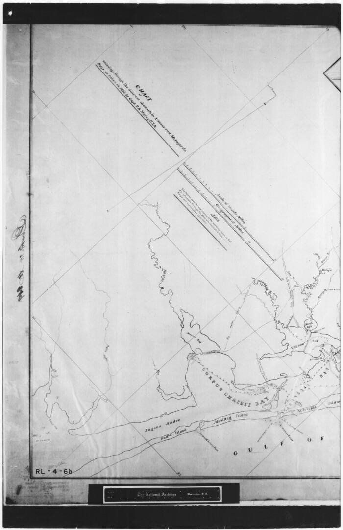
Chart of soundings through the different channels in Aransas and Matagorda Bays as taken in 1855 by Capt. R. B. Marey, U. S. A. [Inset: Harbour of Lamar and Live-Oak Pt.]
Print $20.00
- Digital $50.00
Chart of soundings through the different channels in Aransas and Matagorda Bays as taken in 1855 by Capt. R. B. Marey, U. S. A. [Inset: Harbour of Lamar and Live-Oak Pt.]
Size: 28.1 x 18.2 inches
72977
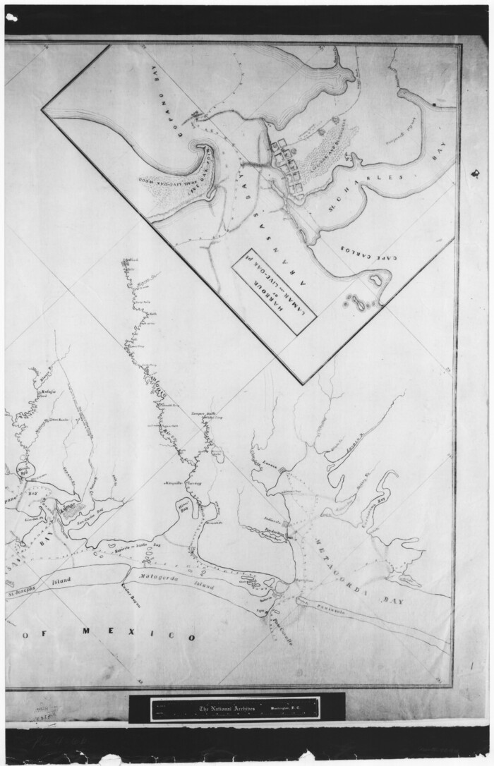
Chart of soundings through the different channels in Aransas and Matagorda Bays as taken in 1855 by Capt. R. B. Marey, U. S. A. [Inset: Harbour of Lamar and Live-Oak Pt.]
Print $20.00
- Digital $50.00
Chart of soundings through the different channels in Aransas and Matagorda Bays as taken in 1855 by Capt. R. B. Marey, U. S. A. [Inset: Harbour of Lamar and Live-Oak Pt.]
Size: 28.4 x 18.3 inches
72978
Sketch exhibiting the San Antonio River from the source to the fork of Goliad

Print $20.00
- Digital $50.00
Sketch exhibiting the San Antonio River from the source to the fork of Goliad
Size: 27.5 x 16.6 inches
73009
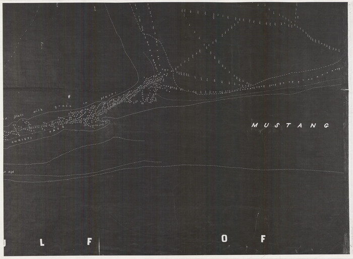
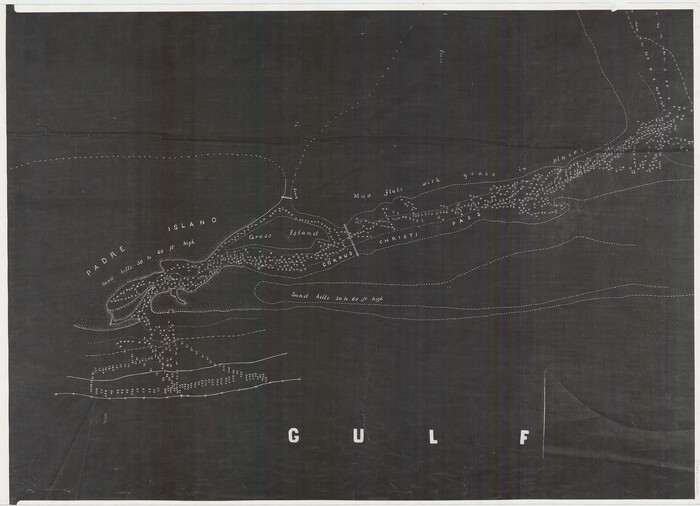
[Nueces Bay, Mustang Island and Padre Island]
Print $4.00
- Digital $50.00
[Nueces Bay, Mustang Island and Padre Island]
Size: 18.1 x 24.7 inches
73465
[Nueces Bay, Mustang Island and Padre Island]
Print $4.00
- Digital $50.00
[Nueces Bay, Mustang Island and Padre Island]
Size: 18.3 x 25.3 inches
73466
Texas Intracoastal Waterway - Laguna Madre - Dagger Hill to Potrero Grande

Print $20.00
- Digital $50.00
Texas Intracoastal Waterway - Laguna Madre - Dagger Hill to Potrero Grande
Size: 39.0 x 27.3 inches
73508
Laguna Madre, T-9209

Print $20.00
- Digital $50.00
Laguna Madre, T-9209
Size: 34.0 x 30.8 inches
73600
Laguna Madre, T-9210

Print $20.00
- Digital $50.00
Laguna Madre, T-9210
Size: 34.6 x 31.9 inches
73601
Laguna Madre, T-9211

Print $20.00
- Digital $50.00
Laguna Madre, T-9211
Size: 33.0 x 31.1 inches
73602
Laguna Madre, T-9212

Print $20.00
- Digital $50.00
Laguna Madre, T-9212
Size: 33.1 x 31.4 inches
73603
United States Great Lakes and adjacent waterways

Print $20.00
- Digital $50.00
United States Great Lakes and adjacent waterways
Size: 20.8 x 42.2 inches
76121
United States Great Lakes and adjacent waterways

Print $20.00
- Digital $50.00
United States Great Lakes and adjacent waterways
Size: 20.8 x 42.7 inches
76122
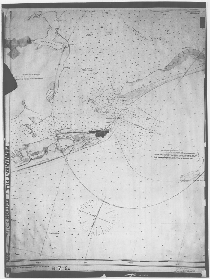
Galveston Bay Entrance - Galveston and Texas City Harbors

Print $40.00
- Digital $50.00
Galveston Bay Entrance - Galveston and Texas City Harbors
Size: 38.3 x 54.8 inches
78271
Corpus Christi Pass

Print $20.00
- Digital $50.00
Corpus Christi Pass
Size: 45.7 x 41.2 inches
78454
Corpus Christi Pass

Print $20.00
- Digital $50.00
Corpus Christi Pass
Size: 46.2 x 41.4 inches
78455
Preliminary Chart of Entrance to Brazos River, Texas

Print $20.00
- Digital $50.00
Preliminary Chart of Entrance to Brazos River, Texas
Size: 17.6 x 19.8 inches
81986
Louisiana and Texas Intracoastal Waterway

Print $20.00
- Digital $50.00
Louisiana and Texas Intracoastal Waterway
Size: 13.9 x 19.0 inches
83347
Sabine and Neches Rivers

Print $20.00
- Digital $50.00
Sabine and Neches Rivers
Size: 19.6 x 43.7 inches
94444
Chocolate Bayou, Texas showing proposed connection from its mouth to West Galveston Bay for a Light Draft Navigation

Print $20.00
- Digital $50.00
Chocolate Bayou, Texas showing proposed connection from its mouth to West Galveston Bay for a Light Draft Navigation
Size: 13.2 x 20.4 inches
96557
Index Map to the Charts Published by the U.S. Coast and Geodetic Survey - Gulf Coast, Ship Shoal to the Rio Grande

Print $20.00
- Digital $50.00
Index Map to the Charts Published by the U.S. Coast and Geodetic Survey - Gulf Coast, Ship Shoal to the Rio Grande
Size: 21.5 x 26.4 inches
96559
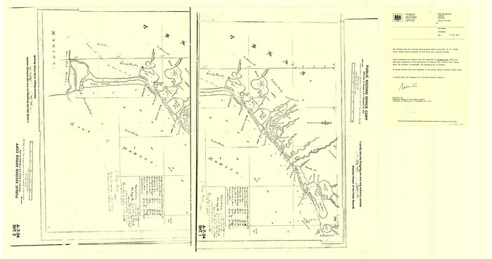
Sketch showing the progress of the survey in Sections 8 & 9 from 1846 to 1882

Print $20.00
- Digital $50.00
Sketch showing the progress of the survey in Sections 8 & 9 from 1846 to 1882
Size: 21.8 x 37.2 inches
96560
[Old Coastal Chart of Texas Coast showing passes with depth readings]
Print $40.00
- Digital $50.00
[Old Coastal Chart of Texas Coast showing passes with depth readings]
-
Size
25.4 x 48.6 inches
-
Map/Doc
4662
[Coastal Chart of Galveston Island, Bolivar Peninsula and Galveston Bay]
Print $20.00
- Digital $50.00
[Coastal Chart of Galveston Island, Bolivar Peninsula and Galveston Bay]
-
Size
24.0 x 18.1 inches
-
Map/Doc
61804
Texas, Matagorda Peninsula, Cotton Bayou
Print $6.00
- Digital $50.00
Texas, Matagorda Peninsula, Cotton Bayou
-
Size
31.5 x 34.6 inches
-
Map/Doc
69986
Coast of Texas and its defences
Print $20.00
- Digital $50.00
Coast of Texas and its defences
-
Size
27.8 x 18.2 inches
-
Map/Doc
72684
Coast of Texas and its defences
Print $20.00
- Digital $50.00
Coast of Texas and its defences
-
Size
27.6 x 18.2 inches
-
Map/Doc
72685
United States - Gulf Coast - Galveston to Rio Grande
Print $20.00
- Digital $50.00
United States - Gulf Coast - Galveston to Rio Grande
-
Size
27.9 x 18.3 inches
-
Map/Doc
72739
United States - Gulf Coast - Galveston to Rio Grande
Print $20.00
- Digital $50.00
United States - Gulf Coast - Galveston to Rio Grande
-
Size
27.8 x 18.1 inches
-
Map/Doc
72740
United States - Gulf Coast - Galveston to Rio Grande
Print $20.00
- Digital $50.00
United States - Gulf Coast - Galveston to Rio Grande
-
Size
27.7 x 18.3 inches
-
Map/Doc
72741
United States - Gulf Coast - Galveston to Rio Grande
Print $20.00
- Digital $50.00
United States - Gulf Coast - Galveston to Rio Grande
-
Size
27.9 x 18.3 inches
-
Map/Doc
72742
Chart of soundings through the different channels in Aransas and Matagorda Bays as taken in 1855 by Capt. R. B. Marey, U. S. A. [Inset: Harbour of Lamar and Live-Oak Pt.]
Print $20.00
- Digital $50.00
Chart of soundings through the different channels in Aransas and Matagorda Bays as taken in 1855 by Capt. R. B. Marey, U. S. A. [Inset: Harbour of Lamar and Live-Oak Pt.]
-
Size
28.1 x 18.2 inches
-
Map/Doc
72977
Chart of soundings through the different channels in Aransas and Matagorda Bays as taken in 1855 by Capt. R. B. Marey, U. S. A. [Inset: Harbour of Lamar and Live-Oak Pt.]
Print $20.00
- Digital $50.00
Chart of soundings through the different channels in Aransas and Matagorda Bays as taken in 1855 by Capt. R. B. Marey, U. S. A. [Inset: Harbour of Lamar and Live-Oak Pt.]
-
Size
28.4 x 18.3 inches
-
Map/Doc
72978
Sketch exhibiting the San Antonio River from the source to the fork of Goliad
Print $20.00
- Digital $50.00
Sketch exhibiting the San Antonio River from the source to the fork of Goliad
-
Size
27.5 x 16.6 inches
-
Map/Doc
73009
[Nueces Bay, Mustang Island and Padre Island]
Print $4.00
- Digital $50.00
[Nueces Bay, Mustang Island and Padre Island]
-
Size
18.1 x 24.7 inches
-
Map/Doc
73465
[Nueces Bay, Mustang Island and Padre Island]
Print $4.00
- Digital $50.00
[Nueces Bay, Mustang Island and Padre Island]
-
Size
18.3 x 25.3 inches
-
Map/Doc
73466
Texas Intracoastal Waterway - Laguna Madre - Dagger Hill to Potrero Grande
Print $20.00
- Digital $50.00
Texas Intracoastal Waterway - Laguna Madre - Dagger Hill to Potrero Grande
-
Size
39.0 x 27.3 inches
-
Map/Doc
73508
Laguna Madre, T-9209
Print $20.00
- Digital $50.00
Laguna Madre, T-9209
-
Size
34.0 x 30.8 inches
-
Map/Doc
73600
Laguna Madre, T-9210
Print $20.00
- Digital $50.00
Laguna Madre, T-9210
-
Size
34.6 x 31.9 inches
-
Map/Doc
73601
Laguna Madre, T-9211
Print $20.00
- Digital $50.00
Laguna Madre, T-9211
-
Size
33.0 x 31.1 inches
-
Map/Doc
73602
Laguna Madre, T-9212
Print $20.00
- Digital $50.00
Laguna Madre, T-9212
-
Size
33.1 x 31.4 inches
-
Map/Doc
73603
United States Great Lakes and adjacent waterways
Print $20.00
- Digital $50.00
United States Great Lakes and adjacent waterways
-
Size
20.8 x 42.2 inches
-
Map/Doc
76121
United States Great Lakes and adjacent waterways
Print $20.00
- Digital $50.00
United States Great Lakes and adjacent waterways
-
Size
20.8 x 42.7 inches
-
Map/Doc
76122
Galveston Bay Entrance - Galveston and Texas City Harbors
Print $40.00
- Digital $50.00
Galveston Bay Entrance - Galveston and Texas City Harbors
-
Size
38.3 x 54.8 inches
-
Map/Doc
78271
Corpus Christi Pass
Print $20.00
- Digital $50.00
Corpus Christi Pass
-
Size
45.7 x 41.2 inches
-
Map/Doc
78454
Corpus Christi Pass
Print $20.00
- Digital $50.00
Corpus Christi Pass
-
Size
46.2 x 41.4 inches
-
Map/Doc
78455
Preliminary Chart of Entrance to Brazos River, Texas
Print $20.00
- Digital $50.00
Preliminary Chart of Entrance to Brazos River, Texas
-
Size
17.6 x 19.8 inches
-
Map/Doc
81986
Louisiana and Texas Intracoastal Waterway
Print $20.00
- Digital $50.00
Louisiana and Texas Intracoastal Waterway
-
Size
13.9 x 19.0 inches
-
Map/Doc
83347
Sabine and Neches Rivers
Print $20.00
- Digital $50.00
Sabine and Neches Rivers
-
Size
19.6 x 43.7 inches
-
Map/Doc
94444
Chocolate Bayou, Texas showing proposed connection from its mouth to West Galveston Bay for a Light Draft Navigation
Print $20.00
- Digital $50.00
Chocolate Bayou, Texas showing proposed connection from its mouth to West Galveston Bay for a Light Draft Navigation
-
Size
13.2 x 20.4 inches
-
Map/Doc
96557
Index Map to the Charts Published by the U.S. Coast and Geodetic Survey - Gulf Coast, Ship Shoal to the Rio Grande
Print $20.00
- Digital $50.00
Index Map to the Charts Published by the U.S. Coast and Geodetic Survey - Gulf Coast, Ship Shoal to the Rio Grande
-
Size
21.5 x 26.4 inches
-
Map/Doc
96559
Sketch showing the progress of the survey in Sections 8 & 9 from 1846 to 1882
Print $20.00
- Digital $50.00
Sketch showing the progress of the survey in Sections 8 & 9 from 1846 to 1882
-
Size
21.8 x 37.2 inches
-
Map/Doc
96560