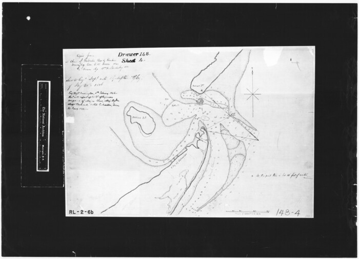
[Photostats of section of Hydrographic Surveys H-5399, H-4822 and H-470, Mouth of Trinity River]
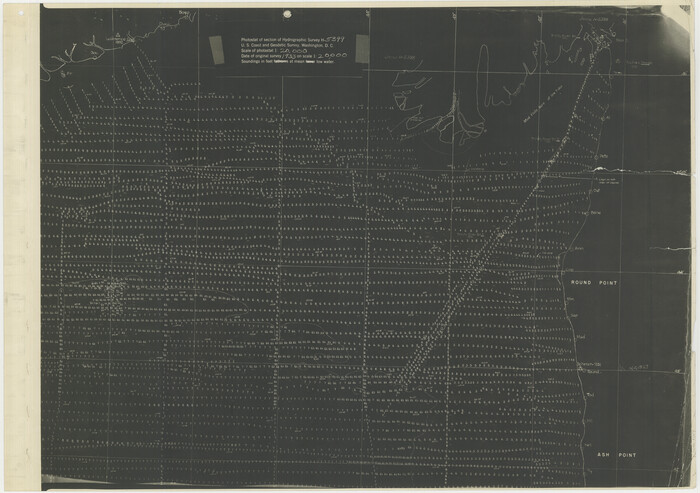
Print $20.00
- Digital $50.00
[Photostats of section of Hydrographic Surveys H-5399, H-4822 and H-470, Mouth of Trinity River]
1933
Size: 18.2 x 25.8 inches
61154
[Old Coastal Chart showing Brazo Chico, Brazo de Santiago and Rio Bravo del Norte passes with depth readings]
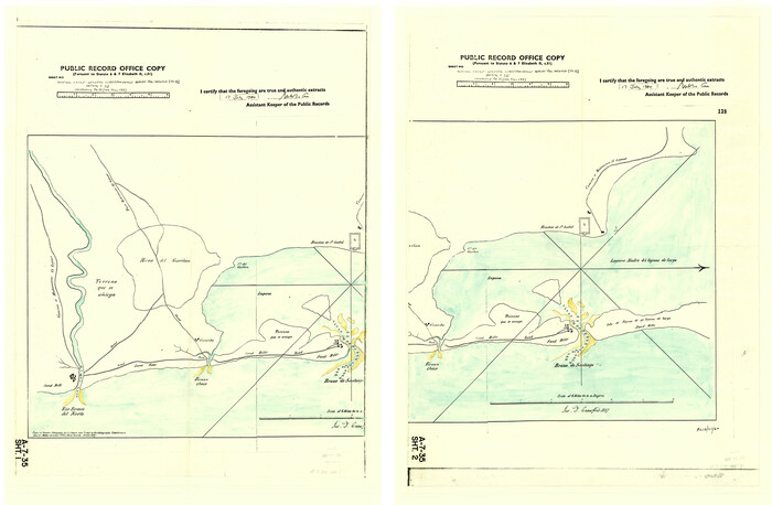
Print $20.00
- Digital $50.00
[Old Coastal Chart showing Brazo Chico, Brazo de Santiago and Rio Bravo del Norte passes with depth readings]
1837
Size: 25.7 x 39.3 inches
4661
[Old Coastal Chart of Texas Coast showing passes with depth readings]
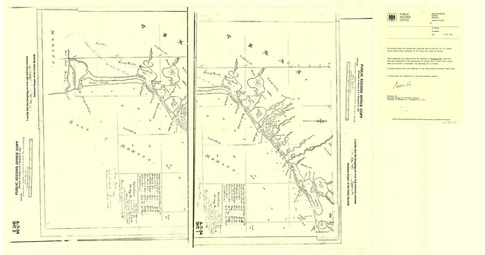
Print $40.00
- Digital $50.00
[Old Coastal Chart of Texas Coast showing passes with depth readings]
Size: 25.4 x 48.6 inches
4662
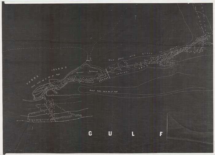
[Nueces Bay, Mustang Island and Padre Island]
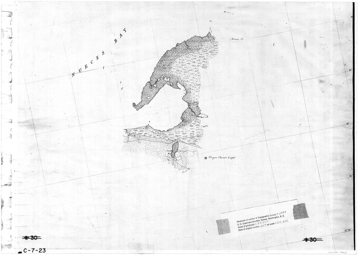
Print $4.00
- Digital $50.00
[Nueces Bay, Mustang Island and Padre Island]
1887
Size: 18.5 x 26.2 inches
73463
[Nueces Bay, Mustang Island and Padre Island]
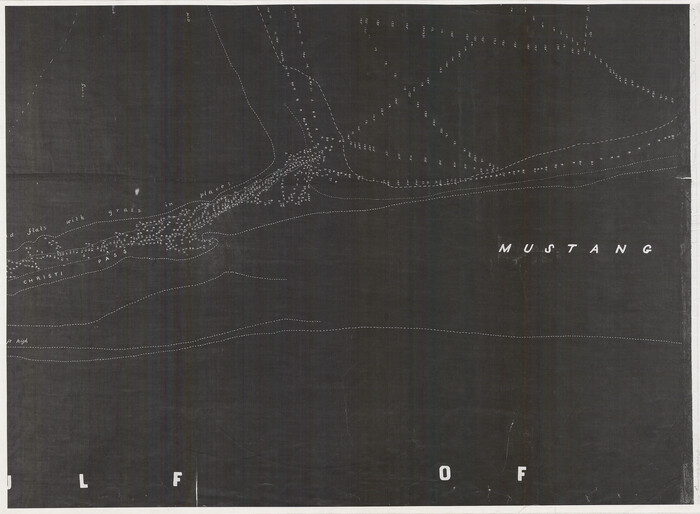
Print $4.00
- Digital $50.00
[Nueces Bay, Mustang Island and Padre Island]
Size: 18.1 x 24.7 inches
73465
[Nueces Bay, Mustang Island and Padre Island]
Print $4.00
- Digital $50.00
[Nueces Bay, Mustang Island and Padre Island]
Size: 18.3 x 25.3 inches
73466
[Folder for] Nautical Chart 11305: Texas Intracoastal Waterway, Laguna Madre, Rincon de San Jose to Chubby Island
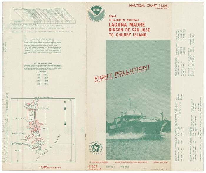
Print $20.00
- Digital $50.00
[Folder for] Nautical Chart 11305: Texas Intracoastal Waterway, Laguna Madre, Rincon de San Jose to Chubby Island
1976
Size: 16.0 x 19.0 inches
75913
[Folder for] Nautical Chart 11303: Texas Intracoastal Waterway, Laguna Madre, Chubby Island to Stover Point including the Arroyo Colorado
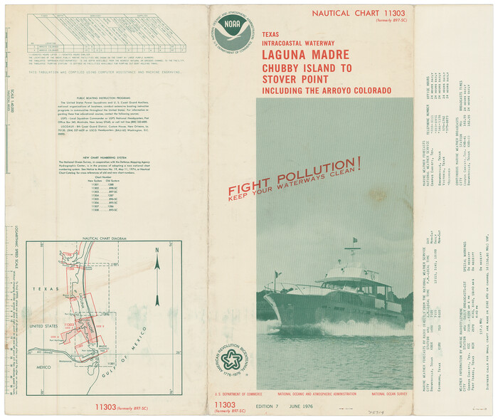
Print $20.00
- Digital $50.00
[Folder for] Nautical Chart 11303: Texas Intracoastal Waterway, Laguna Madre, Chubby Island to Stover Point including the Arroyo Colorado
1976
Size: 15.9 x 18.8 inches
75914
[Copied from a chart of Galveston Bar and Harbor]
Print $20.00
- Digital $50.00
[Copied from a chart of Galveston Bar and Harbor]
1846
Size: 18.3 x 25.3 inches
72760
[Coastal Chart of Galveston Island, Bolivar Peninsula and Galveston Bay]
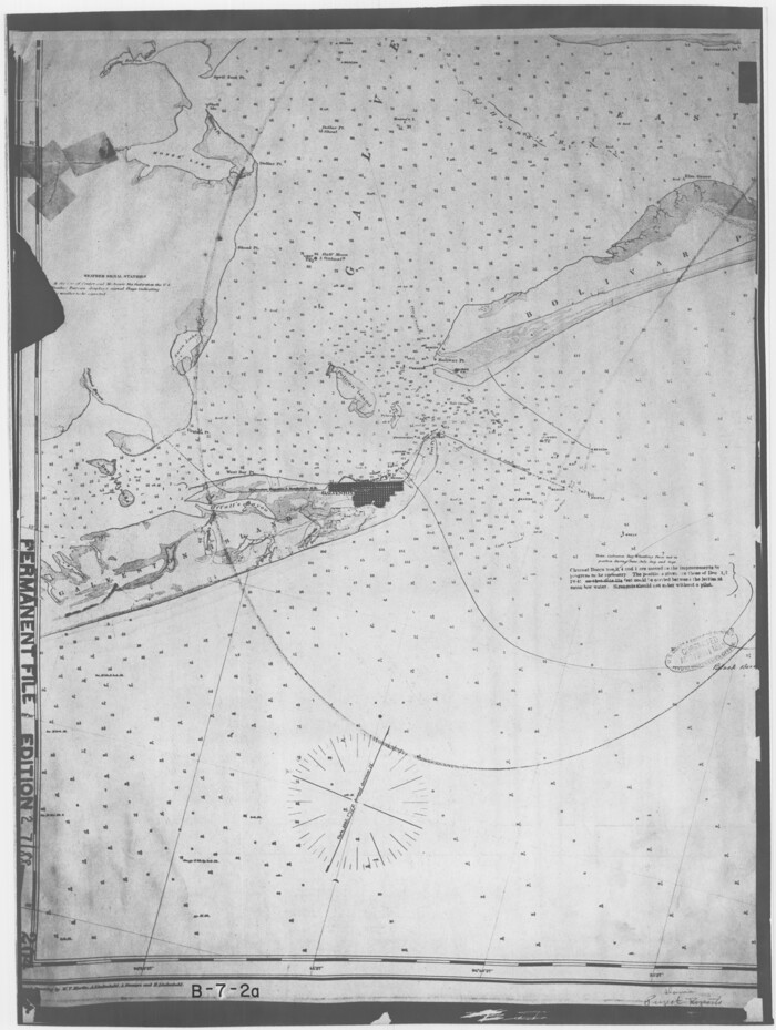
Print $20.00
- Digital $50.00
[Coastal Chart of Galveston Island, Bolivar Peninsula and Galveston Bay]
Size: 24.0 x 18.1 inches
61804
Where Did Columbus Discover America?

Where Did Columbus Discover America?
1986
Size: 14.7 x 20.6 inches
96837
West End of Copano Bay and Town of Saint Marys, Texas

Print $40.00
- Digital $50.00
West End of Copano Bay and Town of Saint Marys, Texas
1861
Size: 54.5 x 32.9 inches
73428
Vicinity of San Luis Pass, Galveston Island, Texas

Print $40.00
- Digital $50.00
Vicinity of San Luis Pass, Galveston Island, Texas
1933
Size: 36.9 x 57.2 inches
69942
Vicinity of San Luis Pass, Galveston Island, Texas

Print $40.00
- Digital $50.00
Vicinity of San Luis Pass, Galveston Island, Texas
1933
Size: 37.1 x 57.8 inches
69943
Upper Galveston Bay, Houston Ship Channel, Dollar Pt. to Atkinson I.

Print $40.00
- Digital $50.00
Upper Galveston Bay, Houston Ship Channel, Dollar Pt. to Atkinson I.
1971
Size: 49.3 x 36.4 inches
69894
Upper Galveston Bay, Houston Ship Channel, Dollar Pt. to Atkinson I.

Print $40.00
- Digital $50.00
Upper Galveston Bay, Houston Ship Channel, Dollar Pt. to Atkinson I.
1972
Size: 49.9 x 36.9 inches
69895
Upper Galveston Bay, Houston Ship Channel, Dollar Pt. to Atkinson I.

Print $40.00
- Digital $50.00
Upper Galveston Bay, Houston Ship Channel, Dollar Pt. to Atkinson I.
1973
Size: 49.8 x 36.8 inches
69896
Upper Galveston Bay, Houston Ship Channel, Dollar Pt. to Atkinson I.

Print $40.00
- Digital $50.00
Upper Galveston Bay, Houston Ship Channel, Dollar Pt. to Atkinson I.
1976
Size: 49.3 x 36.5 inches
69897
Upper Galveston Bay, Houston Ship Channel, Dollar Pt. to Atkinson I.

Print $40.00
- Digital $50.00
Upper Galveston Bay, Houston Ship Channel, Dollar Pt. to Atkinson I.
1978
Size: 49.3 x 36.8 inches
69898
Upper Galveston Bay, Houston Ship Channel, Dollar Pt. to Atkinson I.

Print $40.00
- Digital $50.00
Upper Galveston Bay, Houston Ship Channel, Dollar Pt. to Atkinson I.
1992
Size: 49.2 x 37.0 inches
69899
United States Gulf Coast - from Galveston to the Rio Grande

Print $20.00
- Digital $50.00
United States Gulf Coast - from Galveston to the Rio Grande
1915
Size: 26.3 x 18.3 inches
72731
United States Gulf Coast - from Galveston to the Rio Grande

Print $20.00
- Digital $50.00
United States Gulf Coast - from Galveston to the Rio Grande
1915
Size: 26.9 x 18.3 inches
72732
United States Gulf Coast - from Galveston to the Rio Grande

Print $20.00
- Digital $50.00
United States Gulf Coast - from Galveston to the Rio Grande
1915
Size: 26.4 x 18.2 inches
72733
United States Gulf Coast - from Galveston to the Rio Grande

Print $20.00
- Digital $50.00
United States Gulf Coast - from Galveston to the Rio Grande
1915
Size: 26.6 x 18.3 inches
72734
United States Great Lakes and adjacent waterways

Print $20.00
- Digital $50.00
United States Great Lakes and adjacent waterways
Size: 20.8 x 42.2 inches
76121
United States Great Lakes and adjacent waterways

Print $20.00
- Digital $50.00
United States Great Lakes and adjacent waterways
Size: 20.8 x 42.7 inches
76122
United States Bathymetric and Fishing Maps including Topographic/Bathymetric Maps

Print $40.00
- Digital $50.00
United States Bathymetric and Fishing Maps including Topographic/Bathymetric Maps
1989
Size: 21.8 x 54.8 inches
73556
United States Bathymetric and Fishing Maps including Topographic/Bathymetric Maps

Print $40.00
- Digital $50.00
United States Bathymetric and Fishing Maps including Topographic/Bathymetric Maps
1989
Size: 20.4 x 54.4 inches
73557
[Sabine Pass]
![73343, [Sabine Pass], General Map Collection](https://historictexasmaps.com/wmedia_w700/maps/73343.tif.jpg)
Print $20.00
- Digital $50.00
[Sabine Pass]
1916
-
Size
18.5 x 26.5 inches
-
Map/Doc
73343
-
Creation Date
1916
[Sabine Pass]
![78263, [Sabine Pass], General Map Collection](https://historictexasmaps.com/wmedia_w700/maps/78263.tif.jpg)
Print $20.00
- Digital $50.00
[Sabine Pass]
1916
-
Size
29.2 x 42.1 inches
-
Map/Doc
78263
-
Creation Date
1916
[Photostats of section of Hydrographic Surveys H-5399, H-4822 and H-470, Mouth of Trinity River]
Print $20.00
- Digital $50.00
[Photostats of section of Hydrographic Surveys H-5399, H-4822 and H-470, Mouth of Trinity River]
1933
-
Size
18.2 x 25.8 inches
-
Map/Doc
61154
-
Creation Date
1933
[Old Coastal Chart showing Brazo Chico, Brazo de Santiago and Rio Bravo del Norte passes with depth readings]
Print $20.00
- Digital $50.00
[Old Coastal Chart showing Brazo Chico, Brazo de Santiago and Rio Bravo del Norte passes with depth readings]
1837
-
Size
25.7 x 39.3 inches
-
Map/Doc
4661
-
Creation Date
1837
[Old Coastal Chart of Texas Coast showing passes with depth readings]
Print $40.00
- Digital $50.00
[Old Coastal Chart of Texas Coast showing passes with depth readings]
-
Size
25.4 x 48.6 inches
-
Map/Doc
4662
[Nueces Bay, Mustang Island and Padre Island]
Print $4.00
- Digital $50.00
[Nueces Bay, Mustang Island and Padre Island]
1887
-
Size
18.5 x 26.2 inches
-
Map/Doc
73463
-
Creation Date
1887
[Nueces Bay, Mustang Island and Padre Island]
Print $4.00
- Digital $50.00
[Nueces Bay, Mustang Island and Padre Island]
-
Size
18.1 x 24.7 inches
-
Map/Doc
73465
[Nueces Bay, Mustang Island and Padre Island]
Print $4.00
- Digital $50.00
[Nueces Bay, Mustang Island and Padre Island]
-
Size
18.3 x 25.3 inches
-
Map/Doc
73466
[Folder for] Nautical Chart 11305: Texas Intracoastal Waterway, Laguna Madre, Rincon de San Jose to Chubby Island
Print $20.00
- Digital $50.00
[Folder for] Nautical Chart 11305: Texas Intracoastal Waterway, Laguna Madre, Rincon de San Jose to Chubby Island
1976
-
Size
16.0 x 19.0 inches
-
Map/Doc
75913
-
Creation Date
1976
[Folder for] Nautical Chart 11303: Texas Intracoastal Waterway, Laguna Madre, Chubby Island to Stover Point including the Arroyo Colorado
Print $20.00
- Digital $50.00
[Folder for] Nautical Chart 11303: Texas Intracoastal Waterway, Laguna Madre, Chubby Island to Stover Point including the Arroyo Colorado
1976
-
Size
15.9 x 18.8 inches
-
Map/Doc
75914
-
Creation Date
1976
[Copied from a chart of Galveston Bar and Harbor]
Print $20.00
- Digital $50.00
[Copied from a chart of Galveston Bar and Harbor]
1846
-
Size
18.3 x 25.3 inches
-
Map/Doc
72760
-
Creation Date
1846
[Coastal Chart of Galveston Island, Bolivar Peninsula and Galveston Bay]
Print $20.00
- Digital $50.00
[Coastal Chart of Galveston Island, Bolivar Peninsula and Galveston Bay]
-
Size
24.0 x 18.1 inches
-
Map/Doc
61804
Where Did Columbus Discover America?
Where Did Columbus Discover America?
1986
-
Size
14.7 x 20.6 inches
-
Map/Doc
96837
-
Creation Date
1986
West End of Copano Bay and Town of Saint Marys, Texas
Print $40.00
- Digital $50.00
West End of Copano Bay and Town of Saint Marys, Texas
1861
-
Size
54.5 x 32.9 inches
-
Map/Doc
73428
-
Creation Date
1861
Vicinity of San Luis Pass, Galveston Island, Texas
Print $40.00
- Digital $50.00
Vicinity of San Luis Pass, Galveston Island, Texas
1933
-
Size
36.9 x 57.2 inches
-
Map/Doc
69942
-
Creation Date
1933
Vicinity of San Luis Pass, Galveston Island, Texas
Print $40.00
- Digital $50.00
Vicinity of San Luis Pass, Galveston Island, Texas
1933
-
Size
37.1 x 57.8 inches
-
Map/Doc
69943
-
Creation Date
1933
Upper Galveston Bay, Houston Ship Channel, Dollar Pt. to Atkinson I.
Print $40.00
- Digital $50.00
Upper Galveston Bay, Houston Ship Channel, Dollar Pt. to Atkinson I.
1971
-
Size
49.3 x 36.4 inches
-
Map/Doc
69894
-
Creation Date
1971
Upper Galveston Bay, Houston Ship Channel, Dollar Pt. to Atkinson I.
Print $40.00
- Digital $50.00
Upper Galveston Bay, Houston Ship Channel, Dollar Pt. to Atkinson I.
1972
-
Size
49.9 x 36.9 inches
-
Map/Doc
69895
-
Creation Date
1972
Upper Galveston Bay, Houston Ship Channel, Dollar Pt. to Atkinson I.
Print $40.00
- Digital $50.00
Upper Galveston Bay, Houston Ship Channel, Dollar Pt. to Atkinson I.
1973
-
Size
49.8 x 36.8 inches
-
Map/Doc
69896
-
Creation Date
1973
Upper Galveston Bay, Houston Ship Channel, Dollar Pt. to Atkinson I.
Print $40.00
- Digital $50.00
Upper Galveston Bay, Houston Ship Channel, Dollar Pt. to Atkinson I.
1976
-
Size
49.3 x 36.5 inches
-
Map/Doc
69897
-
Creation Date
1976
Upper Galveston Bay, Houston Ship Channel, Dollar Pt. to Atkinson I.
Print $40.00
- Digital $50.00
Upper Galveston Bay, Houston Ship Channel, Dollar Pt. to Atkinson I.
1978
-
Size
49.3 x 36.8 inches
-
Map/Doc
69898
-
Creation Date
1978
Upper Galveston Bay, Houston Ship Channel, Dollar Pt. to Atkinson I.
Print $40.00
- Digital $50.00
Upper Galveston Bay, Houston Ship Channel, Dollar Pt. to Atkinson I.
1992
-
Size
49.2 x 37.0 inches
-
Map/Doc
69899
-
Creation Date
1992
United States Gulf Coast - from Galveston to the Rio Grande
Print $20.00
- Digital $50.00
United States Gulf Coast - from Galveston to the Rio Grande
1915
-
Size
26.3 x 18.3 inches
-
Map/Doc
72731
-
Creation Date
1915
United States Gulf Coast - from Galveston to the Rio Grande
Print $20.00
- Digital $50.00
United States Gulf Coast - from Galveston to the Rio Grande
1915
-
Size
26.9 x 18.3 inches
-
Map/Doc
72732
-
Creation Date
1915
United States Gulf Coast - from Galveston to the Rio Grande
Print $20.00
- Digital $50.00
United States Gulf Coast - from Galveston to the Rio Grande
1915
-
Size
26.4 x 18.2 inches
-
Map/Doc
72733
-
Creation Date
1915
United States Gulf Coast - from Galveston to the Rio Grande
Print $20.00
- Digital $50.00
United States Gulf Coast - from Galveston to the Rio Grande
1915
-
Size
26.6 x 18.3 inches
-
Map/Doc
72734
-
Creation Date
1915
United States Great Lakes and adjacent waterways
Print $20.00
- Digital $50.00
United States Great Lakes and adjacent waterways
-
Size
20.8 x 42.2 inches
-
Map/Doc
76121
United States Great Lakes and adjacent waterways
Print $20.00
- Digital $50.00
United States Great Lakes and adjacent waterways
-
Size
20.8 x 42.7 inches
-
Map/Doc
76122
United States Bathymetric and Fishing Maps including Topographic/Bathymetric Maps
Print $40.00
- Digital $50.00
United States Bathymetric and Fishing Maps including Topographic/Bathymetric Maps
1989
-
Size
21.8 x 54.8 inches
-
Map/Doc
73556
-
Creation Date
1989
United States Bathymetric and Fishing Maps including Topographic/Bathymetric Maps
Print $40.00
- Digital $50.00
United States Bathymetric and Fishing Maps including Topographic/Bathymetric Maps
1989
-
Size
20.4 x 54.4 inches
-
Map/Doc
73557
-
Creation Date
1989