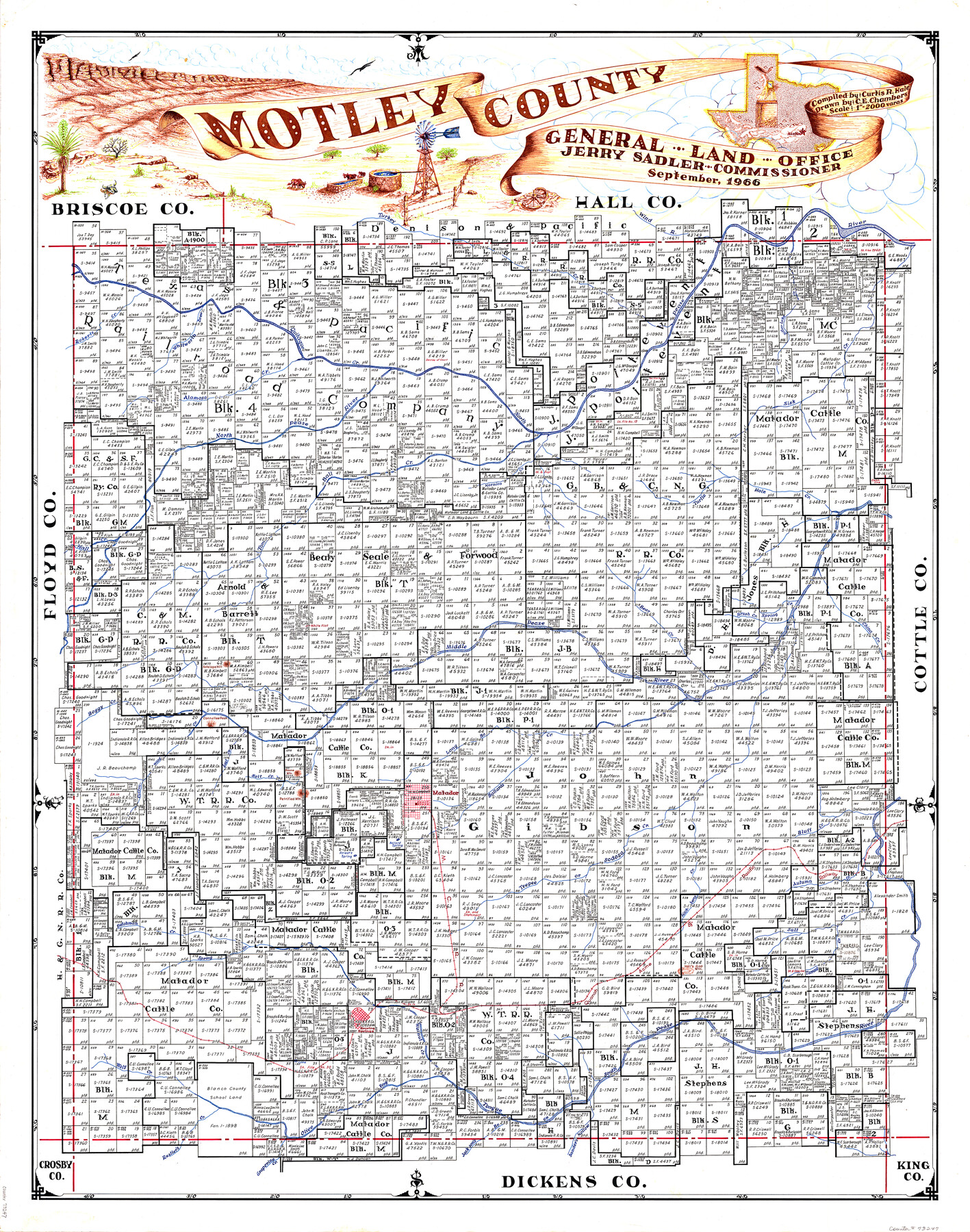
Motley County
-
Map/Doc
73247
-
Collection
General Map Collection
-
Object Dates
1966 (Creation Date)
-
People and Organizations
Texas General Land Office (Publisher)
Curtis R. Hale (Compiler)
Jerry Sadler (GLO Commissioner)
C.E. Chambers (Draftsman)
-
Counties
Motley
-
Subjects
County
-
Height x Width
43.8 x 34.8 inches
111.3 x 88.4 cm
-
Comments
Hand lettered.
-
Features
Tongue River
Matador
Pease River
Cottonwood Creek
Connellee Peak
Boggy Creek
Ballard Spring
Tee Pee Creek
Sodosa Creek
MCR
Priest's Spring
Dutchman Creek
QA&P
Hell's Gap Mountain
Hackberry Creek
Tarrant Creek
South Pease River
Walnut Creek
Roaring Springs
Olive Fork
Wolf Creek
Rustler's Creek
Grapevine Creek
Jackson's Branch
Sander's Hollow
White Flat
Antelope Hill
Bear Creek
Whitworth Draw
Quitaque Creek
Turkey Creek
Wind Creek
North Pease River
Bitter Lake Creek
Sisk Creek
Alamosa Creek
Tom Ball Creek
Hornica Creek
Turtle Hole Creek
Hall Creek
Middle Pease River
Roberts Creek
Brush Creek
Spring Creek
China Creek
Long Branch
Boone Mountain
Lost Creek
Salt Creek
Petrified Mountain
Ballards Creek
Bluff Creek
Autumn Creek
QA&P
Part of: General Map Collection


Hudspeth County Working Sketch 41

Print $20.00
- Digital $50.00
Hudspeth County Working Sketch 41
1981
Size 18.3 x 37.1 inches
Map/Doc 66326
Collin County State Real Property Sketch 1

Print $20.00
- Digital $50.00
Collin County State Real Property Sketch 1
2006
Size 24.1 x 35.1 inches
Map/Doc 88634
Flight Mission No. BRE-2P, Frame 62, Nueces County

Print $20.00
- Digital $50.00
Flight Mission No. BRE-2P, Frame 62, Nueces County
1956
Size 18.3 x 22.5 inches
Map/Doc 86757
Orange County Sketch File 38

Print $6.00
- Digital $50.00
Orange County Sketch File 38
1954
Size 14.3 x 8.7 inches
Map/Doc 33378
Leon County Working Sketch 22

Print $20.00
- Digital $50.00
Leon County Working Sketch 22
1965
Size 27.9 x 31.1 inches
Map/Doc 70421
Bee County Working Sketch 29b

Print $20.00
- Digital $50.00
Bee County Working Sketch 29b
1988
Size 34.4 x 36.3 inches
Map/Doc 67280
Duval County Working Sketch 7

Print $20.00
- Digital $50.00
Duval County Working Sketch 7
1935
Size 24.4 x 25.0 inches
Map/Doc 68720
Webb County Sketch File 9a

Print $20.00
- Digital $50.00
Webb County Sketch File 9a
1930
Size 31.4 x 23.9 inches
Map/Doc 12619
Galveston County NRC Article 33.136 Sketch 82

Print $82.00
- Digital $50.00
Galveston County NRC Article 33.136 Sketch 82
2015
Size 24.0 x 36.0 inches
Map/Doc 94601

You may also like
La Salle County Sketch File 13a

Print $8.00
- Digital $50.00
La Salle County Sketch File 13a
1878
Size 12.7 x 8.0 inches
Map/Doc 29479
Croquis del terro, camino, bosques, barrancas, cerro y beredas de Cerro-gordo con las posiciones de las topas Mejicanas y Americanas con sus respectivos Generales Cuerpos y Baterias el dis 18 de Abril de 1847

Print $20.00
Croquis del terro, camino, bosques, barrancas, cerro y beredas de Cerro-gordo con las posiciones de las topas Mejicanas y Americanas con sus respectivos Generales Cuerpos y Baterias el dis 18 de Abril de 1847
1847
Size 20.1 x 26.0 inches
Map/Doc 97343
Bell County Sketch File 16

Print $4.00
- Digital $50.00
Bell County Sketch File 16
1862
Size 12.0 x 8.3 inches
Map/Doc 14396
Hudspeth County Rolled Sketch 36

Print $20.00
- Digital $50.00
Hudspeth County Rolled Sketch 36
1952
Size 30.8 x 19.9 inches
Map/Doc 6249
Johnson County Working Sketch 10

Print $20.00
- Digital $50.00
Johnson County Working Sketch 10
1953
Size 26.2 x 37.1 inches
Map/Doc 66623
Map of a part of Laguna Madre showing subdivision for mineral development

Print $20.00
- Digital $50.00
Map of a part of Laguna Madre showing subdivision for mineral development
1948
Size 37.4 x 27.7 inches
Map/Doc 2914
Val Verde County Working Sketch 19

Print $40.00
- Digital $50.00
Val Verde County Working Sketch 19
1928
Size 48.5 x 43.5 inches
Map/Doc 72154
Carter Estate, North Half 77, Block A, Lubbock County

Print $20.00
- Digital $50.00
Carter Estate, North Half 77, Block A, Lubbock County
1941
Size 9.8 x 18.4 inches
Map/Doc 92751
Palo Pinto County Boundary File 2

Print $18.00
- Digital $50.00
Palo Pinto County Boundary File 2
Size 9.1 x 3.9 inches
Map/Doc 57791
[Surveys along the Nueces River, San Patricio District]
![69738, [Surveys along the Nueces River, San Patricio District], General Map Collection](https://historictexasmaps.com/wmedia_w700/maps/69738.tif.jpg)
Print $2.00
- Digital $50.00
[Surveys along the Nueces River, San Patricio District]
1842
Size 10.3 x 7.9 inches
Map/Doc 69738
[Sketch of Potter County Road, North of River]
![93059, [Sketch of Potter County Road, North of River], Twichell Survey Records](https://historictexasmaps.com/wmedia_w700/maps/93059-1.tif.jpg)
Print $20.00
- Digital $50.00
[Sketch of Potter County Road, North of River]
Size 12.5 x 29.5 inches
Map/Doc 93059
Flight Mission No. CRC-4R, Frame 109, Chambers County

Print $20.00
- Digital $50.00
Flight Mission No. CRC-4R, Frame 109, Chambers County
1956
Size 18.5 x 22.5 inches
Map/Doc 84906