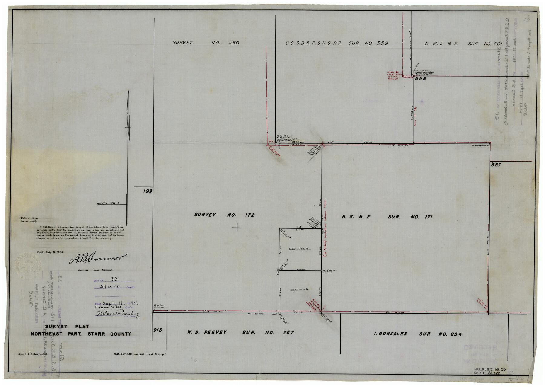
Starr County Rolled Sketch 33
Survey plat, northeast part, Starr County
- 
                          Map/Doc7830
- 
                            CollectionGeneral Map Collection
- 
                            Object Dates1944/7/31 (Creation Date)1944/9/11 (File Date)1944/6/29 (Survey Date)
- 
                            People and OrganizationsA.B. Connor (Surveyor/Engineer)
- 
                            CountiesStarr
- 
                            SubjectsSurveying Rolled Sketch
- 
                            Height x Width21.9 x 30.8 inches55.6 x 78.2 cm
- 
                            Mediumlinen, manuscript
- 
                            Scale1" = 200 varas
Related maps
            Starr County Sketch File 44


                                            Print $8.00                    
                                             -                         Digital $50.00                                    
                Starr County Sketch File 44
1944
Size 14.1 x 8.8 inches
                                Map/Doc 36995
            Part of: General Map Collection
            Bandera County Rolled Sketch 2


                                            Print $20.00                    
                                             -                         Digital $50.00                                    
                Bandera County Rolled Sketch 2
1945
Size 19.1 x 24.0 inches
                                Map/Doc 5114
            
            [Sketch for Mineral Application 26546 - Sabine River between Hawkins Creek and east boundary line of BBB&C RR Co. Surveys, R. S. Rathke]
            
                                    ![65665, [Sketch for Mineral Application 26546 - Sabine River between Hawkins Creek and east boundary line of BBB&C RR Co. Surveys, R. S. Rathke], General Map Collection](https://historictexasmaps.com/wmedia_w700/maps/65665.tif.jpg) 


    ![65665, [Sketch for Mineral Application 26546 - Sabine River between Hawkins Creek and east boundary line of BBB&C RR Co. Surveys, R. S. Rathke], General Map Collection](https://historictexasmaps.com/wmedia_w700/maps/65665.tif.jpg) 
                                
            
                                            Print $40.00                    
                                             -                         Digital $50.00                                    
                [Sketch for Mineral Application 26546 - Sabine River between Hawkins Creek and east boundary line of BBB&C RR Co. Surveys, R. S. Rathke]
1931
Size 25.5 x 75.1 inches
                                Map/Doc 65665
            
            Newton County Working Sketch 26


                                            Print $20.00                    
                                             -                         Digital $50.00                                    
                Newton County Working Sketch 26
1953
Size 18.3 x 16.4 inches
                                Map/Doc 71272
            
            Clay County Rolled Sketch 4A


                                            Print $20.00                    
                                             -                         Digital $50.00                                    
                Clay County Rolled Sketch 4A
1949
Size 22.0 x 24.0 inches
                                Map/Doc 5498
            
            Martin County


                                            Print $20.00                    
                                             -                         Digital $50.00                                    
                Martin County
1933
Size 38.9 x 34.0 inches
                                Map/Doc 77366
            
            Val Verde County Working Sketch 83


                                            Print $40.00                    
                                             -                         Digital $50.00                                    
                Val Verde County Working Sketch 83
1973
Size 28.7 x 53.6 inches
                                Map/Doc 72218
            
            Flight Mission No. DAG-21K, Frame 43, Matagorda County


                                            Print $20.00                    
                                             -                         Digital $50.00                                    
                Flight Mission No. DAG-21K, Frame 43, Matagorda County
1952
Size 18.9 x 22.6 inches
                                Map/Doc 86410
            
            San Patricio County Sketch File 19


                                            Print $2.00                    
                                    
                San Patricio County Sketch File 19
Size 8.0 x 10.5 inches
                                Map/Doc 36068
            
            Hamilton County Boundary File 3


                                            Print $52.00                    
                                             -                         Digital $50.00                                    
                Hamilton County Boundary File 3
Size 14.2 x 8.8 inches
                                Map/Doc 54197
            
            Comal County Rolled Sketch 4


                                            Print $20.00                    
                                             -                         Digital $50.00                                    
                Comal County Rolled Sketch 4
1981
Size 18.8 x 24.5 inches
                                Map/Doc 5539
            You may also like
            Knox County Rolled Sketch 26


                                            Print $20.00                    
                                             -                         Digital $50.00                                    
                Knox County Rolled Sketch 26
2007
Size 36.8 x 24.7 inches
                                Map/Doc 88822
            
            Midland County Working Sketch 1


                                            Print $20.00                    
                                             -                         Digital $50.00                                    
                Midland County Working Sketch 1
Size 26.8 x 8.7 inches
                                Map/Doc 70981
            
            Montague County Working Sketch 8


                                            Print $20.00                    
                                             -                         Digital $50.00                                    
                Montague County Working Sketch 8
1928
Size 20.9 x 18.9 inches
                                Map/Doc 71074
            
            Town of Wellman Situated on Parts of the Northeast 1/4 and Northwest 1/4 Section 17, Block DD


                                            Print $20.00                    
                                             -                         Digital $50.00                                    
                Town of Wellman Situated on Parts of the Northeast 1/4 and Northwest 1/4 Section 17, Block DD
1924
Size 14.3 x 12.3 inches
                                Map/Doc 92886
            
            Harris County Sketch File 25


                                            Print $8.00                    
                                             -                         Digital $50.00                                    
                Harris County Sketch File 25
Size 9.0 x 11.8 inches
                                Map/Doc 25389
            
            Copy of connection with surveys of Bl. D, GH&SA Ry. Co. in Kimble County


                                            Print $6.00                    
                                             -                         Digital $50.00                                    
                Copy of connection with surveys of Bl. D, GH&SA Ry. Co. in Kimble County
1890
Size 14.2 x 8.9 inches
                                Map/Doc 89457
            
            Sketch from Dawson, Martin and Gaines Co's. (a part of Andrews Co. added)


                                            Print $40.00                    
                                             -                         Digital $50.00                                    
                Sketch from Dawson, Martin and Gaines Co's. (a part of Andrews Co. added)
1900
Size 45.0 x 50.6 inches
                                Map/Doc 89781
            
            Red River County Working Sketch 10


                                            Print $20.00                    
                                             -                         Digital $50.00                                    
                Red River County Working Sketch 10
1920
Size 19.1 x 18.8 inches
                                Map/Doc 71993
            
            Webb County Working Sketch 60


                                            Print $20.00                    
                                             -                         Digital $50.00                                    
                Webb County Working Sketch 60
1960
Size 43.3 x 47.8 inches
                                Map/Doc 72426
            
            Tom Green County Rolled Sketch 20


                                            Print $20.00                    
                                             -                         Digital $50.00                                    
                Tom Green County Rolled Sketch 20
Size 20.7 x 13.3 inches
                                Map/Doc 8003
            
            Martin County, Texas


                                            Print $20.00                    
                                             -                         Digital $50.00                                    
                Martin County, Texas
1870
Size 22.9 x 18.0 inches
                                Map/Doc 391
            
            Webb County Sketch File 50-1


                                            Print $8.00                    
                                             -                         Digital $50.00                                    
                Webb County Sketch File 50-1
1943
Size 14.5 x 8.9 inches
                                Map/Doc 39833
             
                         
                                