Zapata County Boundary File 2
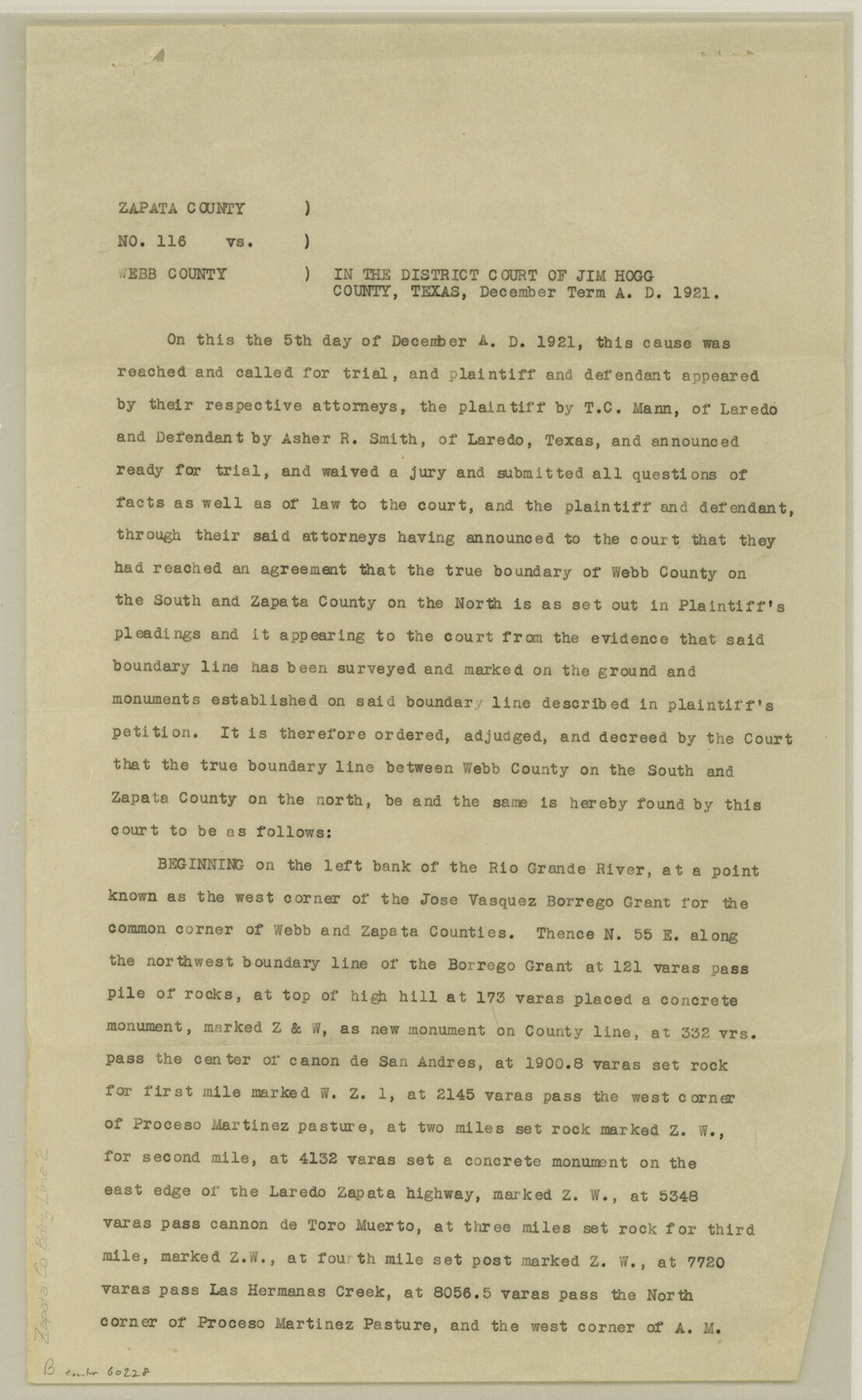
[Judgement, Cause No. 116, Zapata County vs. Webb County]
-
Map/Doc
60228
-
Collection
General Map Collection
-
Counties
Zapata
-
Subjects
County Boundaries
-
Height x Width
14.4 x 8.8 inches
36.6 x 22.4 cm
Part of: General Map Collection
Leon County Rolled Sketch 18

Print $20.00
- Digital $50.00
Leon County Rolled Sketch 18
1982
Size 33.1 x 34.8 inches
Map/Doc 6604
Hutchinson County Working Sketch 26

Print $20.00
- Digital $50.00
Hutchinson County Working Sketch 26
1978
Size 27.5 x 23.4 inches
Map/Doc 66386
Polk County Working Sketch 31

Print $20.00
- Digital $50.00
Polk County Working Sketch 31
1960
Size 18.2 x 24.4 inches
Map/Doc 71647
Ward County Working Sketch 37

Print $20.00
- Digital $50.00
Ward County Working Sketch 37
1969
Size 31.3 x 46.9 inches
Map/Doc 72343
Flight Mission No. DCL-5C, Frame 65, Kenedy County

Print $20.00
- Digital $50.00
Flight Mission No. DCL-5C, Frame 65, Kenedy County
1943
Size 17.9 x 22.4 inches
Map/Doc 85848
Jefferson County Rolled Sketch 31

Print $425.00
- Digital $50.00
Jefferson County Rolled Sketch 31
1955
Size 10.1 x 15.3 inches
Map/Doc 46323

Engineer's Office, Department of the Gulf Map No. 59, Texas prepared by order of Maj. Gen. N. P. Banks under direction of Capt. P. C. Hains, U. S. Engr. & Chief Engr., Dept. of the Gulf

Print $20.00
- Digital $50.00
Engineer's Office, Department of the Gulf Map No. 59, Texas prepared by order of Maj. Gen. N. P. Banks under direction of Capt. P. C. Hains, U. S. Engr. & Chief Engr., Dept. of the Gulf
1865
Size 18.2 x 27.5 inches
Map/Doc 72718
Montague County Sketch File 4

Print $22.00
- Digital $50.00
Montague County Sketch File 4
1855
Size 12.7 x 16.1 inches
Map/Doc 31715
Presidio County Sketch File 92

Print $10.00
- Digital $50.00
Presidio County Sketch File 92
1958
Size 11.2 x 8.8 inches
Map/Doc 34765
Aransas County Rolled Sketch 4

Print $20.00
- Digital $50.00
Aransas County Rolled Sketch 4
1952
Size 28.9 x 26.4 inches
Map/Doc 77189
Colorado County Sketch File 17

Print $22.00
- Digital $50.00
Colorado County Sketch File 17
Size 8.7 x 7.7 inches
Map/Doc 18949
You may also like
Reeves County Rolled Sketch 33

Print $20.00
- Digital $50.00
Reeves County Rolled Sketch 33
Size 24.2 x 36.5 inches
Map/Doc 7502
Map showing Alamo-Donna Farms, Irrigated Section in Hidalgo County, Texas

Print $20.00
- Digital $50.00
Map showing Alamo-Donna Farms, Irrigated Section in Hidalgo County, Texas
1920
Size 27.5 x 13.3 inches
Map/Doc 95803
Atascosa County Boundary File 7

Print $20.00
- Digital $50.00
Atascosa County Boundary File 7
Size 8.2 x 10.1 inches
Map/Doc 50213
[Northwest Quarter of County]
![91077, [Northwest Quarter of County], Twichell Survey Records](https://historictexasmaps.com/wmedia_w700/maps/91077-1.tif.jpg)
Print $20.00
- Digital $50.00
[Northwest Quarter of County]
1914
Size 18.6 x 25.7 inches
Map/Doc 91077
Marion County Sketch File 7

Print $40.00
- Digital $50.00
Marion County Sketch File 7
1866
Size 16.2 x 12.0 inches
Map/Doc 30573
Montague County Sketch File 28

Print $4.00
- Digital $50.00
Montague County Sketch File 28
1963
Size 18.7 x 22.6 inches
Map/Doc 12110
Dallas, Texas

Print $20.00
- Digital $50.00
Dallas, Texas
1890
Size 14.8 x 11.7 inches
Map/Doc 94085
Map of Briscoe County

Print $20.00
- Digital $50.00
Map of Briscoe County
1901
Size 41.4 x 38.0 inches
Map/Doc 4893
[Anderson County]
![5051, [Anderson County], General Map Collection](https://historictexasmaps.com/wmedia_w700/maps/5051-GC.tif.jpg)
Print $20.00
- Digital $50.00
[Anderson County]
1848
Size 26.0 x 19.9 inches
Map/Doc 5051
English Field Notes of the Spanish Archives - Book J. Strode

English Field Notes of the Spanish Archives - Book J. Strode
1835
Map/Doc 96549
Haskell County

Print $20.00
- Digital $50.00
Haskell County
1933
Size 41.7 x 36.2 inches
Map/Doc 77307
The Republic County of Victoria. February 2, 1842

Print $20.00
The Republic County of Victoria. February 2, 1842
2020
Size 24.3 x 21.7 inches
Map/Doc 96299