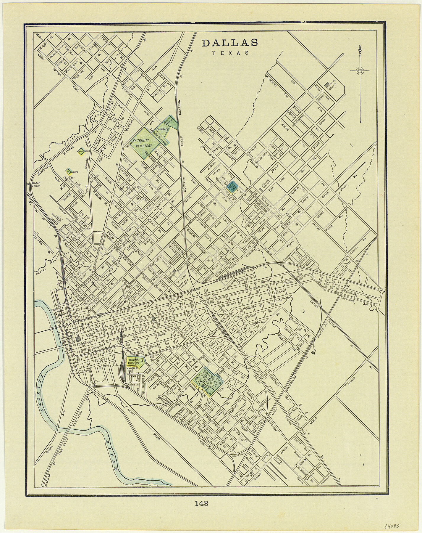
Dallas, Texas
-
Map/Doc
94085
-
Collection
General Map Collection
-
Object Dates
1890 (Creation Date)
-
Counties
Dallas
-
Subjects
City
-
Height x Width
14.8 x 11.7 inches
37.6 x 29.7 cm
-
Medium
paper, etching/engraving/lithograph
-
Comments
See 94086 for a map of San Francisco on verso.
-
Features
Ursuline Convent
Dallas & Oak Cliff Elevated Railroad
City Park
GC&SF
Texas Trunk Railroad
Masonic Cemetery
Dallas Branch [of Trinity River]
T&P
Shadeview Park
Dallas
MK&T
Turtle Creek
Colored Cemetery
Catholic Cemetery
Trinity Cemetery
H&TC
Episcopal College
Related maps

Part of: General Map Collection
Jeff Davis Co.

Print $40.00
- Digital $50.00
Jeff Davis Co.
1915
Size 26.7 x 49.4 inches
Map/Doc 3720
Map of Leon County

Print $40.00
- Digital $50.00
Map of Leon County
Size 49.7 x 42.0 inches
Map/Doc 66900
Flight Mission No. DAG-17K, Frame 72, Matagorda County

Print $20.00
- Digital $50.00
Flight Mission No. DAG-17K, Frame 72, Matagorda County
1952
Size 18.6 x 22.4 inches
Map/Doc 86331
Castro County Sketch File 16

Print $4.00
- Digital $50.00
Castro County Sketch File 16
1891
Size 11.0 x 8.8 inches
Map/Doc 17513
Upton County Sketch File 8

Print $4.00
- Digital $50.00
Upton County Sketch File 8
1913
Size 14.4 x 8.8 inches
Map/Doc 38822
Andrews County Working Sketch 28

Print $20.00
- Digital $50.00
Andrews County Working Sketch 28
Size 32.2 x 35.6 inches
Map/Doc 67074
Harrison County

Print $20.00
- Digital $50.00
Harrison County
1857
Size 20.3 x 21.0 inches
Map/Doc 1116
Briscoe County

Print $20.00
- Digital $50.00
Briscoe County
1930
Size 42.0 x 35.8 inches
Map/Doc 73090
Corrected Map of T&P Ry. surveys in counties Pecos-Presidio-El Paso

Print $20.00
- Digital $50.00
Corrected Map of T&P Ry. surveys in counties Pecos-Presidio-El Paso
1884
Size 27.9 x 39.0 inches
Map/Doc 2301
Harris County Sketch File 18

Print $6.00
- Digital $50.00
Harris County Sketch File 18
1860
Size 8.0 x 3.4 inches
Map/Doc 25363
Sutton County Sketch File 23

Print $30.00
- Digital $50.00
Sutton County Sketch File 23
1918
Size 14.2 x 8.5 inches
Map/Doc 37461
Polk County Sketch File 28

Print $4.00
- Digital $50.00
Polk County Sketch File 28
Size 8.6 x 9.9 inches
Map/Doc 34198
You may also like
Morris County Rolled Sketch 2A

Print $3.00
- Digital $50.00
Morris County Rolled Sketch 2A
Size 12.1 x 10.5 inches
Map/Doc 10233
Correct Map of Texas

Print $20.00
- Digital $50.00
Correct Map of Texas
1904
Size 17.9 x 22.3 inches
Map/Doc 95768
New Map of the State of Texas Compiled from J. De Cordova's large Map

Print $20.00
- Digital $50.00
New Map of the State of Texas Compiled from J. De Cordova's large Map
1856
Size 17.5 x 27.0 inches
Map/Doc 76172
Crosby County Sketch File 3

Print $36.00
- Digital $50.00
Crosby County Sketch File 3
1885
Size 12.8 x 8.7 inches
Map/Doc 19992
Jefferson County Rolled Sketch 26

Print $40.00
- Digital $50.00
Jefferson County Rolled Sketch 26
Size 28.4 x 56.4 inches
Map/Doc 9291
Upton County Rolled Sketch 59

Print $40.00
- Digital $50.00
Upton County Rolled Sketch 59
1994
Size 36.3 x 49.0 inches
Map/Doc 10638
Hansford County Sketch File 10

Print $6.00
- Digital $50.00
Hansford County Sketch File 10
1931
Size 8.2 x 8.5 inches
Map/Doc 24969

Historical Sketch of the Rebellion

Print $20.00
- Digital $50.00
Historical Sketch of the Rebellion
1863
Size 22.4 x 21.0 inches
Map/Doc 96618
Panola County Sketch File 14

Print $4.00
- Digital $50.00
Panola County Sketch File 14
1873
Size 12.2 x 5.2 inches
Map/Doc 33472
Leon County Rolled Sketch 30

Print $20.00
- Digital $50.00
Leon County Rolled Sketch 30
Size 30.9 x 25.7 inches
Map/Doc 6613
Edwards County Working Sketch 24

Print $20.00
- Digital $50.00
Edwards County Working Sketch 24
1942
Size 19.1 x 34.1 inches
Map/Doc 68900