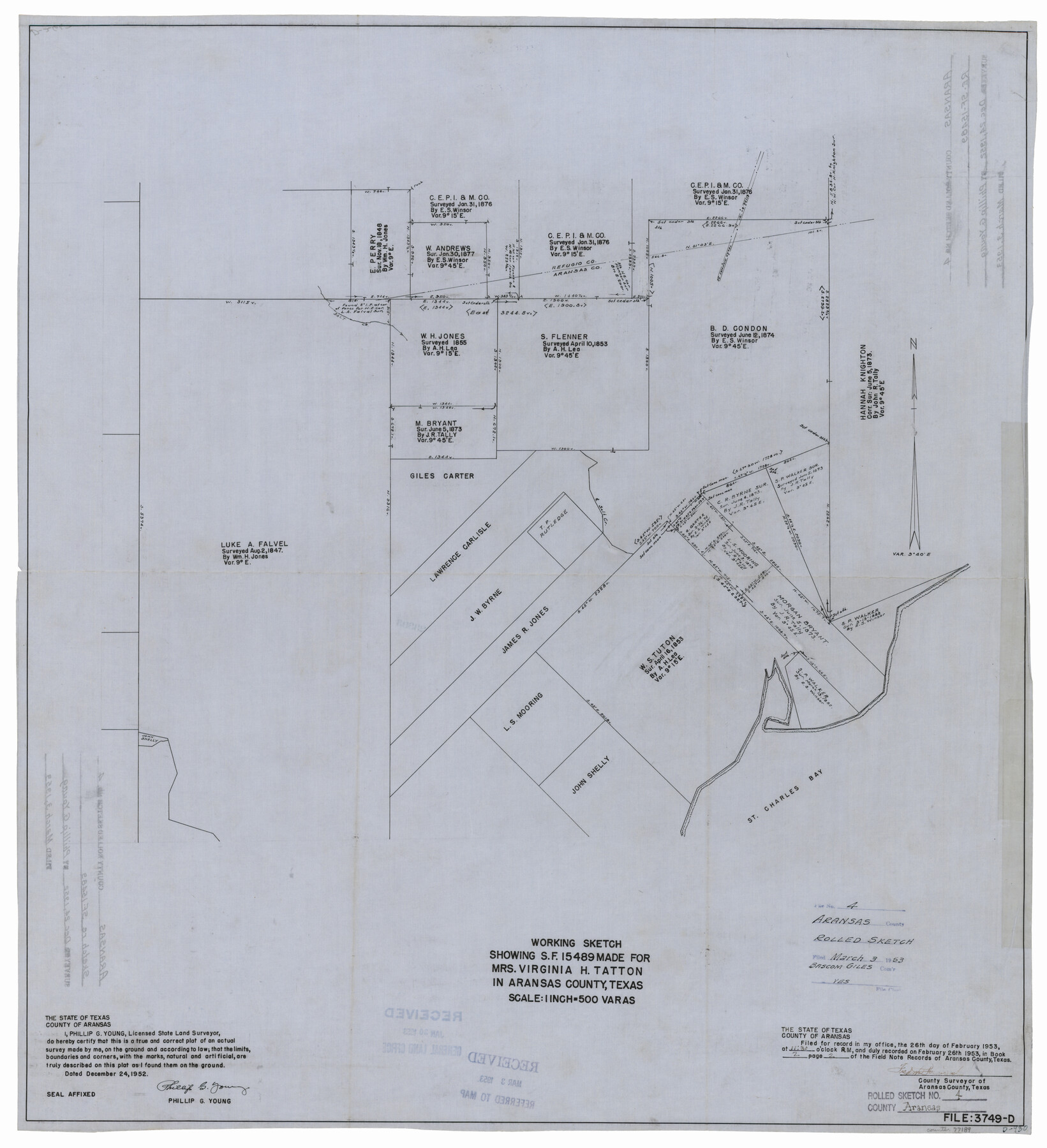
Aransas County Rolled Sketch 4
Working Sketch showing S.F. 15489 made for Mrs. Virginia H. Tatton in Aransas County, Texas
-
Map/Doc
77189
-
Collection
General Map Collection
-
Object Dates
1952/12/24 (Creation Date)
1953/3/3 (File Date)
-
People and Organizations
Phillip G. Young (Surveyor/Engineer)
-
Counties
Aransas
-
Subjects
Surveying Rolled Sketch
-
Height x Width
28.9 x 26.4 inches
73.4 x 67.1 cm
-
Scale
1" = 500 varas
Part of: General Map Collection
Marion County Rolled Sketch 9B

Print $20.00
- Digital $50.00
Marion County Rolled Sketch 9B
2001
Size 22.5 x 22.4 inches
Map/Doc 76420
Gregg County Working Sketch 22

Print $20.00
- Digital $50.00
Gregg County Working Sketch 22
1981
Size 23.2 x 21.5 inches
Map/Doc 63289
Culberson County Working Sketch 20

Print $40.00
- Digital $50.00
Culberson County Working Sketch 20
1935
Size 76.6 x 44.3 inches
Map/Doc 68472
Galveston County Rolled Sketch S

Print $20.00
- Digital $50.00
Galveston County Rolled Sketch S
1935
Size 36.0 x 46.8 inches
Map/Doc 9088
Cherokee County Sketch File 14

Print $4.00
- Digital $50.00
Cherokee County Sketch File 14
1860
Size 8.0 x 5.9 inches
Map/Doc 18147
Louisiana and Texas Intracoastal Waterway

Print $20.00
- Digital $50.00
Louisiana and Texas Intracoastal Waterway
1939
Size 14.0 x 19.6 inches
Map/Doc 83346
Grayson County Sketch File 11

Print $4.00
- Digital $50.00
Grayson County Sketch File 11
1857
Size 13.0 x 8.0 inches
Map/Doc 24476
Medina County Rolled Sketch 21

Print $20.00
- Digital $50.00
Medina County Rolled Sketch 21
2002
Size 33.5 x 19.1 inches
Map/Doc 76412
Edwards County Working Sketch 70

Print $20.00
- Digital $50.00
Edwards County Working Sketch 70
1957
Size 22.5 x 22.4 inches
Map/Doc 68946
Crosby County Sketch File 11a

Print $10.00
- Digital $50.00
Crosby County Sketch File 11a
1894
Size 8.7 x 4.4 inches
Map/Doc 20029
Map of Chambers County

Print $20.00
- Digital $50.00
Map of Chambers County
1896
Size 22.2 x 23.3 inches
Map/Doc 3385
Culberson County Working Sketch 7

Print $20.00
- Digital $50.00
Culberson County Working Sketch 7
1912
Size 21.2 x 17.7 inches
Map/Doc 68459
You may also like
Dickens County Sketch File 1

Print $20.00
- Digital $50.00
Dickens County Sketch File 1
1879
Size 18.2 x 15.5 inches
Map/Doc 11315
Flight Mission No. DAG-21K, Frame 31, Matagorda County

Print $20.00
- Digital $50.00
Flight Mission No. DAG-21K, Frame 31, Matagorda County
1952
Size 18.7 x 22.4 inches
Map/Doc 86398
Gillespie County Working Sketch 13

Print $20.00
- Digital $50.00
Gillespie County Working Sketch 13
2008
Size 22.8 x 31.8 inches
Map/Doc 88831
[Sections 58 through 95]
![92478, [Sections 58 through 95], Twichell Survey Records](https://historictexasmaps.com/wmedia_w700/maps/92478-1.tif.jpg)
Print $20.00
- Digital $50.00
[Sections 58 through 95]
Size 23.9 x 19.5 inches
Map/Doc 92478
Map of the lower surveys in Robertsons Colony Sold by the State of Coahuila and Texas

Print $20.00
- Digital $50.00
Map of the lower surveys in Robertsons Colony Sold by the State of Coahuila and Texas
1834
Size 22.0 x 28.5 inches
Map/Doc 122
Township No. 6 South Range No. 8 West of the Indian Meridian

Print $20.00
- Digital $50.00
Township No. 6 South Range No. 8 West of the Indian Meridian
1874
Size 19.2 x 24.4 inches
Map/Doc 75155
Revised Map of Jefferson County Texas

Print $20.00
- Digital $50.00
Revised Map of Jefferson County Texas
1898
Size 30.1 x 24.5 inches
Map/Doc 78177

Flight Mission No. BQY-4M, Frame 39, Harris County

Print $20.00
- Digital $50.00
Flight Mission No. BQY-4M, Frame 39, Harris County
1953
Size 18.6 x 22.3 inches
Map/Doc 85254
Map of the Fort Worth & Denver City Railway

Print $40.00
- Digital $50.00
Map of the Fort Worth & Denver City Railway
1887
Size 22.8 x 124.4 inches
Map/Doc 64458
Maps & Lists Showing Prison Lands (Oil & Gas) Leased as of June 1955

Digital $50.00
Maps & Lists Showing Prison Lands (Oil & Gas) Leased as of June 1955
1934
Size 29.6 x 38.1 inches
Map/Doc 62880
[Surveying Sketch of H. & T. C. R.R. Co. surveys, et al, unknown county]
![75988, [Surveying Sketch of H. & T. C. R.R. Co. surveys, et al, unknown county], Maddox Collection](https://historictexasmaps.com/wmedia_w700/maps/75988.tif.jpg)
Print $20.00
- Digital $50.00
[Surveying Sketch of H. & T. C. R.R. Co. surveys, et al, unknown county]
Size 21.0 x 25.7 inches
Map/Doc 75988