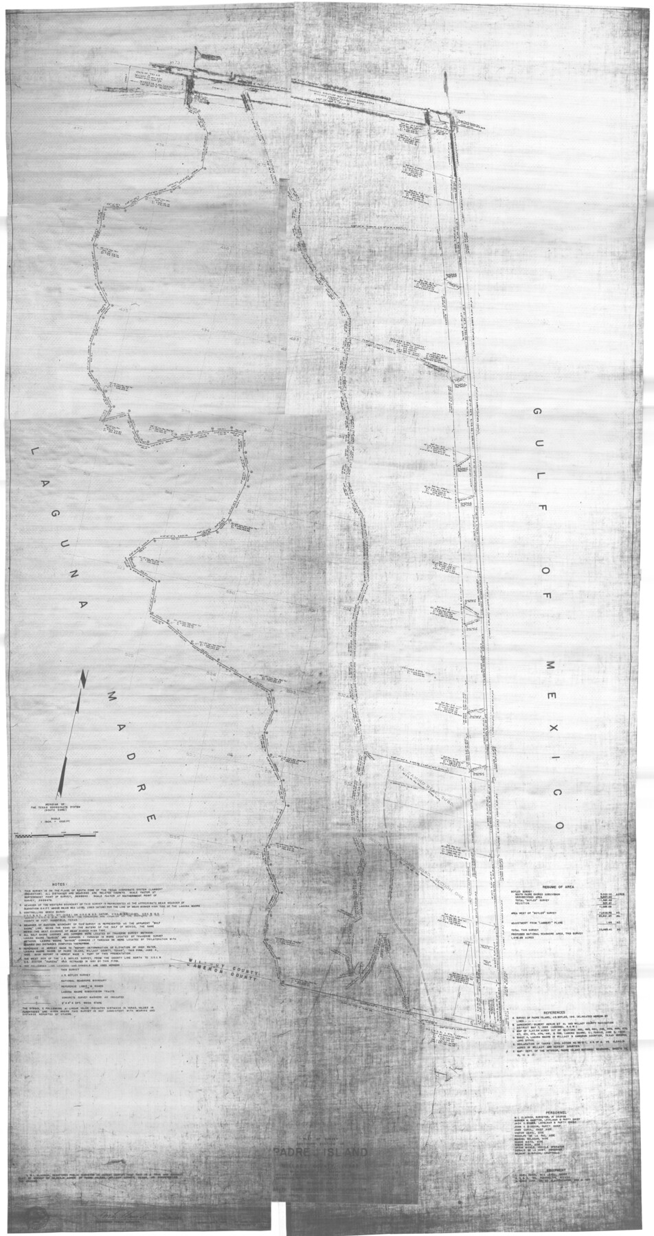
Plat of a survey on Padre Island in Willacy County surveyed for South Padre Development Corporation by Settles and Claunch
-
Map/Doc
61427
-
Collection
General Map Collection
-
Object Dates
1966 (Creation Date)
-
Counties
Willacy
-
Height x Width
78.6 x 41.6 inches
199.6 x 105.7 cm
Part of: General Map Collection
Gaines County Working Sketch 16

Print $20.00
- Digital $50.00
Gaines County Working Sketch 16
1959
Size 42.4 x 37.3 inches
Map/Doc 69316
Live Oak County Working Sketch 20

Print $20.00
- Digital $50.00
Live Oak County Working Sketch 20
1962
Size 29.7 x 35.7 inches
Map/Doc 70605
Kenedy County Sketch File 2

Print $130.00
- Digital $50.00
Kenedy County Sketch File 2
1995
Size 11.2 x 8.7 inches
Map/Doc 28773
Old Miscellaneous File 16

Print $28.00
- Digital $50.00
Old Miscellaneous File 16
1908
Size 9.8 x 2.6 inches
Map/Doc 75457
Dawson County Working Sketch 15

Print $20.00
- Digital $50.00
Dawson County Working Sketch 15
1955
Size 28.2 x 24.8 inches
Map/Doc 68559
Shackelford County Sketch File 2

Print $4.00
- Digital $50.00
Shackelford County Sketch File 2
1870
Size 9.3 x 9.0 inches
Map/Doc 36572
Taylor County Working Sketch 14

Print $20.00
- Digital $50.00
Taylor County Working Sketch 14
1959
Size 26.8 x 21.4 inches
Map/Doc 69624
Jeff Davis County Sketch File 22

Print $20.00
- Digital $50.00
Jeff Davis County Sketch File 22
1923
Size 19.4 x 25.0 inches
Map/Doc 11860
Liberty County Sketch File 32a

Print $4.00
- Digital $50.00
Liberty County Sketch File 32a
Size 9.2 x 7.6 inches
Map/Doc 29965
Johnson County Sketch File 11

Print $8.00
- Digital $50.00
Johnson County Sketch File 11
1880
Size 8.0 x 6.8 inches
Map/Doc 28447
Edwards County Sketch File 27

Print $6.00
- Digital $50.00
Edwards County Sketch File 27
1913
Size 10.5 x 16.5 inches
Map/Doc 21755
Kendall County Working Sketch 16

Print $20.00
- Digital $50.00
Kendall County Working Sketch 16
1967
Size 28.0 x 29.1 inches
Map/Doc 66688
You may also like
Hale County Working Sketch 1

Print $20.00
- Digital $50.00
Hale County Working Sketch 1
1910
Size 34.5 x 22.1 inches
Map/Doc 63321
Madison County Working Sketch 10

Print $20.00
- Digital $50.00
Madison County Working Sketch 10
1960
Size 34.7 x 32.0 inches
Map/Doc 70772
Atascosa County Rolled Sketch 17

Print $20.00
- Digital $50.00
Atascosa County Rolled Sketch 17
1953
Size 35.6 x 28.2 inches
Map/Doc 5097
Marion County Sketch File 14

Print $20.00
- Digital $50.00
Marion County Sketch File 14
Size 26.6 x 17.1 inches
Map/Doc 12024
Burnet County Sketch File 1

Print $40.00
- Digital $50.00
Burnet County Sketch File 1
1847
Size 16.1 x 12.4 inches
Map/Doc 16670
Zavala County Sketch File 7

Print $6.00
- Digital $50.00
Zavala County Sketch File 7
Size 9.4 x 16.3 inches
Map/Doc 41265
The MKT - Texas Empire of the South

Print $20.00
- Digital $50.00
The MKT - Texas Empire of the South
1905
Size 18.5 x 40.6 inches
Map/Doc 97035
Duval County Working Sketch 30

Print $20.00
- Digital $50.00
Duval County Working Sketch 30
1950
Size 29.1 x 33.5 inches
Map/Doc 68754
Bandera County Working Sketch 20

Print $20.00
- Digital $50.00
Bandera County Working Sketch 20
1947
Size 25.4 x 19.8 inches
Map/Doc 67616
Brazoria County Sketch File 49

Print $20.00
- Digital $50.00
Brazoria County Sketch File 49
Size 14.2 x 8.7 inches
Map/Doc 15112
General Highway Map, Throckmorton County, Texas

Print $20.00
General Highway Map, Throckmorton County, Texas
1961
Size 18.2 x 24.8 inches
Map/Doc 79676
Jarrott Ranch Yeso, New Mexico

Print $20.00
- Digital $50.00
Jarrott Ranch Yeso, New Mexico
Size 26.3 x 19.8 inches
Map/Doc 92423