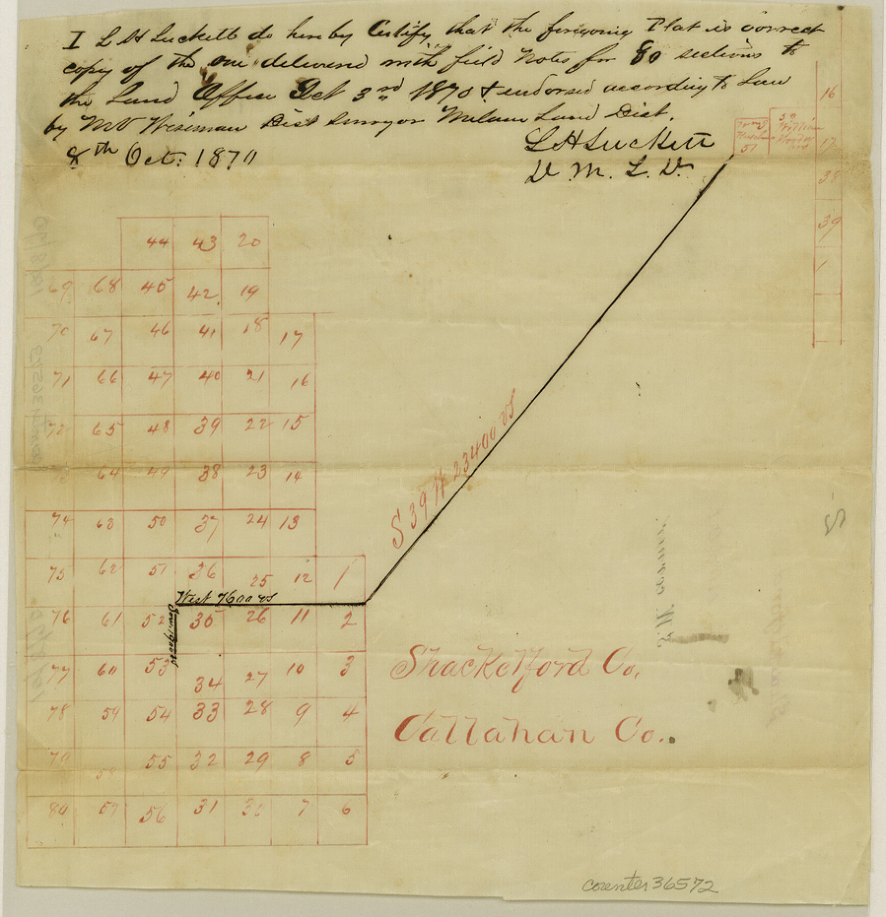
Shackelford County Sketch File 2
[Sketch in southwest portion of county]
-
Map/Doc
36572
-
Collection
General Map Collection
-
Object Dates
10/8/1870 (Creation Date)
-
Counties
Shackelford Callahan
-
Subjects
Surveying Sketch File
-
Height x Width
9.3 x 9.0 inches
23.6 x 22.9 cm
-
Medium
paper, manuscript
Part of: General Map Collection
Nueces County NRC Article 33.136 Sketch 17

Print $26.00
- Digital $50.00
Nueces County NRC Article 33.136 Sketch 17
2013
Size 18.0 x 24.0 inches
Map/Doc 94487
Map of Henderson County

Print $20.00
- Digital $50.00
Map of Henderson County
1871
Size 16.3 x 30.3 inches
Map/Doc 4563
Glasscock County Working Sketch 6

Print $20.00
- Digital $50.00
Glasscock County Working Sketch 6
1945
Size 22.0 x 22.9 inches
Map/Doc 63179
Right of Way and Track Map, the Missouri, Kansas and Texas Ry. of Texas operated by the Missouri, Kansas and Texas Ry. of Texas, San Antonio Division

Print $40.00
- Digital $50.00
Right of Way and Track Map, the Missouri, Kansas and Texas Ry. of Texas operated by the Missouri, Kansas and Texas Ry. of Texas, San Antonio Division
1918
Size 25.6 x 57.8 inches
Map/Doc 64582
Callahan County Working Sketch 6

Print $20.00
- Digital $50.00
Callahan County Working Sketch 6
1955
Size 30.2 x 18.8 inches
Map/Doc 67888
Val Verde County Rolled Sketch 67

Print $20.00
- Digital $50.00
Val Verde County Rolled Sketch 67
1958
Size 24.5 x 31.6 inches
Map/Doc 8130
Jim Hogg County Boundary File 2

Print $4.00
- Digital $50.00
Jim Hogg County Boundary File 2
Size 10.6 x 8.7 inches
Map/Doc 55527

Outer Continental Shelf Leasing Maps (Texas Offshore Operations)

Print $20.00
- Digital $50.00
Outer Continental Shelf Leasing Maps (Texas Offshore Operations)
Size 18.0 x 13.9 inches
Map/Doc 75852
Zavala County

Print $40.00
- Digital $50.00
Zavala County
1977
Size 43.6 x 49.3 inches
Map/Doc 95684
Sutton County Boundary File 4

Print $20.00
- Digital $50.00
Sutton County Boundary File 4
Size 14.2 x 8.8 inches
Map/Doc 59035
Montgomery County Sketch File 2

Print $8.00
- Digital $50.00
Montgomery County Sketch File 2
1846
Size 12.7 x 8.0 inches
Map/Doc 31764
You may also like
Fort Bend County Working Sketch 19

Print $20.00
- Digital $50.00
Fort Bend County Working Sketch 19
1959
Size 26.3 x 29.9 inches
Map/Doc 69225
Webb County Rolled Sketch 60

Print $20.00
- Digital $50.00
Webb County Rolled Sketch 60
1947
Size 30.0 x 33.8 inches
Map/Doc 8211
McLennan County Sketch File 22

Print $3.00
- Digital $50.00
McLennan County Sketch File 22
1869
Size 11.1 x 9.3 inches
Map/Doc 31296
[Sketch for Mineral Application 24072, San Jacinto River]
![65606, [Sketch for Mineral Application 24072, San Jacinto River], General Map Collection](https://historictexasmaps.com/wmedia_w700/maps/65606.tif.jpg)
Print $20.00
- Digital $50.00
[Sketch for Mineral Application 24072, San Jacinto River]
1929
Size 23.2 x 17.8 inches
Map/Doc 65606
Pecos County Rolled Sketch 77

Print $20.00
- Digital $50.00
Pecos County Rolled Sketch 77
1930
Size 38.4 x 23.4 inches
Map/Doc 7238
Bastrop County Working Sketch 7

Print $20.00
- Digital $50.00
Bastrop County Working Sketch 7
1930
Size 32.7 x 29.7 inches
Map/Doc 67307

Webb County Rolled Sketch 28

Print $20.00
- Digital $50.00
Webb County Rolled Sketch 28
1932
Size 27.5 x 20.6 inches
Map/Doc 8186
Howard County Working Sketch 7a

Print $40.00
- Digital $50.00
Howard County Working Sketch 7a
1950
Size 81.9 x 24.7 inches
Map/Doc 66273
Tom Green Co.

Print $40.00
- Digital $50.00
Tom Green Co.
1887
Size 42.0 x 110.7 inches
Map/Doc 76034
From Citizens of Fannin County for the Creation of a New County to be Called Sherman, December 1, 1845

Print $20.00
From Citizens of Fannin County for the Creation of a New County to be Called Sherman, December 1, 1845
2020
Size 16.7 x 21.7 inches
Map/Doc 96397
Texas City. First and Second Division

Print $20.00
- Digital $50.00
Texas City. First and Second Division
1892
Size 24.3 x 19.1 inches
Map/Doc 95355