[Titles along the Trinity River]
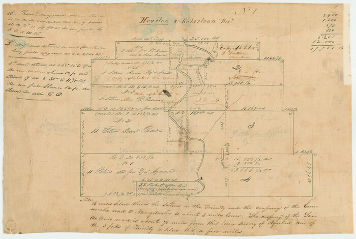
Print $3.00
- Digital $50.00
[Titles along the Trinity River]
Size: 10.6 x 15.8 inches
175
[Victor Blanco's survey along the San Antonio River]
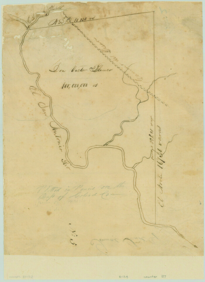
Print $2.00
- Digital $50.00
[Victor Blanco's survey along the San Antonio River]
Size: 11.2 x 8.2 inches
187
Water-Shed of the Pease River Drainage Area

Print $6.00
- Digital $50.00
Water-Shed of the Pease River Drainage Area
Size: 14.9 x 31.0 inches
65102
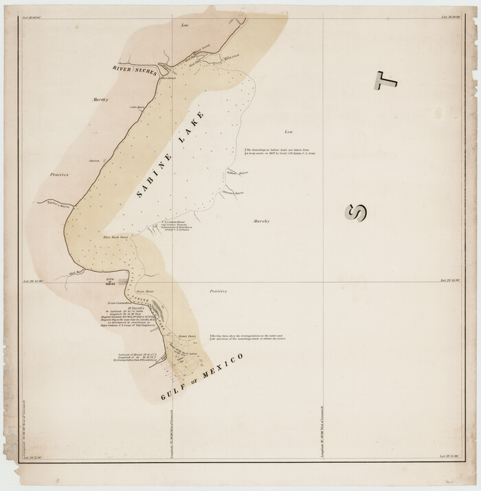
Sabine River, Watershed of the Sabine and Neches Rivers

Print $20.00
- Digital $50.00
Sabine River, Watershed of the Sabine and Neches Rivers
Size: 39.5 x 36.0 inches
65132
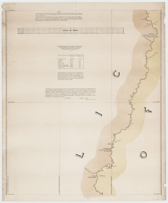
Sabine River, Composite Sheet

Print $40.00
- Digital $50.00
Sabine River, Composite Sheet
Size: 38.5 x 52.7 inches
65133
Sabine River, Rocky Point Crossing Sheet

Print $4.00
- Digital $50.00
Sabine River, Rocky Point Crossing Sheet
Size: 24.0 x 24.6 inches
65134
Sabine River, Kane Bridge Sheet

Print $4.00
- Digital $50.00
Sabine River, Kane Bridge Sheet
Size: 20.9 x 24.2 inches
65135
San Jacinto River, Water Sheds of the San Jacinto River and Buffalo Bayou

Print $4.00
- Digital $50.00
San Jacinto River, Water Sheds of the San Jacinto River and Buffalo Bayou
Size: 28.8 x 20.0 inches
65149
Drainage Basins of Texas Streams

Print $20.00
- Digital $50.00
Drainage Basins of Texas Streams
Size: 17.0 x 19.3 inches
65269
Drainage Basins of Texas Streams

Print $20.00
- Digital $50.00
Drainage Basins of Texas Streams
Size: 35.3 x 42.0 inches
65270
No. 1. Outline Map of the Rio Grande from its mouth up to Ringold Barracks

Print $20.00
- Digital $50.00
No. 1. Outline Map of the Rio Grande from its mouth up to Ringold Barracks
Size: 24.8 x 18.3 inches
72857
No. 1. Outline Map of the Rio Grande from its mouth up to Ringold Barracks

Print $20.00
- Digital $50.00
No. 1. Outline Map of the Rio Grande from its mouth up to Ringold Barracks
Size: 24.5 x 18.3 inches
72858
Sketch exhibiting the San Antonio River from the source to the fork of Goliad

Print $20.00
- Digital $50.00
Sketch exhibiting the San Antonio River from the source to the fork of Goliad
Size: 27.5 x 16.6 inches
73009
Current Miscellaneous File 6

Print $4.00
- Digital $50.00
Current Miscellaneous File 6
Size: 11.3 x 8.8 inches
73731
Current Miscellaneous File 112

Print $138.00
- Digital $50.00
Current Miscellaneous File 112
Size: 11.3 x 8.7 inches
74718
Sulphur River, Bexelder Sheet/Cuthand Creek

Print $20.00
- Digital $50.00
Sulphur River, Bexelder Sheet/Cuthand Creek
Size: 17.3 x 14.1 inches
78325
Map of the River Sabine from Logan's Ferry to 32nd degree of North Latitude

Print $20.00
- Digital $50.00
Map of the River Sabine from Logan's Ferry to 32nd degree of North Latitude
Size: 22.1 x 28.6 inches
94002
[Map of the River Sabine from its mouth on the Gulf of Mexico in the sea to Logan's Ferry in Latitude 31° 58' 24" North]
Print $20.00
- Digital $50.00
[Map of the River Sabine from its mouth on the Gulf of Mexico in the sea to Logan's Ferry in Latitude 31° 58' 24" North]
Size: 31.5 x 31.3 inches
94005
[Map of the River Sabine from its mouth on the Gulf of Mexico in the sea to Logan's Ferry in Latitude 31° 58' 24" North]
Print $20.00
- Digital $50.00
[Map of the River Sabine from its mouth on the Gulf of Mexico in the sea to Logan's Ferry in Latitude 31° 58' 24" North]
Size: 37.7 x 31.6 inches
94006
Chocolate Bayou, Texas showing proposed connection from its mouth to West Galveston Bay for a Light Draft Navigation

Print $20.00
- Digital $50.00
Chocolate Bayou, Texas showing proposed connection from its mouth to West Galveston Bay for a Light Draft Navigation
Size: 13.2 x 20.4 inches
96557
Reconnaissance for Triangulation along the Rio Grande from El Paso to the Gulf of Mexico

Print $20.00
- Digital $50.00
Reconnaissance for Triangulation along the Rio Grande from El Paso to the Gulf of Mexico
Size: 16.9 x 22.6 inches
96558
San Bernard River, Texas showing possible connection with Brazos River and part of possible connection with Matagorda Bay for a Light Draft Navigation

Print $40.00
- Digital $50.00
San Bernard River, Texas showing possible connection with Brazos River and part of possible connection with Matagorda Bay for a Light Draft Navigation
Size: 17.2 x 56.1 inches
96561
Oyster Creek, Texas showing connection with Brazos River & Oyster Bay by the Galveston & Brazos Canal for a Light Draft Navigation

Print $40.00
- Digital $50.00
Oyster Creek, Texas showing connection with Brazos River & Oyster Bay by the Galveston & Brazos Canal for a Light Draft Navigation
Size: 18.0 x 52.9 inches
96562
Guadalupe-Blanco River Authority Master Plan

Print $20.00
Guadalupe-Blanco River Authority Master Plan
Size: 23.1 x 29.8 inches
97506
Le Cours de Fleuve Missisipi, selon les relations les plus modernes

Print $20.00
- Digital $50.00
Le Cours de Fleuve Missisipi, selon les relations les plus modernes
1737
Size: 16.4 x 19.3 inches
94001
Old Miscellaneous File 2

Print $16.00
- Digital $50.00
Old Miscellaneous File 2
1838
Size: 13.0 x 8.0 inches
75406
Sabine Pass and mouth of the River Sabine

Print $20.00
- Digital $50.00
Sabine Pass and mouth of the River Sabine
1840
Size: 27.0 x 18.3 inches
72726
Map of the River Sabine from its Mouth on the Gulf of Mexico in the Sea to Logan's Ferry in Latitude 31° 58' 25" North

Print $20.00
Map of the River Sabine from its Mouth on the Gulf of Mexico in the Sea to Logan's Ferry in Latitude 31° 58' 25" North
1840
Size: 35.5 x 9.1 inches
79294
Map of the River Sabine from its Mouth on the Gulf of Mexico in the Sea to Logan's Ferry in Latitude 31°58'24" north

Print $40.00
Map of the River Sabine from its Mouth on the Gulf of Mexico in the Sea to Logan's Ferry in Latitude 31°58'24" north
1840
Size: 35.0 x 170.0 inches
88901
[Titles along the Trinity River]
Print $3.00
- Digital $50.00
[Titles along the Trinity River]
-
Size
10.6 x 15.8 inches
-
Map/Doc
175
[Victor Blanco's survey along the San Antonio River]
Print $2.00
- Digital $50.00
[Victor Blanco's survey along the San Antonio River]
-
Size
11.2 x 8.2 inches
-
Map/Doc
187
[Pecos River Bed]
![2467, [Pecos River Bed], General Map Collection](https://historictexasmaps.com/wmedia_w700/maps/2467.tif.jpg)
Print $20.00
- Digital $50.00
[Pecos River Bed]
-
Size
16.6 x 39.8 inches
-
Map/Doc
2467
Water-Shed of the Pease River Drainage Area
Print $6.00
- Digital $50.00
Water-Shed of the Pease River Drainage Area
-
Size
14.9 x 31.0 inches
-
Map/Doc
65102
Sabine River, Watershed of the Sabine and Neches Rivers
Print $20.00
- Digital $50.00
Sabine River, Watershed of the Sabine and Neches Rivers
-
Size
39.5 x 36.0 inches
-
Map/Doc
65132
Sabine River, Composite Sheet
Print $40.00
- Digital $50.00
Sabine River, Composite Sheet
-
Size
38.5 x 52.7 inches
-
Map/Doc
65133
Sabine River, Rocky Point Crossing Sheet
Print $4.00
- Digital $50.00
Sabine River, Rocky Point Crossing Sheet
-
Size
24.0 x 24.6 inches
-
Map/Doc
65134
Sabine River, Kane Bridge Sheet
Print $4.00
- Digital $50.00
Sabine River, Kane Bridge Sheet
-
Size
20.9 x 24.2 inches
-
Map/Doc
65135
San Jacinto River, Water Sheds of the San Jacinto River and Buffalo Bayou
Print $4.00
- Digital $50.00
San Jacinto River, Water Sheds of the San Jacinto River and Buffalo Bayou
-
Size
28.8 x 20.0 inches
-
Map/Doc
65149
Drainage Basins of Texas Streams
Print $20.00
- Digital $50.00
Drainage Basins of Texas Streams
-
Size
17.0 x 19.3 inches
-
Map/Doc
65269
Drainage Basins of Texas Streams
Print $20.00
- Digital $50.00
Drainage Basins of Texas Streams
-
Size
35.3 x 42.0 inches
-
Map/Doc
65270
No. 1. Outline Map of the Rio Grande from its mouth up to Ringold Barracks
Print $20.00
- Digital $50.00
No. 1. Outline Map of the Rio Grande from its mouth up to Ringold Barracks
-
Size
24.8 x 18.3 inches
-
Map/Doc
72857
No. 1. Outline Map of the Rio Grande from its mouth up to Ringold Barracks
Print $20.00
- Digital $50.00
No. 1. Outline Map of the Rio Grande from its mouth up to Ringold Barracks
-
Size
24.5 x 18.3 inches
-
Map/Doc
72858
Sketch exhibiting the San Antonio River from the source to the fork of Goliad
Print $20.00
- Digital $50.00
Sketch exhibiting the San Antonio River from the source to the fork of Goliad
-
Size
27.5 x 16.6 inches
-
Map/Doc
73009
Current Miscellaneous File 6
Print $4.00
- Digital $50.00
Current Miscellaneous File 6
-
Size
11.3 x 8.8 inches
-
Map/Doc
73731
Current Miscellaneous File 112
Print $138.00
- Digital $50.00
Current Miscellaneous File 112
-
Size
11.3 x 8.7 inches
-
Map/Doc
74718
Sulphur River, Bexelder Sheet/Cuthand Creek
Print $20.00
- Digital $50.00
Sulphur River, Bexelder Sheet/Cuthand Creek
-
Size
17.3 x 14.1 inches
-
Map/Doc
78325
Map of the River Sabine from Logan's Ferry to 32nd degree of North Latitude
Print $20.00
- Digital $50.00
Map of the River Sabine from Logan's Ferry to 32nd degree of North Latitude
-
Size
22.1 x 28.6 inches
-
Map/Doc
94002
[Map of the River Sabine from its mouth on the Gulf of Mexico in the sea to Logan's Ferry in Latitude 31° 58' 24" North]
Print $20.00
- Digital $50.00
[Map of the River Sabine from its mouth on the Gulf of Mexico in the sea to Logan's Ferry in Latitude 31° 58' 24" North]
-
Size
31.5 x 31.3 inches
-
Map/Doc
94005
[Map of the River Sabine from its mouth on the Gulf of Mexico in the sea to Logan's Ferry in Latitude 31° 58' 24" North]
Print $20.00
- Digital $50.00
[Map of the River Sabine from its mouth on the Gulf of Mexico in the sea to Logan's Ferry in Latitude 31° 58' 24" North]
-
Size
37.7 x 31.6 inches
-
Map/Doc
94006
Chocolate Bayou, Texas showing proposed connection from its mouth to West Galveston Bay for a Light Draft Navigation
Print $20.00
- Digital $50.00
Chocolate Bayou, Texas showing proposed connection from its mouth to West Galveston Bay for a Light Draft Navigation
-
Size
13.2 x 20.4 inches
-
Map/Doc
96557
Reconnaissance for Triangulation along the Rio Grande from El Paso to the Gulf of Mexico
Print $20.00
- Digital $50.00
Reconnaissance for Triangulation along the Rio Grande from El Paso to the Gulf of Mexico
-
Size
16.9 x 22.6 inches
-
Map/Doc
96558
San Bernard River, Texas showing possible connection with Brazos River and part of possible connection with Matagorda Bay for a Light Draft Navigation
Print $40.00
- Digital $50.00
San Bernard River, Texas showing possible connection with Brazos River and part of possible connection with Matagorda Bay for a Light Draft Navigation
-
Size
17.2 x 56.1 inches
-
Map/Doc
96561
Oyster Creek, Texas showing connection with Brazos River & Oyster Bay by the Galveston & Brazos Canal for a Light Draft Navigation
Print $40.00
- Digital $50.00
Oyster Creek, Texas showing connection with Brazos River & Oyster Bay by the Galveston & Brazos Canal for a Light Draft Navigation
-
Size
18.0 x 52.9 inches
-
Map/Doc
96562
Guadalupe-Blanco River Authority Master Plan
Print $20.00
Guadalupe-Blanco River Authority Master Plan
-
Size
23.1 x 29.8 inches
-
Map/Doc
97506
Le Cours de Fleuve Missisipi, selon les relations les plus modernes
Print $20.00
- Digital $50.00
Le Cours de Fleuve Missisipi, selon les relations les plus modernes
1737
-
Size
16.4 x 19.3 inches
-
Map/Doc
94001
-
Creation Date
1737
Old Miscellaneous File 2
Print $16.00
- Digital $50.00
Old Miscellaneous File 2
1838
-
Size
13.0 x 8.0 inches
-
Map/Doc
75406
-
Creation Date
1838
Sabine Pass and mouth of the River Sabine
Print $20.00
- Digital $50.00
Sabine Pass and mouth of the River Sabine
1840
-
Size
27.0 x 18.3 inches
-
Map/Doc
72726
-
Creation Date
1840
Map of the River Sabine from its Mouth on the Gulf of Mexico in the Sea to Logan's Ferry in Latitude 31° 58' 25" North
Print $20.00
Map of the River Sabine from its Mouth on the Gulf of Mexico in the Sea to Logan's Ferry in Latitude 31° 58' 25" North
1840
-
Size
35.5 x 9.1 inches
-
Map/Doc
79294
-
Creation Date
1840
Map of the River Sabine from its Mouth on the Gulf of Mexico in the Sea to Logan's Ferry in Latitude 31°58'24" north
Print $40.00
Map of the River Sabine from its Mouth on the Gulf of Mexico in the Sea to Logan's Ferry in Latitude 31°58'24" north
1840
-
Size
35.0 x 170.0 inches
-
Map/Doc
88901
-
Creation Date
1840