Runnels County Sketch File 41
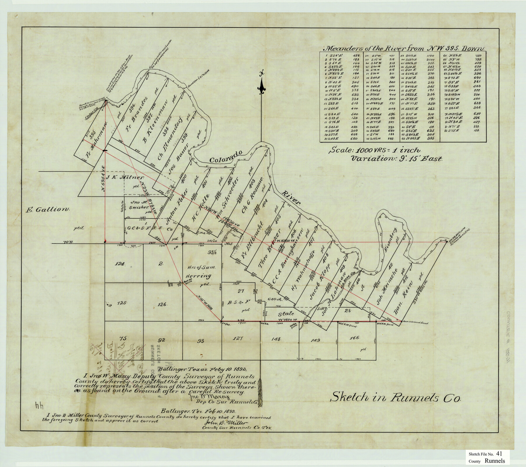
Sketch in Runnels Co. [showing surveys south of the Colorado River in the southwest part of the county]
-
Map/Doc
12271
-
Collection
General Map Collection
-
Object Dates
2/10/1892 (Creation Date)
2/23/1892 (File Date)
-
People and Organizations
Jno. W. Maxcy (Surveyor/Engineer)
-
Counties
Runnels
-
Subjects
Surveying Sketch File
-
Height x Width
22.8 x 25.7 inches
57.9 x 65.3 cm
-
Medium
paper, manuscript
-
Scale
1" = 1000 varas
-
Features
Cedar Creek
Colorado River
Red Bank Creek
Part of: General Map Collection
Webb County Rolled Sketch EF2

Print $20.00
- Digital $50.00
Webb County Rolled Sketch EF2
1932
Size 40.4 x 29.9 inches
Map/Doc 8224
Gregg County Sketch File 13

Print $32.00
- Digital $50.00
Gregg County Sketch File 13
1934
Size 13.9 x 8.7 inches
Map/Doc 24597
Burnet County Boundary File 7a

Print $30.00
- Digital $50.00
Burnet County Boundary File 7a
Size 14.1 x 8.5 inches
Map/Doc 50902
Flight Mission No. BRA-16M, Frame 64, Jefferson County

Print $20.00
- Digital $50.00
Flight Mission No. BRA-16M, Frame 64, Jefferson County
1953
Size 18.8 x 22.3 inches
Map/Doc 85681
Kent County Sketch File 7

Print $20.00
- Digital $50.00
Kent County Sketch File 7
1902
Size 21.7 x 37.6 inches
Map/Doc 10514
Flight Mission No. BRE-1P, Frame 107, Nueces County

Print $20.00
- Digital $50.00
Flight Mission No. BRE-1P, Frame 107, Nueces County
1956
Size 18.5 x 22.6 inches
Map/Doc 86678
Tom Green County Rolled Sketch 28

Print $20.00
- Digital $50.00
Tom Green County Rolled Sketch 28
Size 25.3 x 25.4 inches
Map/Doc 8008
PSL Field Notes for Blocks C36 and C37 in Gaines and Terry Counties, Block C38 in Dawson, Gaines, and Terry Counties, Blocks C39 and C41 in Dawson and Terry Counties, Block K in Yoakum and Terry Counties

PSL Field Notes for Blocks C36 and C37 in Gaines and Terry Counties, Block C38 in Dawson, Gaines, and Terry Counties, Blocks C39 and C41 in Dawson and Terry Counties, Block K in Yoakum and Terry Counties
Map/Doc 81674
Hansford County Boundary File 2b

Print $14.00
- Digital $50.00
Hansford County Boundary File 2b
Size 14.3 x 8.8 inches
Map/Doc 54263
Texas Coordinate File 6

Print $40.00
- Digital $50.00
Texas Coordinate File 6
1946
Size 23.7 x 49.0 inches
Map/Doc 75314
Controlled Mosaic by Jack Amman Photogrammetric Engineers, Inc - Sheet 9

Print $20.00
- Digital $50.00
Controlled Mosaic by Jack Amman Photogrammetric Engineers, Inc - Sheet 9
1954
Size 20.0 x 24.0 inches
Map/Doc 83453
Harris County Rolled Sketch 66

Print $40.00
- Digital $50.00
Harris County Rolled Sketch 66
1940
Size 36.7 x 51.4 inches
Map/Doc 9129
You may also like
Newton County Sketch File 47

Print $20.00
- Digital $50.00
Newton County Sketch File 47
1932
Size 18.9 x 21.9 inches
Map/Doc 42159
[East Portion of Lea County] / [Central part of San Miguel County, New Mexico]
![92033, [East Portion of Lea County] / [Central part of San Miguel County, New Mexico], Twichell Survey Records](https://historictexasmaps.com/wmedia_w700/maps/92033-1.tif.jpg)
Print $20.00
- Digital $50.00
[East Portion of Lea County] / [Central part of San Miguel County, New Mexico]
Size 26.9 x 13.9 inches
Map/Doc 92033
Index for Texas Railroad ROW & track maps available on microfilm at THD & Archives and Records

Print $2.00
- Digital $50.00
Index for Texas Railroad ROW & track maps available on microfilm at THD & Archives and Records
1977
Size 11.1 x 8.7 inches
Map/Doc 60762

[Block O1, Godair]
![90565, [Block O1, Godair], Twichell Survey Records](https://historictexasmaps.com/wmedia_w700/maps/90565-1.tif.jpg)
Print $20.00
- Digital $50.00
[Block O1, Godair]
Size 22.6 x 17.7 inches
Map/Doc 90565
[St. Louis & Southwestern]
![64279, [St. Louis & Southwestern], General Map Collection](https://historictexasmaps.com/wmedia_w700/maps/64279.tif.jpg)
Print $20.00
- Digital $50.00
[St. Louis & Southwestern]
Size 20.7 x 28.5 inches
Map/Doc 64279
Current Miscellaneous File 46

Print $4.00
- Digital $50.00
Current Miscellaneous File 46
1954
Size 10.7 x 8.2 inches
Map/Doc 73990
General Highway Map, Mitchell County, Texas

Print $20.00
General Highway Map, Mitchell County, Texas
1961
Size 18.1 x 24.6 inches
Map/Doc 79600
Cass County Working Sketch 3

Print $20.00
- Digital $50.00
Cass County Working Sketch 3
1936
Size 34.3 x 38.5 inches
Map/Doc 67906
Pecos County Rolled Sketch 163

Print $20.00
- Digital $50.00
Pecos County Rolled Sketch 163
Size 28.2 x 23.9 inches
Map/Doc 7286
Flight Mission No. DAG-26K, Frame 63, Matagorda County

Print $20.00
- Digital $50.00
Flight Mission No. DAG-26K, Frame 63, Matagorda County
1953
Size 18.5 x 22.2 inches
Map/Doc 86583
