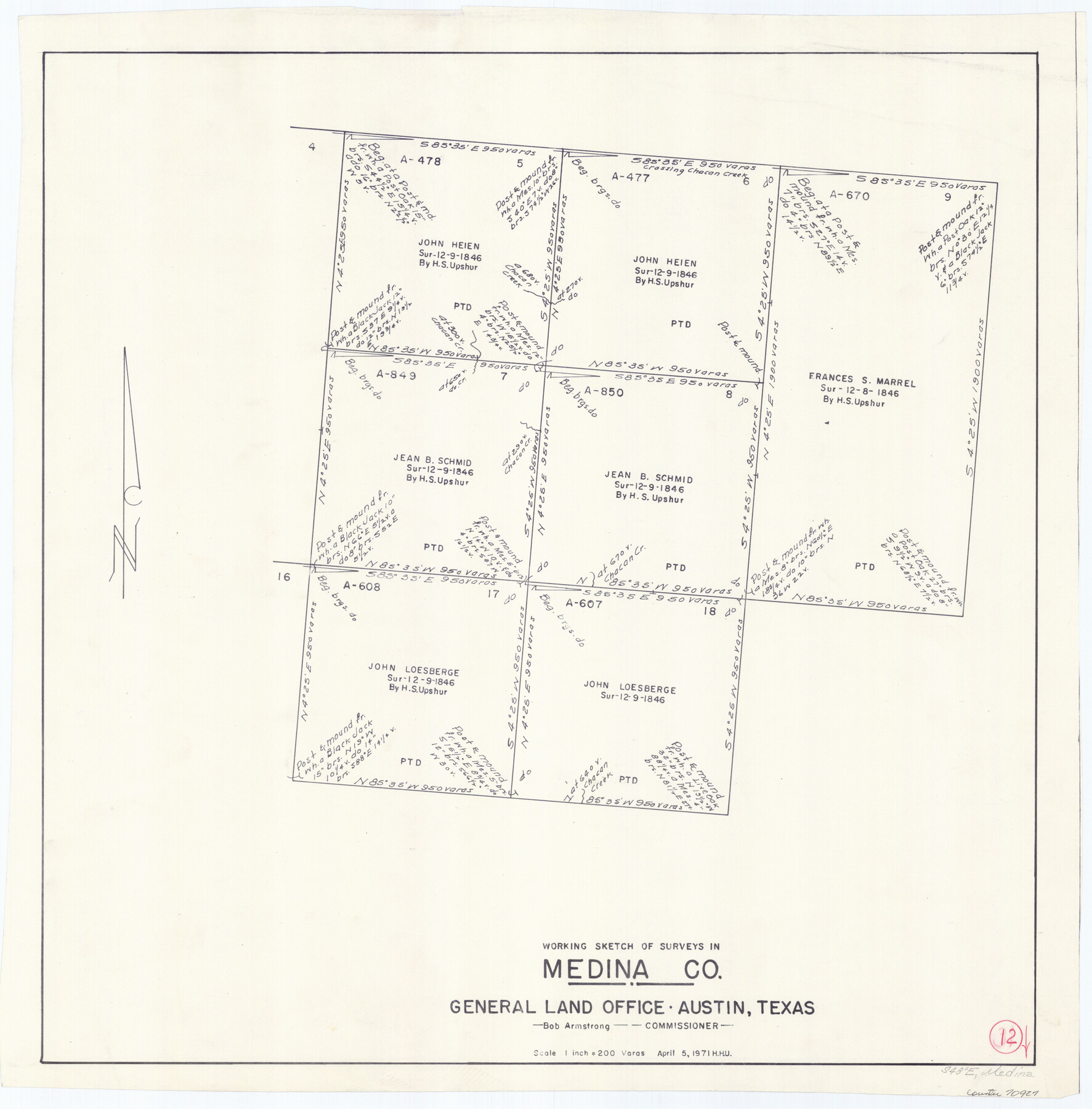
Medina County Working Sketch 12
-
Map/Doc
70927
-
Collection
General Map Collection
-
Object Dates
4/5/1971 (Creation Date)
-
People and Organizations
Herbert H. Ulbricht (Draftsman)
-
Counties
Medina
-
Subjects
Surveying Working Sketch
-
Height x Width
24.2 x 23.9 inches
61.5 x 60.7 cm
-
Scale
1" = 200 varas
Part of: General Map Collection
Garza County Sketch File 31

Print $10.00
- Digital $50.00
Garza County Sketch File 31
1914
Size 13.4 x 8.9 inches
Map/Doc 24104
Millennium in Maps - Exploration

Millennium in Maps - Exploration
Size 20.6 x 31.5 inches
Map/Doc 95931
Edwards-Kinney County Line, Field Notes & Correspondence, 1933

Print $42.00
- Digital $50.00
Edwards-Kinney County Line, Field Notes & Correspondence, 1933
1931
Size 11.2 x 8.7 inches
Map/Doc 62881
Voyages Autour du Monde, et vers les deux poles par terre et par mer - Tome Second

Voyages Autour du Monde, et vers les deux poles par terre et par mer - Tome Second
1782
Map/Doc 97086
Crockett County Working Sketch 57

Print $20.00
- Digital $50.00
Crockett County Working Sketch 57
1954
Size 35.9 x 38.8 inches
Map/Doc 68390
Wood County Sketch File 13

Print $24.00
- Digital $50.00
Wood County Sketch File 13
1866
Size 12.5 x 7.6 inches
Map/Doc 40668
Terrell County Working Sketch 80

Print $20.00
- Digital $50.00
Terrell County Working Sketch 80
1985
Size 20.7 x 36.4 inches
Map/Doc 69601
[Map Showing Panhandle Counties in Texas]
![2087, [Map Showing Panhandle Counties in Texas], General Map Collection](https://historictexasmaps.com/wmedia_w700/maps/2087.tif.jpg)
Print $20.00
- Digital $50.00
[Map Showing Panhandle Counties in Texas]
1876
Size 27.3 x 27.9 inches
Map/Doc 2087
Flight Mission No. BRA-7M, Frame 122, Jefferson County

Print $20.00
- Digital $50.00
Flight Mission No. BRA-7M, Frame 122, Jefferson County
1953
Size 18.7 x 22.3 inches
Map/Doc 85516
Upshur County Working Sketch 5

Print $20.00
- Digital $50.00
Upshur County Working Sketch 5
1941
Size 15.0 x 20.6 inches
Map/Doc 69561
[F. W. & D. C. Ry. Co. Alignment and Right of Way Map, Clay County]
![64734, [F. W. & D. C. Ry. Co. Alignment and Right of Way Map, Clay County], General Map Collection](https://historictexasmaps.com/wmedia_w700/maps/64734-GC.tif.jpg)
Print $20.00
- Digital $50.00
[F. W. & D. C. Ry. Co. Alignment and Right of Way Map, Clay County]
1927
Size 18.6 x 11.8 inches
Map/Doc 64734
Somervell County Sketch File 3

Print $6.00
- Digital $50.00
Somervell County Sketch File 3
1858
Size 8.2 x 3.9 inches
Map/Doc 36797
You may also like
Van Zandt County Boundary File 2

Print $32.00
- Digital $50.00
Van Zandt County Boundary File 2
Size 13.0 x 8.1 inches
Map/Doc 59633
General Highway Map, Potter County, Texas

Print $20.00
General Highway Map, Potter County, Texas
1940
Size 24.6 x 18.3 inches
Map/Doc 79220
Cherokee County

Print $40.00
- Digital $50.00
Cherokee County
1933
Size 54.7 x 38.7 inches
Map/Doc 73104
Reeves County Working Sketch 14

Print $20.00
- Digital $50.00
Reeves County Working Sketch 14
1960
Size 26.5 x 24.9 inches
Map/Doc 63457
Fort Bend County Working Sketch 32

Print $20.00
- Digital $50.00
Fort Bend County Working Sketch 32
2000
Size 36.5 x 42.5 inches
Map/Doc 69238
Parker County Boundary File 1

Print $6.00
- Digital $50.00
Parker County Boundary File 1
Size 11.2 x 8.7 inches
Map/Doc 57833
Dallas, Ft. Worth, & Vicinity, Texas - Regional Map

Dallas, Ft. Worth, & Vicinity, Texas - Regional Map
1997
Size 25.9 x 36.7 inches
Map/Doc 97288


Map of Germany, Switzerland and Northern Italy engraved to illustrate Mitchell's school and family geography

Print $20.00
- Digital $50.00
Map of Germany, Switzerland and Northern Italy engraved to illustrate Mitchell's school and family geography
1840
Size 11.8 x 9.5 inches
Map/Doc 93504
[Surveys in the Travis District along the Colorado River]
![3180, [Surveys in the Travis District along the Colorado River], General Map Collection](https://historictexasmaps.com/wmedia_w700/maps/3180.tif.jpg)
Print $2.00
- Digital $50.00
[Surveys in the Travis District along the Colorado River]
1841
Size 7.0 x 7.3 inches
Map/Doc 3180
Flight Mission No. BQR-22K, Frame 44, Brazoria County

Print $20.00
- Digital $50.00
Flight Mission No. BQR-22K, Frame 44, Brazoria County
1953
Size 18.6 x 22.3 inches
Map/Doc 84128