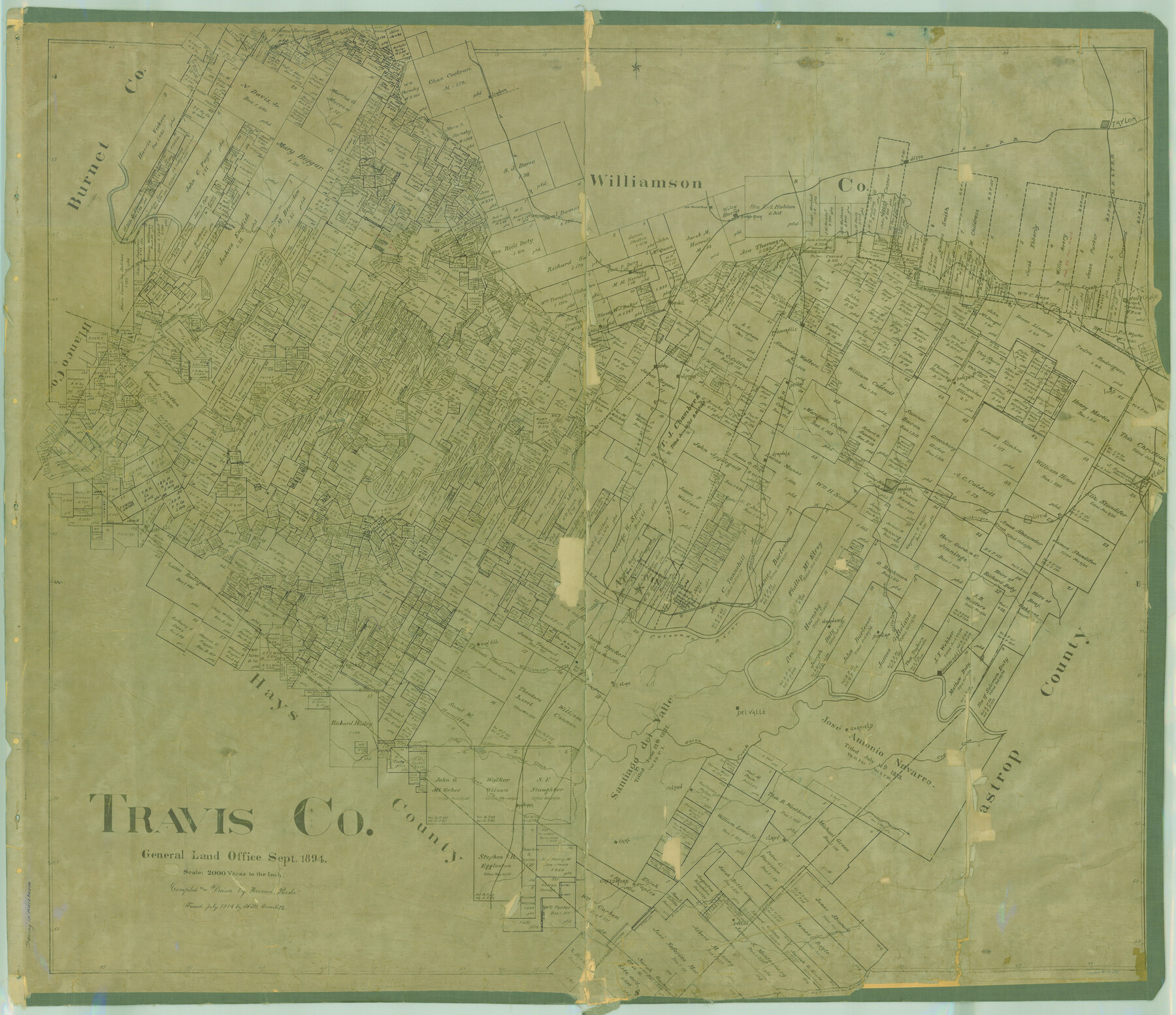
Travis Co.
-
Map/Doc
78388
-
Collection
General Map Collection
-
Object Dates
1894 (Creation Date)
-
People and Organizations
Texas General Land Office (Publisher)
Herman Pressler (Compiler)
Herman Pressler (Draftsman)
-
Counties
Travis
-
Subjects
County
-
Height x Width
41.6 x 48.3 inches
105.7 x 122.7 cm
-
Comments
Traced in July 1914 by H. M. Bramlette.
Note on reverse side: "Copied and hung April 1927 MKB; In use to Nov. 2, 1936".
Help Save Texas History - Adopt Me! -
Features
Grape Creek
Onion Creek
Cedar Creek
Garfield
Cedar Valley
Oak Hill
Williamson Creek
St. Elmo
Webberville
Dunlap
Colorado River
Boggy Creek
Rocky Creek
Neps Branch [of Barton Creek]
Barton Creek
Congress Avenue Bridge
Waller Creek
Austin
Hornsby
Gilleland Creek
Walnut Creek
Little Barton Creek
Nacogdoches Road
Shoal Creek
TCRR
Dead Man's Creek
Hale Creek
Basin Branch of Cypress Creek
Clear Creek
Turner's Branch [of Pedernales River]
Lion Creek
Old San Antonio to Nacogdoches Road
Del Valle
Shingle Hill
Old San Antonio Road
Evelyn
Creedmore
Carl
Elroy
Rock Springs Branch [of Cedar Creek]
Colton
Manchaca
Bear Creek
Slaughter Creek
Brushy Creek
Lund
New Sweden
Pflugerville
Jollyville
Cross Creek
Mud
Pedernales River
Red Bluffs Creek
Deer Creek
Cummings
Dessau
Round Rock
Cedar Park
Cow Creek
Sandy Creek
Cherry Hollow Creek
Old Round Rock
MK&T
Taylor
I&GN
Hutto
Jolly Creek
Bee Cave
Littig
Wilbarger Creek
H&TC
A&NW
Devil's Cañon
Cypress Creek
Basin Branch of Pedernales River
Cat Hollow Creek
Bee Creek
Leander
Harrison Branch [of Pedernales River]
Turkey Creek
Bull Creek
Sprinkle
Manor
Elgin
Cougar Branch [of Pedernales River]
Teck
Duval
Watters
Part of: General Map Collection
La Salle County Sketch File 3

Print $44.00
- Digital $50.00
La Salle County Sketch File 3
1875
Size 15.8 x 29.6 inches
Map/Doc 11978
Henderson County

Print $40.00
- Digital $50.00
Henderson County
1922
Size 33.0 x 62.7 inches
Map/Doc 66861
Flight Mission No. DQN-5K, Frame 149, Calhoun County

Print $20.00
- Digital $50.00
Flight Mission No. DQN-5K, Frame 149, Calhoun County
1953
Size 18.5 x 22.2 inches
Map/Doc 84424
Sutton County Sketch File H

Print $22.00
- Digital $50.00
Sutton County Sketch File H
Size 14.3 x 8.7 inches
Map/Doc 37400
Map of Starr County

Print $40.00
- Digital $50.00
Map of Starr County
1900
Size 51.6 x 25.8 inches
Map/Doc 4046
Galveston County Working Sketch 16

Print $20.00
- Digital $50.00
Galveston County Working Sketch 16
1980
Size 30.5 x 36.9 inches
Map/Doc 69353
Crosby County Working Sketch 1

Print $20.00
- Digital $50.00
Crosby County Working Sketch 1
Size 28.0 x 26.0 inches
Map/Doc 68435
Stonewall County Boundary File 1

Print $34.00
- Digital $50.00
Stonewall County Boundary File 1
Size 9.0 x 8.4 inches
Map/Doc 58938
Presidio County Sketch File 121

Print $57.00
- Digital $50.00
Presidio County Sketch File 121
1998
Size 11.0 x 8.5 inches
Map/Doc 82620
Robertson County Rolled Sketch 5

Print $20.00
- Digital $50.00
Robertson County Rolled Sketch 5
1976
Size 34.1 x 36.4 inches
Map/Doc 9864
Permanent Lakes and Marshes for Mineral Development

Print $20.00
- Digital $50.00
Permanent Lakes and Marshes for Mineral Development
Size 30.6 x 35.2 inches
Map/Doc 73593
Harrison County Sketch File 12

Print $20.00
- Digital $50.00
Harrison County Sketch File 12
Size 21.5 x 24.1 inches
Map/Doc 11687
You may also like
Current Miscellaneous File 39

Print $20.00
- Digital $50.00
Current Miscellaneous File 39
Size 11.2 x 8.8 inches
Map/Doc 73962
Martin County Sketch File 1

Print $66.00
- Digital $50.00
Martin County Sketch File 1
Size 19.3 x 8.9 inches
Map/Doc 30626
[Texas Boundary Line]
![92081, [Texas Boundary Line], Twichell Survey Records](https://historictexasmaps.com/wmedia_w700/maps/92081-1.tif.jpg)
Print $20.00
- Digital $50.00
[Texas Boundary Line]
Size 21.2 x 12.4 inches
Map/Doc 92081

Flight Mission No. DQO-8K, Frame 90, Galveston County

Print $20.00
- Digital $50.00
Flight Mission No. DQO-8K, Frame 90, Galveston County
1952
Size 17.9 x 22.3 inches
Map/Doc 85192
Sketch showing Block R situated in Counties of Castro, Deaf Smith, Randall & Swisher

Print $20.00
- Digital $50.00
Sketch showing Block R situated in Counties of Castro, Deaf Smith, Randall & Swisher
1908
Size 29.0 x 34.4 inches
Map/Doc 90408
Corpus Christi Pass, Texas

Print $20.00
- Digital $50.00
Corpus Christi Pass, Texas
1871
Size 26.1 x 18.3 inches
Map/Doc 72981
Flight Mission No. BRA-16M, Frame 110, Jefferson County

Print $20.00
- Digital $50.00
Flight Mission No. BRA-16M, Frame 110, Jefferson County
1953
Size 18.6 x 22.4 inches
Map/Doc 85720
Tom Green County Sketch File 13

Print $4.00
- Digital $50.00
Tom Green County Sketch File 13
Size 6.3 x 8.4 inches
Map/Doc 38170
Map of Surveys made in Fisher and Miller's Colony

Print $40.00
- Digital $50.00
Map of Surveys made in Fisher and Miller's Colony
1848
Size 48.4 x 57.7 inches
Map/Doc 16830
Shelby County Sketch File 34

Print $3.00
- Digital $50.00
Shelby County Sketch File 34
1847
Size 10.1 x 15.7 inches
Map/Doc 36674
The Buffalo Bayou, Brazos and Colorado Railroad (BBB&C)

The Buffalo Bayou, Brazos and Colorado Railroad (BBB&C)
2022
Size 8.5 x 11.0 inches
Map/Doc 97088