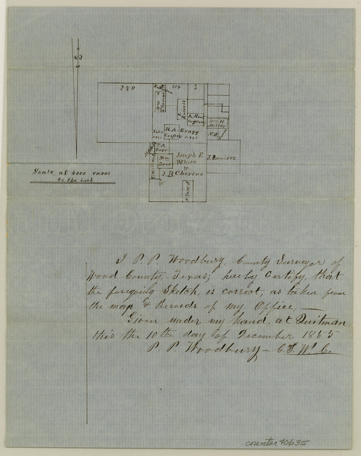
Wood County Sketch File 4
[Sketch of surveys northeast of Quitman near the Gragg survey]
-
Map/Doc
40635
-
Collection
General Map Collection
-
Object Dates
12/10/1855 (Creation Date)
-
People and Organizations
P.P. Woodbury (Surveyor/Engineer)
-
Counties
Wood
-
Subjects
Surveying Sketch File
-
Height x Width
10.2 x 8.1 inches
25.9 x 20.6 cm
-
Medium
paper, manuscript
-
Scale
1" = 4000 varas
Part of: General Map Collection
Controlled Mosaic by Jack Amman Photogrammetric Engineers, Inc - Sheet 19

Print $20.00
- Digital $50.00
Controlled Mosaic by Jack Amman Photogrammetric Engineers, Inc - Sheet 19
1954
Size 19.3 x 24.0 inches
Map/Doc 83465
Falls County Sketch File 31

Print $4.00
- Digital $50.00
Falls County Sketch File 31
1881
Size 14.5 x 8.8 inches
Map/Doc 22439
A Geographically Correct Map of the State of Texas

Print $20.00
- Digital $50.00
A Geographically Correct Map of the State of Texas
1876
Size 20.4 x 21.7 inches
Map/Doc 95361
Flight Mission No. DQO-3K, Frame 33, Galveston County

Print $20.00
- Digital $50.00
Flight Mission No. DQO-3K, Frame 33, Galveston County
1952
Size 18.8 x 22.4 inches
Map/Doc 85074
Eastland County Working Sketch 28

Print $20.00
- Digital $50.00
Eastland County Working Sketch 28
1952
Size 25.0 x 21.3 inches
Map/Doc 68809
Trinity County Sketch File 23

Print $26.00
- Digital $50.00
Trinity County Sketch File 23
1861
Size 6.9 x 8.3 inches
Map/Doc 38552
Gaines County Boundary File 1

Print $90.00
- Digital $50.00
Gaines County Boundary File 1
Size 14.4 x 9.0 inches
Map/Doc 53626
Panola County Sketch File 9

Print $8.00
- Digital $50.00
Panola County Sketch File 9
Size 13.9 x 8.5 inches
Map/Doc 33461
Howard County Boundary File 2b

Print $8.00
- Digital $50.00
Howard County Boundary File 2b
Size 11.4 x 8.8 inches
Map/Doc 55122
Liberty County Working Sketch 34

Print $20.00
- Digital $50.00
Liberty County Working Sketch 34
1946
Size 26.7 x 21.2 inches
Map/Doc 70493
Duval County Rolled Sketch 37

Print $20.00
- Digital $50.00
Duval County Rolled Sketch 37
Size 27.1 x 17.9 inches
Map/Doc 5752
Fisher County

Print $20.00
- Digital $50.00
Fisher County
1921
Size 45.8 x 40.4 inches
Map/Doc 66822
You may also like
Coast Chart No. 210 Aransas Pass and Corpus Christi Bay with the coast to latitude 27° 12' Texas

Print $20.00
- Digital $50.00
Coast Chart No. 210 Aransas Pass and Corpus Christi Bay with the coast to latitude 27° 12' Texas
1887
Size 27.1 x 18.3 inches
Map/Doc 72804
The Republic County of Colorado. Proposed, Late Fall 1837

Print $20.00
The Republic County of Colorado. Proposed, Late Fall 1837
2020
Size 18.4 x 21.7 inches
Map/Doc 96118
Morris County Rolled Sketch 2A

Print $20.00
- Digital $50.00
Morris County Rolled Sketch 2A
Size 24.0 x 18.7 inches
Map/Doc 10287
Uvalde County Rolled Sketch 8

Print $20.00
- Digital $50.00
Uvalde County Rolled Sketch 8
Size 21.3 x 37.5 inches
Map/Doc 8093
Pecos County Working Sketch 136

Print $20.00
- Digital $50.00
Pecos County Working Sketch 136
1981
Size 31.8 x 28.4 inches
Map/Doc 71610
Liberty County Rolled Sketch WC

Print $107.00
- Digital $50.00
Liberty County Rolled Sketch WC
1934
Size 10.4 x 15.3 inches
Map/Doc 46561
Baylor County Rolled Sketch 12

Print $20.00
- Digital $50.00
Baylor County Rolled Sketch 12
1986
Size 22.4 x 36.0 inches
Map/Doc 5129

Flight Mission No. CGI-4N, Frame 186, Cameron County

Print $20.00
- Digital $50.00
Flight Mission No. CGI-4N, Frame 186, Cameron County
1955
Size 18.5 x 22.2 inches
Map/Doc 84689
Hudspeth County Working Sketch 42

Print $20.00
- Digital $50.00
Hudspeth County Working Sketch 42
1981
Size 34.2 x 36.5 inches
Map/Doc 66327
Val Verde County Sketch File XXX9

Print $4.00
- Digital $50.00
Val Verde County Sketch File XXX9
Size 11.0 x 8.5 inches
Map/Doc 39108
[R. T. Bucy's Survey 3, League 321]
![91348, [R. T. Bucy's Survey 3, League 321], Twichell Survey Records](https://historictexasmaps.com/wmedia_w700/maps/91348.tif.jpg)
Digital $50.00
[R. T. Bucy's Survey 3, League 321]
Map/Doc 91348